![](/images/other/stat-length.png)
![Randonnée Vélo Dole - G1, La Bresse - Photo](https://media.geolcdn.com/t/1900/400/ext.pjpeg?maxdim=2&url=https%3A%2F%2Fstatic1.geolcdn.com%2Fsiteimages%2Fupload%2Ffiles%2F1524743154velo.jpg)
G1, La Bresse
albert39
Utilisateur
![Longueur](/images/other/stat-length.png)
Longueur
89 km
![Altitude max](https://static1.geolcdn.com/siteimages/upload/files/1508320355ic_sort_altitude_max_24dp.png)
Altitude max
266 m
![Dénivelé positif](https://static1.geolcdn.com/siteimages/upload/files/1508320355ic_sort_den_pos_24dp.png)
Dénivelé positif
791 m
![Km-Effort](/images/other/stat-length.png)
Km-Effort
100 km
![Altitude min](https://static1.geolcdn.com/siteimages/upload/files/1508320355ic_sort_altitude_min_24dp.png)
Altitude min
185 m
![Dénivelé négatif](https://static1.geolcdn.com/siteimages/upload/files/1508320355ic_sort_den_neg_24dp.png)
Dénivelé négatif
791 m
![Boucle](https://static1.geolcdn.com/siteimages/upload/files/16400158638029165_repeat_loop_refresh_sync_direction_icon.png)
Boucle
Oui
Date de création :
2014-12-10 00:00:00.0
Dernière modification :
2014-12-10 00:00:00.0
![Vélo](https://static1.geolcdn.com/sitytour/trail-icons/200.png)
3h51
Difficulté : Difficile
![Scannez ce code QR pour ouvrir la randonnée dans l'application SityTrail](https://capi.geolives.com/qq0zvz2zws4bq2lad0pu/sitytour/trails/202189/qr.png?size=200)
Application GPS de randonnée GRATUITE
À propos
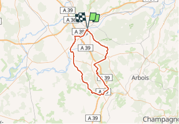
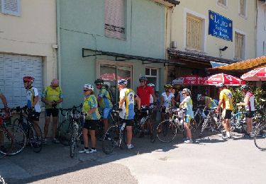
Randonnée Vélo de 89 km à découvrir à Bourgogne-Franche-Comté, Jura, Dole. Cette randonnée est proposée par albert39.
Description
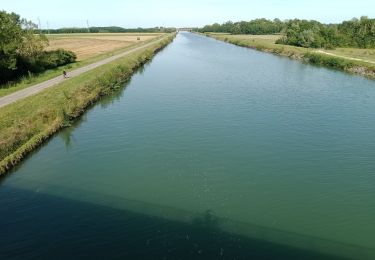
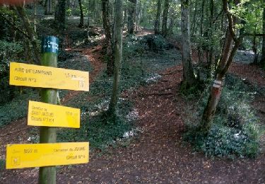
Groupe de 15, départ du parc Isis, direction Belmont, Bans, Villers-Robert, Séligney, Bretenières, Bersaillin, Foulnay, Les Deux-Fays, Pleure, Chaussin, Champdivers, Tavaux, retour canal. Circuit exigent et rouleur.
Localisation
Pays :
France
Région :
Bourgogne-Franche-Comté
Département/Province :
Jura
Commune :
Dole
Localité :
Unknown
Départ:(Dec)
Départ:(UTM)
688440 ; 5218071 (31T) N.
Commentaires
Randonnées à proximité
![Randonnée Marche Jouhe - Mont Roland 11.7km 20161215 - Photo](https://media.geolcdn.com/t/375/260/ext.jpg?maxdim=2&url=https%3A%2F%2Fstatic1.geolcdn.com%2Fsiteimages%2Fupload%2Ffiles%2F1553511878bg_sport_marche.png)
![Marche Marche](https://static1.geolcdn.com/sitytour/trail-icons/101.png)
Mont Roland 11.7km 20161215
Marche
Très facile
(2)
Jouhe,
Bourgogne-Franche-Comté,
Jura,
France
![](/images/other/stat-length.png)
11,8 km | 15,4 km-effort
3h 18min
![](https://static1.geolcdn.com/siteimages/upload/files/16400158638029165_repeat_loop_refresh_sync_direction_icon.png)
Oui
![Randonnée Marche Dole - Dole ville - Photo](https://media.geolcdn.com/t/375/260/e28aad6a-c7e5-401c-94fb-452df6c86b47.jpg&format=jpg&maxdim=2)
![Marche Marche](https://static1.geolcdn.com/sitytour/trail-icons/101.png)
![Randonnée Marche Dole - Via Cluny: de Dole (Jura) à Cluny (Bourgogne) - Photo](https://media.geolcdn.com/t/375/260/1092a6f8-d0c7-4e5e-a178-164a2812cb66.jpg&format=jpg&maxdim=2)
![Marche Marche](https://static1.geolcdn.com/sitytour/trail-icons/101.png)
Via Cluny: de Dole (Jura) à Cluny (Bourgogne)
Marche
Très difficile
Dole,
Bourgogne-Franche-Comté,
Jura,
France
![](/images/other/stat-length.png)
360 km | 478 km-effort
108h 38min
![](https://static1.geolcdn.com/siteimages/upload/files/16400158638029165_repeat_loop_refresh_sync_direction_icon.png)
Non
![Randonnée Vélo de route Dole - mn05 - Photo](https://media.geolcdn.com/t/375/260/5ece753a-d519-46d1-b96a-31a274298d2e.jpg&format=jpg&maxdim=2)
![Vélo de route Vélo de route](https://static1.geolcdn.com/sitytour/trail-icons/201.png)
mn05
Vélo de route
Très difficile
Dole,
Bourgogne-Franche-Comté,
Jura,
France
![](/images/other/stat-length.png)
58 km | 63 km-effort
7h 44min
![](https://static1.geolcdn.com/siteimages/upload/files/16400158638029165_repeat_loop_refresh_sync_direction_icon.png)
Non
![Randonnée Marche Dole - muguet confinement - Photo](https://media.geolcdn.com/t/375/260/574ce2bd-ddb7-4098-9610-087d7bd33043.jpg&format=jpg&maxdim=2)
![Marche Marche](https://static1.geolcdn.com/sitytour/trail-icons/101.png)
muguet confinement
Marche
Facile
Dole,
Bourgogne-Franche-Comté,
Jura,
France
![](/images/other/stat-length.png)
8 km | 9 km-effort
2h 16min
![](https://static1.geolcdn.com/siteimages/upload/files/16400158638029165_repeat_loop_refresh_sync_direction_icon.png)
Oui
![Randonnée Marche Jouhe - g)Etapa 7 - Photo](https://media.geolcdn.com/t/375/260/ext.jpg?maxdim=2&url=https%3A%2F%2Fservices.sitytrail.com%2FGeolivesWS%2FDownloadMedia.ashx%3FTrailID%3D711082%26Media%3D20170306151955.jpg)
![Marche Marche](https://static1.geolcdn.com/sitytour/trail-icons/101.png)
g)Etapa 7
Marche
Facile
Jouhe,
Bourgogne-Franche-Comté,
Jura,
France
![](/images/other/stat-length.png)
26 km | 31 km-effort
2h 4min
![](https://static1.geolcdn.com/siteimages/upload/files/16400158638029165_repeat_loop_refresh_sync_direction_icon.png)
Non
![Randonnée Marche Dole - Sentier des chênes rouges - Photo](https://media.geolcdn.com/t/375/260/ext.jpg?maxdim=2&url=https%3A%2F%2Fservices.sitytrail.com%2FGeolivesWS%2FDownloadMedia.ashx%3FTrailID%3D476404%26Media%3Dfix__20150927175830.jpg)
![Marche Marche](https://static1.geolcdn.com/sitytour/trail-icons/101.png)
Sentier des chênes rouges
Marche
Facile
Dole,
Bourgogne-Franche-Comté,
Jura,
France
![](/images/other/stat-length.png)
11,6 km | 13,7 km-effort
3h 47min
![](https://static1.geolcdn.com/siteimages/upload/files/16400158638029165_repeat_loop_refresh_sync_direction_icon.png)
Oui
![Randonnée Vélo Dole - Bletterans - Photo](https://media.geolcdn.com/t/375/260/ext.jpg?maxdim=2&url=https%3A%2F%2Fservices.sitytrail.com%2FGeolivesWS%2FDownloadMedia.ashx%3FTrailID%3D466291%26Media%3Dfix__20150828142451.jpg)
![Vélo Vélo](https://static1.geolcdn.com/sitytour/trail-icons/200.png)
Bletterans
Vélo
Difficile
Dole,
Bourgogne-Franche-Comté,
Jura,
France
![](/images/other/stat-length.png)
125 km | 138 km-effort
6h 11min
![](https://static1.geolcdn.com/siteimages/upload/files/16400158638029165_repeat_loop_refresh_sync_direction_icon.png)
Oui
![Randonnée Marche nordique Jouhe - Circuit Mont-Roland - Photo](https://media.geolcdn.com/t/375/260/ext.jpg?maxdim=2&url=https%3A%2F%2Fservices.sitytrail.com%2FGeolivesWS%2FDownloadMedia.ashx%3FTrailID%3D344188%26Media%3Dfix__20140911154422.jpg)
![Marche nordique Marche nordique](https://static1.geolcdn.com/sitytour/trail-icons/102.png)
Circuit Mont-Roland
Marche nordique
Difficile
Jouhe,
Bourgogne-Franche-Comté,
Jura,
France
![](/images/other/stat-length.png)
11 km | 16,1 km-effort
2h 9min
![](https://static1.geolcdn.com/siteimages/upload/files/16400158638029165_repeat_loop_refresh_sync_direction_icon.png)
Oui