![](/images/other/stat-length.png)
Le Grand Veymont par la Coche
Philindy26
Utilisateur
![Longueur](/images/other/stat-length.png)
![Altitude max](https://static1.geolcdn.com/siteimages/upload/files/1508320355ic_sort_altitude_max_24dp.png)
![Dénivelé positif](https://static1.geolcdn.com/siteimages/upload/files/1508320355ic_sort_den_pos_24dp.png)
![Km-Effort](/images/other/stat-length.png)
![Altitude min](https://static1.geolcdn.com/siteimages/upload/files/1508320355ic_sort_altitude_min_24dp.png)
![Dénivelé négatif](https://static1.geolcdn.com/siteimages/upload/files/1508320355ic_sort_den_neg_24dp.png)
![Boucle](https://static1.geolcdn.com/siteimages/upload/files/16400158638029165_repeat_loop_refresh_sync_direction_icon.png)
![Marche](https://static1.geolcdn.com/sitytour/trail-icons/101.png)
5h30
Difficulté : Très difficile
![Scannez ce code QR pour ouvrir la randonnée dans l'application SityTrail](https://capi.geolives.com/qq0zvz2zws4bq2lad0pu/sitytour/trails/2021198/qr.png?size=200)
Application GPS de randonnée GRATUITE
À propos
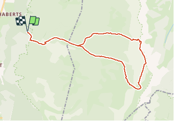
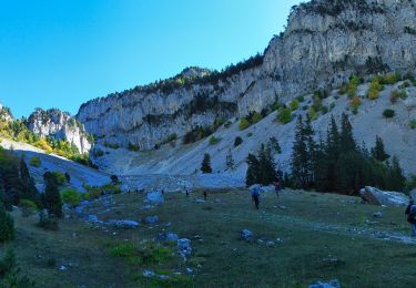
Randonnée Marche de 20 km à découvrir à Auvergne-Rhône-Alpes, Drôme, Saint-Agnan-en-Vercors. Cette randonnée est proposée par Philindy26.
Description
Départ de la Coche, Saint-Agnan-en-Vercors (1352 m)...
Géolocalisation (Google Maps) : https://goo.gl/maps/2fF9NcweNjqnhpU3A .
Prendre la direction du Pré Grandu (1365 m), montée par la Nouvelle Jasse de la Chau (1614 m).
Montée au Pas de la Ville (1925 m), puis le sommet (2341 m).
Descendre par le Pas des Chatons (1827 m), puis direction la Fontaine des Serrons (1670 m) et Pré Grandu.
Localisation
Commentaires
Randonnées à proximité
![Randonnée Marche Saint-Agnan-en-Vercors - Vercors - La Coche Grand Veymont Queyrie - Photo](https://media.geolcdn.com/t/375/260/ext.jpg?maxdim=2&url=https%3A%2F%2Fstatic1.geolcdn.com%2Fsiteimages%2Fupload%2Ffiles%2F1553511878bg_sport_marche.png)
![Marche Marche](https://static1.geolcdn.com/sitytour/trail-icons/101.png)
Marche
![](/images/other/stat-length.png)
![](https://static1.geolcdn.com/siteimages/upload/files/16400158638029165_repeat_loop_refresh_sync_direction_icon.png)
![Randonnée Marche Saint-Agnan-en-Vercors - jour 1 Sommet de Peyre rouge - Photo](https://media.geolcdn.com/t/375/260/ac51eeac-99cf-4e9b-b15c-3c23c3dc182f.jpg&format=jpg&maxdim=2)
![Marche Marche](https://static1.geolcdn.com/sitytour/trail-icons/101.png)
Marche
![](/images/other/stat-length.png)
![](https://static1.geolcdn.com/siteimages/upload/files/16400158638029165_repeat_loop_refresh_sync_direction_icon.png)
![Randonnée Marche Saint-Agnan-en-Vercors - 26 tiolache - Photo](https://media.geolcdn.com/t/375/260/901b344f-b319-4266-9f0a-69075395b314.jpg&format=jpg&maxdim=2)
![Marche Marche](https://static1.geolcdn.com/sitytour/trail-icons/101.png)
Marche
![](/images/other/stat-length.png)
![](https://static1.geolcdn.com/siteimages/upload/files/16400158638029165_repeat_loop_refresh_sync_direction_icon.png)
![Randonnée Marche Saint-Agnan-en-Vercors - Col du Rousset : Plateau de Beure 16km. - Photo](https://media.geolcdn.com/t/375/260/5ac08b8d-daa5-4b6c-97be-aa6c9a366e1e.jpg&format=jpg&maxdim=2)
![Marche Marche](https://static1.geolcdn.com/sitytour/trail-icons/101.png)
Marche
![](/images/other/stat-length.png)
![](https://static1.geolcdn.com/siteimages/upload/files/16400158638029165_repeat_loop_refresh_sync_direction_icon.png)
![Randonnée Raquettes à neige Saint-Agnan-en-Vercors - Rousset-Plateau de Beure 7,5km - Photo](https://media.geolcdn.com/t/375/260/8a7e5d61-0b73-4afe-90fa-65450301c9eb.jpg&format=jpg&maxdim=2)
![Raquettes à neige Raquettes à neige](https://static1.geolcdn.com/sitytour/trail-icons/504.png)
Raquettes à neige
![](/images/other/stat-length.png)
![](https://static1.geolcdn.com/siteimages/upload/files/16400158638029165_repeat_loop_refresh_sync_direction_icon.png)
![Randonnée Marche Saint-Agnan-en-Vercors - Les Hauts Plateaux du Vercors - Photo](https://media.geolcdn.com/t/375/260/ec115f7c-48d5-47de-819e-7d8cda136852.jpg&format=jpg&maxdim=2)
![Marche Marche](https://static1.geolcdn.com/sitytour/trail-icons/101.png)
Marche
![](/images/other/stat-length.png)
![](https://static1.geolcdn.com/siteimages/upload/files/16400158638029165_repeat_loop_refresh_sync_direction_icon.png)
![Randonnée Raquettes à neige Saint-Agnan-en-Vercors - plateau de beure - Photo](https://media.geolcdn.com/t/375/260/93bcd910-0696-44ac-9a1b-e8280ab70ca4.jpg&format=jpg&maxdim=2)
![Raquettes à neige Raquettes à neige](https://static1.geolcdn.com/sitytour/trail-icons/504.png)
Raquettes à neige
![](/images/other/stat-length.png)
![](https://static1.geolcdn.com/siteimages/upload/files/16400158638029165_repeat_loop_refresh_sync_direction_icon.png)
![Randonnée Marche Saint-Agnan-en-Vercors - Rando ASPTT Pas des Econdus Pas de Chabrinel - Photo](https://media.geolcdn.com/t/375/260/376accd3-830f-4cc1-9203-27a18cc5040b.jpg&format=jpg&maxdim=2)
![Marche Marche](https://static1.geolcdn.com/sitytour/trail-icons/101.png)
Marche
![](/images/other/stat-length.png)
![](https://static1.geolcdn.com/siteimages/upload/files/16400158638029165_repeat_loop_refresh_sync_direction_icon.png)
![Randonnée Marche Saint-Agnan-en-Vercors - trop Alexis - Photo](https://media.geolcdn.com/t/375/260/c36b90eb-63fa-4a9c-9518-bbd91f5e8a29.jpg&format=jpg&maxdim=2)
![Marche Marche](https://static1.geolcdn.com/sitytour/trail-icons/101.png)
Marche
![](/images/other/stat-length.png)
![](https://static1.geolcdn.com/siteimages/upload/files/16400158638029165_repeat_loop_refresh_sync_direction_icon.png)