Randonnée A pied Éterville - ETERVILLE - Photo
 cecirealain
cecirealain

Utilisateur

© OpenStreetMap contributors
Longueur
Longueur
9,3 km
Altitude max
Altitude max
83 m
Dénivelé positif
Dénivelé positif
88 m
Km-Effort
Km-Effort  
10,5 km
Altitude min
Altitude min
13 m
Dénivelé négatif
Dénivelé négatif
89 m
Boucle
Boucle
Oui
Date de création :
2018-12-22 09:44:22.907
Dernière modification :
2018-12-22 09:50:52.068

(0 Avis)

A pied
A pied
3h00
Difficulté : Facile

Scannez ce code QR pour ouvrir la randonnée dans l'application SityTrail

Application GPS de randonnée GRATUITE

Logo SityTrail SityTrail

IGN / Instituts géographiques

Télécharger SityTrail sur l'App Store Télécharger SityTrail sur Google Play

Logo SityTrail SityTrail World

Le monde est à vous

Télécharger SityTrail sur l'App Store Télécharger SityTrail sur Google Play Télécharger SityTrail sur Huawei AppGallery

À propos

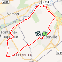
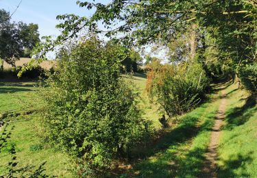
Randonnée A pied de 9,3 km à découvrir à Normandie, Calvados, Éterville. Cette randonnée est proposée par cecirealain.

Description

randonnée facile en passant par Fontaine-Etoupefour et Le Rocreuil .

Profil altimétrique

Localisation

Pays :
France
Région :
Normandie
Département/Province :
Calvados
Commune :
Éterville
Localité :
Unknown
Départ:(UTM)
687389 ; 5446611 (30U) N.

Randonnées à proximité

Randonnée V.T.T. Caen - Accro Vélo 36 Km - Photo
V.T.T.
tracegps

V.T.T.

Moyen
(2)
Caen, Normandie, Calvados, France
35 km | 39 km-effort
2h 15min
Oui
Randonnée Marche Vieux - Vieux-jp - Photo
Marche
gr1346

Marche

Moyen
(1)
Vieux, Normandie, Calvados, France
8,9 km | 10,4 km-effort
2h 37min
Non
Randonnée V.T.T. Saint-André-sur-Orne - La St André  - Photo
V.T.T.
mikeleguerrier

V.T.T.

(1)
Saint-André-sur-Orne, Normandie, Calvados, France
32 km | 37 km-effort
3h 0min
Oui
Randonnée V.T.T. May-sur-Orne - les mines d'or....ne 2016 65 km - Photo
V.T.T.
albers

V.T.T.

Moyen
(1)
May-sur-Orne, Normandie, Calvados, France
65 km | 79 km-effort
5h 4min
Oui
Randonnée Marche Bretteville-sur-Odon - Bretteville-s-Odon - Photo
Marche
gr1346

Marche

Facile
(1)
Bretteville-sur-Odon, Normandie, Calvados, France
6 km | 6,5 km-effort
1h 27min
Oui
Randonnée sport Saint-André-sur-Orne - St André sur orne - Photo
sport
papylou7

sport

Très facile
Saint-André-sur-Orne, Normandie, Calvados, France
13,8 km | 16 km-effort
Inconnu
Non
Randonnée sport Vieux - Autour de Vieux la Romaine  - Photo
sport
papylou7

sport

Très facile
Vieux, Normandie, Calvados, France
35 km | 40 km-effort
Inconnu
Non
Randonnée V.T.T. Baron-sur-Odon - VTT Pré-Bocage 44 km - Photo
V.T.T.
BureauChris

V.T.T.

Très difficile
Baron-sur-Odon, Normandie, Calvados, France
44 km | 52 km-effort
3h 29min
Oui
Randonnée V.T.T. Caen - new trek rapide - Photo
V.T.T.
paspas28

V.T.T.

Facile
Caen, Normandie, Calvados, France
39 km | 44 km-effort
2h 31min
Non


Fermer
Mes abonnements