Randonnée Marche Bout-du-Pont-de-l'Arn - Cucussac - Banquet 2 - Photo
 mauriceilhe
mauriceilhe

Utilisateur

© OpenStreetMap contributors
Longueur
Longueur
10,1 km
Altitude max
Altitude max
578 m
Dénivelé positif
Dénivelé positif
228 m
Km-Effort
Km-Effort  
13,1 km
Altitude min
Altitude min
396 m
Dénivelé négatif
Dénivelé négatif
228 m
Boucle
Boucle
Oui
Date de création :
2018-11-20 14:02:45.485
Dernière modification :
2018-11-20 18:13:35.985

(0 Avis)

Marche
Marche
2h40
Difficulté : Facile

Scannez ce code QR pour ouvrir la randonnée dans l'application SityTrail

Application GPS de randonnée GRATUITE

Logo SityTrail SityTrail

IGN / Instituts géographiques

Télécharger SityTrail sur l'App Store Télécharger SityTrail sur Google Play

Logo SityTrail SityTrail World

Le monde est à vous

Télécharger SityTrail sur l'App Store Télécharger SityTrail sur Google Play Télécharger SityTrail sur Huawei AppGallery

À propos

Randonnée Marche de 10,1 km à découvrir à Occitanie, Tarn, Bout-du-Pont-de-l'Arn. Cette randonnée est proposée par mauriceilhe.

Profil altimétrique

Localisation

Pays :
France
Région :
Occitanie
Département/Province :
Tarn
Commune :
Bout-du-Pont-de-l'Arn
Localité :
Unknown
Départ:(UTM)
453844 ; 4817387 (31T) N.

Randonnées à proximité

Randonnée Marche Mazamet - Mazamet - Hautpoul - Photo
Marche
tracegps

Marche

Difficile
(1)
Mazamet, Occitanie, Tarn, France
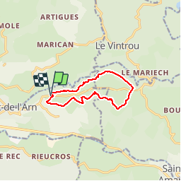
17,4 km | 29 km-effort
6h 30min
Oui
Randonnée Marche Mazamet - Maeamet la passerelle - Photo
Marche
ombrabella

Marche

Moyen
Mazamet, Occitanie, Tarn, France
4,5 km | 8,6 km-effort
1h 32min
Oui
Randonnée Marche Mazamet - Passerelle de Mazamet et village médiéval d'Hautpoul - Photo
Marche
Dominique48

Marche

Difficile
Mazamet, Occitanie, Tarn, France
3,2 km | 6,9 km-effort
1h 41min
Oui
Randonnée Marche Mazamet - depuis HAUPOULet  en 2 boucles - Photo
Marche
chrisgps

Marche

Très facile
Mazamet, Occitanie, Tarn, France
14,2 km | 23 km-effort
6h 6min
Oui
Randonnée Marche Le Vintrou - la Fontaine d'Artigues - Photo
Marche
Pierre11

Marche

Facile
Le Vintrou, Occitanie, Tarn, France
13,5 km | 18,7 km-effort
4h 4min
Oui
Randonnée Marche Pont-de-l'Arn - Sagnecroze Vintrou Betges - Photo
Marche
miqueljp

Marche

Moyen
(1)
Pont-de-l'Arn, Occitanie, Tarn, France
10,3 km | 13,8 km-effort
2h 45min
Oui
Randonnée Marche Pont-de-l'Arn - saint baudille - Photo
Marche
ablatge

Marche

Moyen
Pont-de-l'Arn, Occitanie, Tarn, France
6,8 km | 8,7 km-effort
1h 50min
Oui
Randonnée Marche Saint-Amans-Soult - Le sentier des Gentilshommes Verriers - Saint Amand Soult - Photo
Marche
tracegps

Marche

Moyen
Saint-Amans-Soult, Occitanie, Tarn, France
19,9 km | 31 km-effort
5h 30min
Oui
Randonnée V.T.T. Pont-de-l'Arn -  Barrage du Pas des Bêtes - Sidobre - Photo
V.T.T.
tracegps

V.T.T.

Moyen
Pont-de-l'Arn, Occitanie, Tarn, France
46 km | 65 km-effort
3h 49min
Oui


Fermer
Mes abonnements