![](/images/other/stat-length.png)
![Randonnée Marche Ventron - Parking Refuge des Places - Grand Ventron -Chalet Vaxelaire - Photo](https://media.geolcdn.com/t/1900/400/ext.pjpeg?maxdim=2&url=https%3A%2F%2Fstatic1.geolcdn.com%2Fsiteimages%2Fupload%2Ffiles%2F1553511878bg_sport_marche.png)
Parking Refuge des Places - Grand Ventron -Chalet Vaxelaire
patrickbeyrath
Utilisateur
![Longueur](/images/other/stat-length.png)
Longueur
11,2 km
![Altitude max](https://static1.geolcdn.com/siteimages/upload/files/1508320355ic_sort_altitude_max_24dp.png)
Altitude max
1155 m
![Dénivelé positif](https://static1.geolcdn.com/siteimages/upload/files/1508320355ic_sort_den_pos_24dp.png)
Dénivelé positif
418 m
![Km-Effort](/images/other/stat-length.png)
Km-Effort
16,8 km
![Altitude min](https://static1.geolcdn.com/siteimages/upload/files/1508320355ic_sort_altitude_min_24dp.png)
Altitude min
844 m
![Dénivelé négatif](https://static1.geolcdn.com/siteimages/upload/files/1508320355ic_sort_den_neg_24dp.png)
Dénivelé négatif
418 m
![Boucle](https://static1.geolcdn.com/siteimages/upload/files/16400158638029165_repeat_loop_refresh_sync_direction_icon.png)
Boucle
Oui
Date de création :
2018-11-16 08:31:10.329
Dernière modification :
2018-11-16 09:22:54.555
![Marche](https://static1.geolcdn.com/sitytour/trail-icons/101.png)
3h29
Difficulté : Difficile
![Scannez ce code QR pour ouvrir la randonnée dans l'application SityTrail](https://capi.geolives.com/qq0zvz2zws4bq2lad0pu/sitytour/trails/2016763/qr.png?size=200)
Application GPS de randonnée GRATUITE
À propos
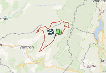
Randonnée Marche de 11,2 km à découvrir à Grand Est, Vosges, Ventron. Cette randonnée est proposée par patrickbeyrath.
Description
Parking Refuge des Places puis rond rouge le Grand Ventron puis triangle jaune vers la Tête du Brochet puis triangle rouge vers la Zimette et prendre triangle bleu Chalet Vaxelaire puis chevalet rouge Borne l' Orbi et retour rRefuge des Places par chevalet rouge
Localisation
Pays :
France
Région :
Grand Est
Département/Province :
Vosges
Commune :
Ventron
Localité :
Unknown
Départ:(Dec)
Départ:(UTM)
343585 ; 5312676 (32T) N.
Commentaires
Randonnées à proximité
![Randonnée Marche Wildenstein - 2022-02-20 Marche Kruth Grand Ventron - Photo](https://media.geolcdn.com/t/375/260/74324e84-ba09-479c-87ba-50417488039d.jpg&format=jpg&maxdim=2)
![Marche Marche](https://static1.geolcdn.com/sitytour/trail-icons/101.png)
2022-02-20 Marche Kruth Grand Ventron
Marche
Très difficile
(1)
Wildenstein,
Grand Est,
Haut-Rhin,
France
![](/images/other/stat-length.png)
16,8 km | 27 km-effort
4h 52min
![](https://static1.geolcdn.com/siteimages/upload/files/16400158638029165_repeat_loop_refresh_sync_direction_icon.png)
Oui
![Randonnée Marche Kruth - Autour du lac de Kruth-Wildenstein - Photo](https://media.geolcdn.com/t/375/260/c1e79833-f011-4190-a625-acd1b44dc0b0.jpeg&format=jpg&maxdim=2)
![Marche Marche](https://static1.geolcdn.com/sitytour/trail-icons/101.png)
Autour du lac de Kruth-Wildenstein
Marche
Moyen
(1)
Kruth,
Grand Est,
Haut-Rhin,
France
![](/images/other/stat-length.png)
7,6 km | 12,7 km-effort
3h 15min
![](https://static1.geolcdn.com/siteimages/upload/files/16400158638029165_repeat_loop_refresh_sync_direction_icon.png)
Oui
![Randonnée Marche Wildenstein - TREK ALSACIEN (boucle de Wildenstein) - Photo](https://media.geolcdn.com/t/375/260/319755c6-b355-43a3-9980-ff414aa67ddf.jpg&format=jpg&maxdim=2)
![Marche Marche](https://static1.geolcdn.com/sitytour/trail-icons/101.png)
TREK ALSACIEN (boucle de Wildenstein)
Marche
Difficile
(1)
Wildenstein,
Grand Est,
Haut-Rhin,
France
![](/images/other/stat-length.png)
15,4 km | 24 km-effort
5h 20min
![](https://static1.geolcdn.com/siteimages/upload/files/16400158638029165_repeat_loop_refresh_sync_direction_icon.png)
Oui
![Randonnée Marche Cornimont - Xoulces _ Grand Ventron _ Vieille Montagne - Photo](https://media.geolcdn.com/t/375/260/ext.jpg?maxdim=2&url=https%3A%2F%2Fservices.sitytrail.com%2FGeolivesWS%2FDownloadMedia.ashx%3FTrailID%3D439822%26Media%3Dfix__20150630145857.jpg)
![Marche Marche](https://static1.geolcdn.com/sitytour/trail-icons/101.png)
Xoulces _ Grand Ventron _ Vieille Montagne
Marche
Moyen
(1)
Cornimont,
Grand Est,
Vosges,
France
![](/images/other/stat-length.png)
15,6 km | 25 km-effort
5h 6min
![](https://static1.geolcdn.com/siteimages/upload/files/16400158638029165_repeat_loop_refresh_sync_direction_icon.png)
Non
![Randonnée Marche Ventron - L'Ermitage du Frère Joseph depuis Ventron - Photo](https://media.geolcdn.com/t/375/260/ext.jpg?maxdim=2&url=https%3A%2F%2Fservices.sitytrail.com%2FGeolivesWS%2FDownloadMedia.ashx%3FTrailID%3D665161%26Media%3Dfix__20161126152747.jpg)
![Marche Marche](https://static1.geolcdn.com/sitytour/trail-icons/101.png)
L'Ermitage du Frère Joseph depuis Ventron
Marche
Facile
(1)
Ventron,
Grand Est,
Vosges,
France
![](/images/other/stat-length.png)
10,2 km | 15,4 km-effort
2h 49min
![](https://static1.geolcdn.com/siteimages/upload/files/16400158638029165_repeat_loop_refresh_sync_direction_icon.png)
Oui
![Randonnée Marche Fellering - Felsach _chapelle ST Nicolas_frenz - Photo](https://media.geolcdn.com/t/375/260/ext.jpg?maxdim=2&url=https%3A%2F%2Fstatic1.geolcdn.com%2Fsiteimages%2Fupload%2Ffiles%2F1553511878bg_sport_marche.png)
![Marche Marche](https://static1.geolcdn.com/sitytour/trail-icons/101.png)
Felsach _chapelle ST Nicolas_frenz
Marche
Difficile
(3)
Fellering,
Grand Est,
Haut-Rhin,
France
![](/images/other/stat-length.png)
9,6 km | 16,5 km-effort
3h 45min
![](https://static1.geolcdn.com/siteimages/upload/files/16400158638029165_repeat_loop_refresh_sync_direction_icon.png)
Oui
![Randonnée Marche Ventron - 2022-02-19 Marche Ventron Tête des Champs - Photo](https://media.geolcdn.com/t/375/260/06aadd17-f4b2-4026-a19b-5cf0f11fcd92.jpg&format=jpg&maxdim=2)
![Marche Marche](https://static1.geolcdn.com/sitytour/trail-icons/101.png)
2022-02-19 Marche Ventron Tête des Champs
Marche
Très difficile
Ventron,
Grand Est,
Vosges,
France
![](/images/other/stat-length.png)
22 km | 34 km-effort
5h 52min
![](https://static1.geolcdn.com/siteimages/upload/files/16400158638029165_repeat_loop_refresh_sync_direction_icon.png)
Oui
![Randonnée A pied Ventron - Circuit de la Croix de l’Hermite par Forgoutte - Photo](https://media.geolcdn.com/t/375/260/d9c2017f-89af-4e26-9799-43d15f74a50f.jpeg&format=jpg&maxdim=2)
![A pied A pied](https://static1.geolcdn.com/sitytour/trail-icons/100.png)
Circuit de la Croix de l’Hermite par Forgoutte
A pied
Facile
Ventron,
Grand Est,
Vosges,
France
![](/images/other/stat-length.png)
4,3 km | 6,6 km-effort
1h 29min
![](https://static1.geolcdn.com/siteimages/upload/files/16400158638029165_repeat_loop_refresh_sync_direction_icon.png)
Non
![Randonnée A pied Ventron - Circuit panoramique de la Futaie - Photo](https://media.geolcdn.com/t/375/260/eb0c45ef-a3eb-4f0d-8469-bf703ef6a7a4.jpeg&format=jpg&maxdim=2)
![A pied A pied](https://static1.geolcdn.com/sitytour/trail-icons/100.png)
Circuit panoramique de la Futaie
A pied
Facile
Ventron,
Grand Est,
Vosges,
France
![](/images/other/stat-length.png)
8,8 km | 12,6 km-effort
2h 52min
![](https://static1.geolcdn.com/siteimages/upload/files/16400158638029165_repeat_loop_refresh_sync_direction_icon.png)
Oui