![](/images/other/stat-length.png)
![Randonnée Marche Ranspach - Le Markstein - Le Haag par GR5 et GR532 - Photo](https://media.geolcdn.com/t/1900/400/ext.pjpeg?maxdim=2&url=https%3A%2F%2Fstatic1.geolcdn.com%2Fsiteimages%2Fupload%2Ffiles%2F1553511878bg_sport_marche.png)
Le Markstein - Le Haag par GR5 et GR532
patrickbeyrath
Utilisateur
![Longueur](/images/other/stat-length.png)
Longueur
13,4 km
![Altitude max](https://static1.geolcdn.com/siteimages/upload/files/1508320355ic_sort_altitude_max_24dp.png)
Altitude max
1245 m
![Dénivelé positif](https://static1.geolcdn.com/siteimages/upload/files/1508320355ic_sort_den_pos_24dp.png)
Dénivelé positif
352 m
![Km-Effort](/images/other/stat-length.png)
Km-Effort
18,1 km
![Altitude min](https://static1.geolcdn.com/siteimages/upload/files/1508320355ic_sort_altitude_min_24dp.png)
Altitude min
1157 m
![Dénivelé négatif](https://static1.geolcdn.com/siteimages/upload/files/1508320355ic_sort_den_neg_24dp.png)
Dénivelé négatif
352 m
![Boucle](https://static1.geolcdn.com/siteimages/upload/files/16400158638029165_repeat_loop_refresh_sync_direction_icon.png)
Boucle
Oui
Date de création :
2018-10-28 05:54:03.132
Dernière modification :
2018-10-28 06:00:28.207
![Marche](https://static1.geolcdn.com/sitytour/trail-icons/101.png)
3h50
Difficulté : Moyen
![Scannez ce code QR pour ouvrir la randonnée dans l'application SityTrail](https://capi.geolives.com/qq0zvz2zws4bq2lad0pu/sitytour/trails/2014442/qr.png?size=200)
Application GPS de randonnée GRATUITE
À propos
Randonnée Marche de 13,4 km à découvrir à Grand Est, Haut-Rhin, Ranspach. Cette randonnée est proposée par patrickbeyrath.
Description
Le Markstein -Hundsrucken puis GR532 Hundskopf --contourner par chemin non balisé le Hundskopf puis Moorfeld, reprendre GR532 vers Le Haag puis GR5 vers Abri du Storken et retour par GR5 jusqu'au parking du Markstein
Localisation
Pays :
France
Région :
Grand Est
Département/Province :
Haut-Rhin
Commune :
Ranspach
Localité :
Unknown
Départ:(Dec)
Départ:(UTM)
353148 ; 5309595 (32T) N.
Commentaires
Randonnées à proximité
![Randonnée Marche Linthal - Markstein - Photo](https://media.geolcdn.com/t/375/260/ext.jpg?maxdim=2&url=https%3A%2F%2Fservices.sitytrail.com%2FGeolivesWS%2FDownloadMedia.ashx%3FTrailID%3D266212%26Media%3Dfix__20140413115328.jpg)
![Marche Marche](https://static1.geolcdn.com/sitytour/trail-icons/101.png)
Markstein
Marche
Moyen
(1)
Linthal,
Grand Est,
Haut-Rhin,
France
![](/images/other/stat-length.png)
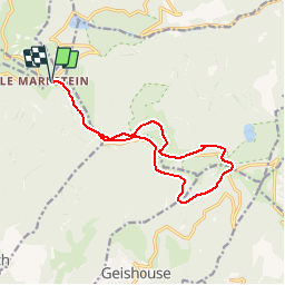
14 km | 19,8 km-effort
4h 45min
![](https://static1.geolcdn.com/siteimages/upload/files/16400158638029165_repeat_loop_refresh_sync_direction_icon.png)
Oui
![Randonnée Marche Linthal - Tour de la grande Vallée de Munster (refuge du Hilsen - Munster) - Photo](https://media.geolcdn.com/t/375/260/ext.jpg?maxdim=2&url=https%3A%2F%2Fservices.sitytrail.com%2FGeolivesWS%2FDownloadMedia.ashx%3FTrailID%3D173094%26Media%3D14636_4.jpg)
![Marche Marche](https://static1.geolcdn.com/sitytour/trail-icons/101.png)
Tour de la grande Vallée de Munster (refuge du Hilsen - Munster)
Marche
Difficile
(1)
Linthal,
Grand Est,
Haut-Rhin,
France
![](/images/other/stat-length.png)
18,1 km | 24 km-effort
5h 0min
![](https://static1.geolcdn.com/siteimages/upload/files/16400158638029165_repeat_loop_refresh_sync_direction_icon.png)
Non
![Randonnée A pied Lautenbachzell - Parking Bellevue - Hundsrucken - Markstein - Photo](https://media.geolcdn.com/t/375/260/ext.jpg?maxdim=2&url=https%3A%2F%2Fstatic1.geolcdn.com%2Fsiteimages%2Fupload%2Ffiles%2F1545311037marcheuse_200dpi.jpg)
![A pied A pied](https://static1.geolcdn.com/sitytour/trail-icons/100.png)
Parking Bellevue - Hundsrucken - Markstein
A pied
Moyen
(1)
Lautenbachzell,
Grand Est,
Haut-Rhin,
France
![](/images/other/stat-length.png)
9,4 km | 13 km-effort
Inconnu
![](https://static1.geolcdn.com/siteimages/upload/files/16400158638029165_repeat_loop_refresh_sync_direction_icon.png)
Oui
![Randonnée V.T.T. Metzeral - Breitfirst - Petit Ballon - Col de Firstplan - Wintzenheim - Photo](https://media.geolcdn.com/t/375/260/ext.jpg?maxdim=2&url=https%3A%2F%2Fstatic1.geolcdn.com%2Fsiteimages%2Fupload%2Ffiles%2F1524743154velo.jpg)
![V.T.T. V.T.T.](https://static1.geolcdn.com/sitytour/trail-icons/202.png)
Breitfirst - Petit Ballon - Col de Firstplan - Wintzenheim
V.T.T.
Moyen
(1)
Metzeral,
Grand Est,
Haut-Rhin,
France
![](/images/other/stat-length.png)
38 km | 52 km-effort
3h 11min
![](https://static1.geolcdn.com/siteimages/upload/files/16400158638029165_repeat_loop_refresh_sync_direction_icon.png)
Non
![Randonnée Marche Oderen - trek alsacien (1ère étape) - Photo](https://media.geolcdn.com/t/375/260/ext.jpg?maxdim=2&url=https%3A%2F%2Fmedia.geolcdn.com%2Ff%2F787fe892-71a8-4daf-8eb0-6ad69c3ebb22.jpg)
![Marche Marche](https://static1.geolcdn.com/sitytour/trail-icons/101.png)
trek alsacien (1ère étape)
Marche
Moyen
Oderen,
Grand Est,
Haut-Rhin,
France
![](/images/other/stat-length.png)
9,2 km | 18,1 km-effort
4h 0min
![](https://static1.geolcdn.com/siteimages/upload/files/16400158638029165_repeat_loop_refresh_sync_direction_icon.png)
Non
![Randonnée Marche Metzeral - 24 04 14 autour d’Uffrain - Photo](https://media.geolcdn.com/t/375/260/ext.jpg?maxdim=2&url=https%3A%2F%2Fmedia.geolcdn.com%2Ff%2F5d272a7d-046b-44ac-82c1-096c8c22e6f1.jpg)
![Marche Marche](https://static1.geolcdn.com/sitytour/trail-icons/101.png)
24 04 14 autour d’Uffrain
Marche
Metzeral,
Grand Est,
Haut-Rhin,
France
![](/images/other/stat-length.png)
70 km | 83 km-effort
3h 45min
![](https://static1.geolcdn.com/siteimages/upload/files/16400158638029165_repeat_loop_refresh_sync_direction_icon.png)
Non
![Randonnée Marche Ranspach - Rando des Marcheurs 20/07/2023 - Photo](https://media.geolcdn.com/t/375/260/ext.jpg?maxdim=2&url=https%3A%2F%2Fmedia.geolcdn.com%2Ff%2Fe65497d0-16d3-4e63-993c-c9f6fe260f85.jpg)
![Marche Marche](https://static1.geolcdn.com/sitytour/trail-icons/101.png)
Rando des Marcheurs 20/07/2023
Marche
Très difficile
Ranspach,
Grand Est,
Haut-Rhin,
France
![](/images/other/stat-length.png)
23 km | 38 km-effort
5h 31min
![](https://static1.geolcdn.com/siteimages/upload/files/16400158638029165_repeat_loop_refresh_sync_direction_icon.png)
Oui
![Randonnée Marche Oderen - Trek alsacien (2ème boucle, Odin) - Photo](https://media.geolcdn.com/t/375/260/ext.jpg?maxdim=2&url=https%3A%2F%2Fmedia.geolcdn.com%2Ff%2Fdddd2487-4fb8-4cef-bf36-6235f5cea729.jpg)
![Marche Marche](https://static1.geolcdn.com/sitytour/trail-icons/101.png)
Trek alsacien (2ème boucle, Odin)
Marche
Moyen
Oderen,
Grand Est,
Haut-Rhin,
France
![](/images/other/stat-length.png)
8,5 km | 12,9 km-effort
2h 56min
![](https://static1.geolcdn.com/siteimages/upload/files/16400158638029165_repeat_loop_refresh_sync_direction_icon.png)
Oui
![Randonnée Marche Oderen - Parking rue Vontay à Oderen - Baerenberg - Gare de Kruth - Laffe - Abri Strass Hiesel et retour - Photo](https://media.geolcdn.com/t/375/260/ext.jpg?maxdim=2&url=https%3A%2F%2Fstatic1.geolcdn.com%2Fsiteimages%2Fupload%2Ffiles%2F1553511878bg_sport_marche.png)
![Marche Marche](https://static1.geolcdn.com/sitytour/trail-icons/101.png)
Parking rue Vontay à Oderen - Baerenberg - Gare de Kruth - Laffe - Abri Stras...
Marche
Moyen
(1)
Oderen,
Grand Est,
Haut-Rhin,
France
![](/images/other/stat-length.png)
7,9 km | 11,7 km-effort
2h 39min
![](https://static1.geolcdn.com/siteimages/upload/files/16400158638029165_repeat_loop_refresh_sync_direction_icon.png)
Oui