![](/images/other/stat-length.png)
![Randonnée Marche Boeschepe - Cordillère de Flandre jour 2 - Photo](https://media.geolcdn.com/t/1900/400/ext.pjpeg?maxdim=2&url=https%3A%2F%2Fstatic1.geolcdn.com%2Fsiteimages%2Fupload%2Ffiles%2F1553511878bg_sport_marche.png)
Cordillère de Flandre jour 2
Randonneur Club Marcquois
RCM ... l'esprit rando à vélo et à pied !
![Longueur](/images/other/stat-length.png)
Longueur
22 km
![Altitude max](https://static1.geolcdn.com/siteimages/upload/files/1508320355ic_sort_altitude_max_24dp.png)
Altitude max
162 m
![Dénivelé positif](https://static1.geolcdn.com/siteimages/upload/files/1508320355ic_sort_den_pos_24dp.png)
Dénivelé positif
458 m
![Km-Effort](/images/other/stat-length.png)
Km-Effort
28 km
![Altitude min](https://static1.geolcdn.com/siteimages/upload/files/1508320355ic_sort_altitude_min_24dp.png)
Altitude min
43 m
![Dénivelé négatif](https://static1.geolcdn.com/siteimages/upload/files/1508320355ic_sort_den_neg_24dp.png)
Dénivelé négatif
444 m
![Boucle](https://static1.geolcdn.com/siteimages/upload/files/16400158638029165_repeat_loop_refresh_sync_direction_icon.png)
Boucle
Non
Date de création :
2018-10-12 16:39:39.528
Dernière modification :
2023-08-02 10:25:16.199
![Marche](https://static1.geolcdn.com/sitytour/trail-icons/101.png)
--
Difficulté : Moyen
![Scannez ce code QR pour ouvrir la randonnée dans l'application SityTrail](https://capi.geolives.com/qq0zvz2zws4bq2lad0pu/sitytour/trails/2013189/qr.png?size=200)
Application GPS de randonnée GRATUITE
À propos
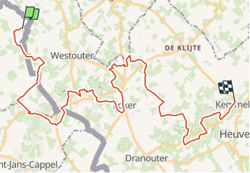
Randonnée Marche de 22 km à découvrir à Hauts-de-France, Nord, Boeschepe. Cette randonnée est proposée par Randonneur Club Marcquois.
Description
Deuxième partie de cette "aventure" : traversée des Monts !
Localisation
Pays :
France
Région :
Hauts-de-France
Département/Province :
Nord
Commune :
Boeschepe
Localité :
Unknown
Départ:(Dec)
Départ:(UTM)
480409 ; 5628381 (31U) N.
Commentaires
Randonnées à proximité
![Randonnée Marche Heuvelland - Monts Rouge et Noir - Photo](https://media.geolcdn.com/t/375/260/00f0cdf9-629e-4b2f-b8bc-5c314a6f710b.jpg&format=jpg&maxdim=2)
![Marche Marche](https://static1.geolcdn.com/sitytour/trail-icons/101.png)
Monts Rouge et Noir
Marche
Difficile
(1)
Heuvelland,
Flandre,
Flandre-Occidentale,
Belgique
![](/images/other/stat-length.png)
24 km | 30 km-effort
5h 27min
![](https://static1.geolcdn.com/siteimages/upload/files/16400158638029165_repeat_loop_refresh_sync_direction_icon.png)
Oui
![Randonnée Marche Berthen - Autour du monastère - Godewaersvelde - Photo](https://media.geolcdn.com/t/375/260/ext.jpg?maxdim=2&url=https%3A%2F%2Fservices.sitytrail.com%2FGeolivesWS%2FDownloadMedia.ashx%3FTrailID%3D111182%26Media%3D6625_1.jpg)
![Marche Marche](https://static1.geolcdn.com/sitytour/trail-icons/101.png)
Autour du monastère - Godewaersvelde
Marche
Difficile
(4)
Berthen,
Hauts-de-France,
Nord,
France
![](/images/other/stat-length.png)
11,8 km | 15,6 km-effort
3h 0min
![](https://static1.geolcdn.com/siteimages/upload/files/16400158638029165_repeat_loop_refresh_sync_direction_icon.png)
Oui
![Randonnée Marche Heuvelland - Loker - Le Mont Rouge - Photo](https://media.geolcdn.com/t/375/260/ext.jpg?maxdim=2&url=https%3A%2F%2Fservices.sitytrail.com%2FGeolivesWS%2FDownloadMedia.ashx%3FTrailID%3D106138%26Media%3D10379_6.jpg)
![Marche Marche](https://static1.geolcdn.com/sitytour/trail-icons/101.png)
Loker - Le Mont Rouge
Marche
Moyen
(3)
Heuvelland,
Flandre,
Flandre-Occidentale,
Belgique
![](/images/other/stat-length.png)
8,7 km | 10,8 km-effort
2h 19min
![](https://static1.geolcdn.com/siteimages/upload/files/16400158638029165_repeat_loop_refresh_sync_direction_icon.png)
Oui
![Randonnée A pied Heuvelland - Tweebergen wandelroute - Photo](https://media.geolcdn.com/t/375/260/5ebabc26-e95b-4a58-8ae1-ac851bf88f60.jpeg&format=jpg&maxdim=2)
![A pied A pied](https://static1.geolcdn.com/sitytour/trail-icons/100.png)
Tweebergen wandelroute
A pied
Facile
Heuvelland,
Flandre,
Flandre-Occidentale,
Belgique
![](/images/other/stat-length.png)
7,3 km | 9 km-effort
2h 2min
![](https://static1.geolcdn.com/siteimages/upload/files/16400158638029165_repeat_loop_refresh_sync_direction_icon.png)
Oui
![Randonnée Marche Heuvelland - Westouter langs tweetermen - Photo](https://media.geolcdn.com/t/375/260/ext.jpg?maxdim=2&url=https%3A%2F%2Fstatic1.geolcdn.com%2Fsiteimages%2Fupload%2Ffiles%2F1553511878bg_sport_marche.png)
![Marche Marche](https://static1.geolcdn.com/sitytour/trail-icons/101.png)
Westouter langs tweetermen
Marche
Difficile
(1)
Heuvelland,
Flandre,
Flandre-Occidentale,
Belgique
![](/images/other/stat-length.png)
7,5 km | 9,1 km-effort
2h 4min
![](https://static1.geolcdn.com/siteimages/upload/files/16400158638029165_repeat_loop_refresh_sync_direction_icon.png)
Oui
![Randonnée Marche Saint-Jans-Cappel - sentier des jacynthes - Photo](https://media.geolcdn.com/t/375/260/ext.jpg?maxdim=2&url=https%3A%2F%2Fstatic1.geolcdn.com%2Fsiteimages%2Fupload%2Ffiles%2F1553511878bg_sport_marche.png)
![Marche Marche](https://static1.geolcdn.com/sitytour/trail-icons/101.png)
sentier des jacynthes
Marche
Moyen
(1)
Saint-Jans-Cappel,
Hauts-de-France,
Nord,
France
![](/images/other/stat-length.png)
7,3 km | 9,2 km-effort
2h 1min
![](https://static1.geolcdn.com/siteimages/upload/files/16400158638029165_repeat_loop_refresh_sync_direction_icon.png)
Oui
![Randonnée Marche Heuvelland - Dranouter 12,3 km - Photo](https://media.geolcdn.com/t/375/260/ab62849d-d2cc-4c63-a20f-7ad369b5fc0f.jpg&format=jpg&maxdim=2)
![Marche Marche](https://static1.geolcdn.com/sitytour/trail-icons/101.png)
Dranouter 12,3 km
Marche
Facile
Heuvelland,
Flandre,
Flandre-Occidentale,
Belgique
![](/images/other/stat-length.png)
12,4 km | 14,5 km-effort
3h 32min
![](https://static1.geolcdn.com/siteimages/upload/files/16400158638029165_repeat_loop_refresh_sync_direction_icon.png)
Oui
![Randonnée Marche Boeschepe - Boeschepe - Photo](https://media.geolcdn.com/t/375/260/6c0906d5-5117-4202-927a-8c802fc11963.jpg&format=jpg&maxdim=2)
![Marche Marche](https://static1.geolcdn.com/sitytour/trail-icons/101.png)
Boeschepe
Marche
Difficile
Boeschepe,
Hauts-de-France,
Nord,
France
![](/images/other/stat-length.png)
10,6 km | 13 km-effort
2h 26min
![](https://static1.geolcdn.com/siteimages/upload/files/16400158638029165_repeat_loop_refresh_sync_direction_icon.png)
Non
![Randonnée A pied Poperinge - Helleketelbos - Photo](https://media.geolcdn.com/t/375/260/0c8cf86c-730c-4042-b9e4-e508bb684d2d.jpeg&format=jpg&maxdim=2)
![A pied A pied](https://static1.geolcdn.com/sitytour/trail-icons/100.png)
Helleketelbos
A pied
Facile
Poperinge,
Flandre,
Flandre-Occidentale,
Belgique
![](/images/other/stat-length.png)
10,8 km | 12,5 km-effort
2h 49min
![](https://static1.geolcdn.com/siteimages/upload/files/16400158638029165_repeat_loop_refresh_sync_direction_icon.png)
Oui