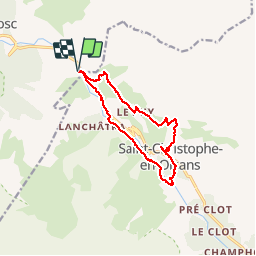
![](/images/other/stat-length.png)
![Randonnée Marche Les Deux Alpes - BOUCLE DU VENEON - Photo](https://media.geolcdn.com/t/1900/400/fb72e059-97b0-4c6d-b32f-a72bcc6ce0d2.jpg&format=pjpeg&maxdim=2)
BOUCLE DU VENEON
floup6138
Utilisateur
![Longueur](/images/other/stat-length.png)
![Altitude max](https://static1.geolcdn.com/siteimages/upload/files/1508320355ic_sort_altitude_max_24dp.png)
![Dénivelé positif](https://static1.geolcdn.com/siteimages/upload/files/1508320355ic_sort_den_pos_24dp.png)
![Km-Effort](/images/other/stat-length.png)
![Altitude min](https://static1.geolcdn.com/siteimages/upload/files/1508320355ic_sort_altitude_min_24dp.png)
![Dénivelé négatif](https://static1.geolcdn.com/siteimages/upload/files/1508320355ic_sort_den_neg_24dp.png)
![Boucle](https://static1.geolcdn.com/siteimages/upload/files/16400158638029165_repeat_loop_refresh_sync_direction_icon.png)
![Marche](https://static1.geolcdn.com/sitytour/trail-icons/101.png)
5h09
Difficulté : Difficile
![Scannez ce code QR pour ouvrir la randonnée dans l'application SityTrail](https://capi.geolives.com/qq0zvz2zws4bq2lad0pu/sitytour/trails/2012311/qr.png?size=200)
Application GPS de randonnée GRATUITE
À propos
Randonnée Marche de 12,5 km à découvrir à Auvergne-Rhône-Alpes, Isère, Les Deux Alpes. Cette randonnée est proposée par floup6138.
Description
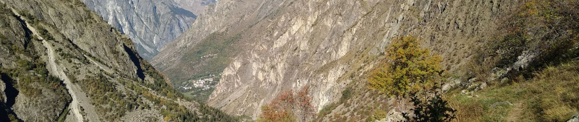
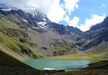
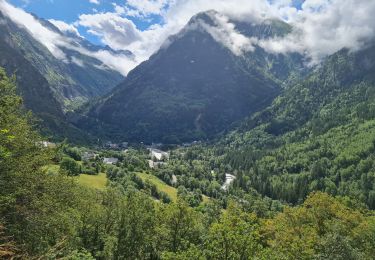
Belle randonnée montagnarde bien balisée.Des le démarrage montée prononcée durée 2 petites heures. passages un peu délicats. Beaux paysages encaissés.
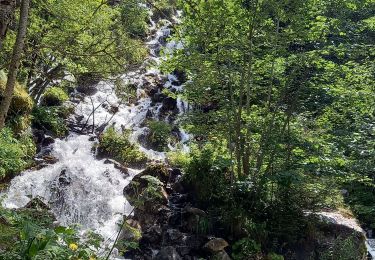
le détour vers le moulin vaut la peine.
le retour est plus délicat beaucoup de pierriers à ne pas faire par temps humide.
Localisation
Commentaires
Randonnées à proximité
![Randonnée Marche Les Deux Alpes - Lac Lauvitel depuis Venosc - Photo](https://media.geolcdn.com/t/375/260/c143dd5b-9bc9-4aa4-a71f-cc60077c341b.jpg&format=jpg&maxdim=2)
![Marche Marche](https://static1.geolcdn.com/sitytour/trail-icons/101.png)
Marche
![](/images/other/stat-length.png)
![](https://static1.geolcdn.com/siteimages/upload/files/16400158638029165_repeat_loop_refresh_sync_direction_icon.png)
![Randonnée Marche Les Deux Alpes - 2020-09-01 Marche Tour de l'Aiguille de Venosc (2 jours) - Photo](https://media.geolcdn.com/t/375/260/34a6bca9-af34-47ba-b9a3-4e85df680f5f.jpg&format=jpg&maxdim=2)
![Marche Marche](https://static1.geolcdn.com/sitytour/trail-icons/101.png)
Marche
![](/images/other/stat-length.png)
![](https://static1.geolcdn.com/siteimages/upload/files/16400158638029165_repeat_loop_refresh_sync_direction_icon.png)
![Randonnée Marche Les Deux Alpes - 2020-09-02 Marche Refuge Muzelle Lac Lauvitel Venosc - Photo](https://media.geolcdn.com/t/375/260/c75743e1-22bd-4dec-87c4-57455ba46347.jpg&format=jpg&maxdim=2)
![Marche Marche](https://static1.geolcdn.com/sitytour/trail-icons/101.png)
Marche
![](/images/other/stat-length.png)
![](https://static1.geolcdn.com/siteimages/upload/files/16400158638029165_repeat_loop_refresh_sync_direction_icon.png)
![Randonnée Marche Les Deux Alpes - 2020-09-01 Marche Venosc Refuge et lac de la Muzelle - Photo](https://media.geolcdn.com/t/375/260/37e869b2-5bed-4bce-85a1-f553a21d8058.jpg&format=jpg&maxdim=2)
![Marche Marche](https://static1.geolcdn.com/sitytour/trail-icons/101.png)
Marche
![](/images/other/stat-length.png)
![](https://static1.geolcdn.com/siteimages/upload/files/16400158638029165_repeat_loop_refresh_sync_direction_icon.png)
![Randonnée Marche Saint-Christophe-en-Oisans - Saint-Christophe-en-Oisans - AR du gîte du Plan du lac au Pont des Granges - 8.4km 240m 4h15 (1h10) - 2015 06 26 - Photo](https://media.geolcdn.com/t/375/260/ext.jpg?maxdim=2&url=https%3A%2F%2Fservices.sitytrail.com%2FGeolivesWS%2FDownloadMedia.ashx%3FTrailID%3D440124%26Media%3Dfix__20150626103336.jpg)
![Marche Marche](https://static1.geolcdn.com/sitytour/trail-icons/101.png)
Marche
![](/images/other/stat-length.png)
![](https://static1.geolcdn.com/siteimages/upload/files/16400158638029165_repeat_loop_refresh_sync_direction_icon.png)
![Randonnée Marche Saint-Christophe-en-Oisans - Saint-Christophe-en-Oisans - de Champhorent au Refuge de La Lavey - 12.9km 570m 5h40 (1h00) - 2015 06 24 - Photo](https://media.geolcdn.com/t/375/260/ext.jpg?maxdim=2&url=https%3A%2F%2Fservices.sitytrail.com%2FGeolivesWS%2FDownloadMedia.ashx%3FTrailID%3D440118%26Media%3Dfix__20150624154321.jpg)
![Marche Marche](https://static1.geolcdn.com/sitytour/trail-icons/101.png)
Marche
![](/images/other/stat-length.png)
![](https://static1.geolcdn.com/siteimages/upload/files/16400158638029165_repeat_loop_refresh_sync_direction_icon.png)
![Randonnée Marche Saint-Christophe-en-Oisans - Saint-Christophe-en-Oisans - Vallon de Lanchâtra - 12.5km 870m 6h05 (1h15) - 2015 06 18 - Photo](https://media.geolcdn.com/t/375/260/ext.jpg?maxdim=2&url=https%3A%2F%2Fservices.sitytrail.com%2FGeolivesWS%2FDownloadMedia.ashx%3FTrailID%3D435411%26Media%3Dfix__20150618132240.jpg)
![Marche Marche](https://static1.geolcdn.com/sitytour/trail-icons/101.png)
Marche
![](/images/other/stat-length.png)
![](https://static1.geolcdn.com/siteimages/upload/files/16400158638029165_repeat_loop_refresh_sync_direction_icon.png)
![Randonnée Marche Les Deux Alpes - Ferraret village du Venosc - Photo](https://media.geolcdn.com/t/375/260/16333e30-f56d-457a-acb2-97a1c2e77d5f.jpg&format=jpg&maxdim=2)
![Marche Marche](https://static1.geolcdn.com/sitytour/trail-icons/101.png)
Marche
![](/images/other/stat-length.png)
![](https://static1.geolcdn.com/siteimages/upload/files/16400158638029165_repeat_loop_refresh_sync_direction_icon.png)
![Randonnée Marche Les Deux Alpes - Venise le lauvitel - Photo](https://media.geolcdn.com/t/375/260/04546b3c-8a5a-43b8-a9f0-58cff4d320ee.jpg&format=jpg&maxdim=2)
![Marche Marche](https://static1.geolcdn.com/sitytour/trail-icons/101.png)
Marche
![](/images/other/stat-length.png)
![](https://static1.geolcdn.com/siteimages/upload/files/16400158638029165_repeat_loop_refresh_sync_direction_icon.png)