Randonnée V.T.T. Beckerich - Pistes_VTT : Beckerich 18 km - Photo

Pistes_VTT : Beckerich 18 km

Randonnées de Visit Luxembourg. GUIDE+

© OpenStreetMap contributors
Longueur
Longueur
19,1 km
Altitude max
Altitude max
415 m
Dénivelé positif
Dénivelé positif
448 m
Km-Effort
Km-Effort  
25 km
Altitude min
Altitude min
289 m
Dénivelé négatif
Dénivelé négatif
454 m
Boucle
Boucle
Oui
Date de création :
2014-12-10 00:00:00.0
Dernière modification :
2014-12-10 00:00:00.0

(1 Avis)

V.T.T.
V.T.T.
--
Difficulté : Inconnu

Scannez ce code QR pour ouvrir la randonnée dans l'application SityTrail

Application GPS de randonnée GRATUITE

Logo SityTrail SityTrail

IGN / Instituts géographiques

Télécharger SityTrail sur l'App Store Télécharger SityTrail sur Google Play

Logo SityTrail SityTrail World

Le monde est à vous

Télécharger SityTrail sur l'App Store Télécharger SityTrail sur Google Play Télécharger SityTrail sur Huawei AppGallery

À propos

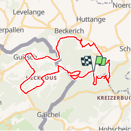
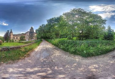
Randonnée V.T.T. de 19,1 km à découvrir à Inconnu, Canton Redange, Beckerich. Cette randonnée est proposée par Visit Luxembourg.

Description

Parcours de VTT 18 km de Beckerich à Hovelange, Schweich, Hobscheid, Leitrange, Heckbus, Gaichel, Guirsch (Arlon) et retour

Profil altimétrique

Localisation

Pays :
Luxembourg
Région :
Inconnu
Département/Province :
Canton Redange
Commune :
Beckerich
Localité :
Unknown
Départ:(Dec)
Départ:(UTM)
709030 ; 5510702 (31U) N.

Commentaires

Veuillez vous connecter pour laisser un commentaire ou une note


1ere utilisation, pronto


Randonnées à proximité

Randonnée Marche Arlon - Clairefontaine - Circuit Natura 2000, des sites qui valent le détour - Lx15 - Photo
Marche
GUIDE+

Marche

Facile
(2)
Arlon, Wallonie, Luxembourg, Belgique
4,1 km | 5,3 km-effort
1h 11min
Oui
Randonnée Marche Arlon - Guirsch, vallée des  moulins - Photo
Marche
ulyse

Marche

Très facile
(1)
Arlon, Wallonie, Luxembourg, Belgique
5,8 km | 7,2 km-effort
1h 33min
Non
Randonnée Marche Habscht - Tunnel Tour - Photo
Marche
Summok

Marche

Moyen
(1)
Habscht, Inconnu, Canton Capellen, Luxembourg
4,2 km | 6,2 km-effort
1h 24min
Oui
Randonnée Marche Arlon - RF-Lu-15 - Une randonnée (trans)frontalière : Clairefontaine - Photo
Marche
PRO

Marche

Très facile
(3)
Arlon, Wallonie, Luxembourg, Belgique
11,1 km | 14,7 km-effort
3h 11min
Oui
Randonnée A pied Arlon - N° 8 - Waltzing-Eischen, balade belgo-luxembourgeoise - Photo
A pied
PRO

A pied

Facile
Arlon, Wallonie, Luxembourg, Belgique
10,3 km | 13 km-effort
2h 57min
Oui
Randonnée A pied Arlon - N° 10 - Clairefontaine : Ermesinde - Photo
A pied
PRO

A pied

Facile
Arlon, Wallonie, Luxembourg, Belgique
4 km | 5,1 km-effort
1h 9min
Oui
Randonnée A pied Arlon - N° 7 - Clairefontaine - L'Eisch - Photo
A pied
PRO

A pied

Facile
Arlon, Wallonie, Luxembourg, Belgique
4,1 km | 5,4 km-effort
1h 13min
Oui
Randonnée A pied Arlon - Guirsch - Village classé - Photo
A pied
PRO

A pied

Facile
Arlon, Wallonie, Luxembourg, Belgique
6,5 km | 8,8 km-effort
1h 59min
Oui
Randonnée A pied Beckerich - La balade transfrontalière à Oberpallen - Photo
A pied
PRO

A pied

Facile
(1)
Beckerich, Inconnu, Canton Redange, Luxembourg
8,2 km | 9,8 km-effort
2h 13min
Oui


Fermer
Mes abonnements