Randonnée Marche Junglinster - Autopedestres : Bourglinster - Photo

Randonnées de Visit Luxembourg. GUIDE+

© OpenStreetMap contributors
Longueur
Longueur
9,6 km
Altitude max
Altitude max
412 m
Dénivelé positif
Dénivelé positif
209 m
Km-Effort
Km-Effort  
12,4 km
Altitude min
Altitude min
308 m
Dénivelé négatif
Dénivelé négatif
206 m
Boucle
Boucle
Oui
Date de création :
2014-12-10 00:00:00.0
Dernière modification :
2014-12-10 00:00:00.0

(0 Avis)

Marche
Marche
--
Difficulté : Inconnu

Scannez ce code QR pour ouvrir la randonnée dans l'application SityTrail

Application GPS de randonnée GRATUITE

Logo SityTrail SityTrail

IGN / Instituts géographiques

Télécharger SityTrail sur l'App Store Télécharger SityTrail sur Google Play

Logo SityTrail SityTrail World

Le monde est à vous

Télécharger SityTrail sur l'App Store Télécharger SityTrail sur Google Play Télécharger SityTrail sur Huawei AppGallery

À propos

Randonnée Marche de 9,6 km à découvrir à Inconnu, Canton Grevenmacher, Junglinster. Cette randonnée est proposée par Visit Luxembourg.

Profil altimétrique

Points d'intérêt

Point d'intérêt Junglinster - Départ - Photo
Visit Luxembourg
JUNGLINSTER 

Localisation

Pays :
Luxembourg
Région :
Inconnu
Département/Province :
Canton Grevenmacher
Commune :
Junglinster
Localité :
Unknown
Départ:(Dec)
Départ:(UTM)
299468 ; 5509329 (32U) N.

Randonnées à proximité

Randonnée Marche Junglinster - Itinérant Luxembourg Jour 3: Graulinster- Echternach - Photo
Marche
GUIDE
chessyca

Marche

Très difficile
Junglinster, Inconnu, Canton Grevenmacher, Luxembourg
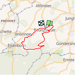
30 km | 37 km-effort
6h 51min
Non
Randonnée A pied Fischbach - Fleche Bleu Fischbach II - Photo
A pied
PRO

A pied

Facile
Fischbach, Inconnu, Canton Mersch, Luxembourg
8,3 km | 11,8 km-effort
2h 40min
Oui
Randonnée A pied Junglinster - J6 Sentier du Plateau - Photo
A pied
PRO

A pied

Facile
Junglinster, Inconnu, Canton Grevenmacher, Luxembourg
8,1 km | 10,2 km-effort
2h 19min
Oui
Randonnée A pied Niederanven - J9 Sentier Biergerkräiz 10,5 km - Photo
A pied
PRO

A pied

Facile
Niederanven, Inconnu, Canton Luxembourg, Luxembourg
8,6 km | 10,7 km-effort
2h 26min
Non
Randonnée A pied Junglinster - Autopedestre Bourglinster - Photo
A pied
PRO

A pied

Facile
Junglinster, Inconnu, Canton Grevenmacher, Luxembourg
9,7 km | 12,5 km-effort
2h 49min
Oui
Randonnée A pied Steinsel - Fleche Bleu Heisdorf - Photo
A pied
PRO

A pied

Facile
Steinsel, Inconnu, Canton Luxembourg, Luxembourg
7,7 km | 10,9 km-effort
2h 28min
Oui
Randonnée Marche Steinsel - Ballade en forêt de Grünewald  - Photo
Marche
dudu42

Marche

Facile
Steinsel, Inconnu, Canton Luxembourg, Luxembourg
5,5 km | 7,6 km-effort
1h 28min
Oui
Randonnée A pied Lorentzweiler - Piste de Santé
A pied
PRO

A pied

Facile
Lorentzweiler, Inconnu, Canton Mersch, Luxembourg
6,6 km | 8,4 km-effort
1h 54min
Non
Randonnée A pied Fischbach - F4 - Photo
A pied
PRO

A pied

Facile
Fischbach, Inconnu, Canton Mersch, Luxembourg
3,5 km | 4,9 km-effort
1h 7min
Non


Fermer
Mes abonnements