![](/images/other/stat-length.png)
![Randonnée Marche Malves-en-Minervois - MALVES_chateau_ ARZENS - Photo](https://media.geolcdn.com/t/1900/400/ext.pjpeg?maxdim=2&url=https%3A%2F%2Fstatic1.geolcdn.com%2Fsiteimages%2Fupload%2Ffiles%2F1553511878bg_sport_marche.png)
MALVES_chateau_ ARZENS
jl_chocho
Utilisateur
![Longueur](/images/other/stat-length.png)
Longueur
32 km
![Altitude max](https://static1.geolcdn.com/siteimages/upload/files/1508320355ic_sort_altitude_max_24dp.png)
Altitude max
229 m
![Dénivelé positif](https://static1.geolcdn.com/siteimages/upload/files/1508320355ic_sort_den_pos_24dp.png)
Dénivelé positif
406 m
![Km-Effort](/images/other/stat-length.png)
Km-Effort
37 km
![Altitude min](https://static1.geolcdn.com/siteimages/upload/files/1508320355ic_sort_altitude_min_24dp.png)
Altitude min
93 m
![Dénivelé négatif](https://static1.geolcdn.com/siteimages/upload/files/1508320355ic_sort_den_neg_24dp.png)
Dénivelé négatif
342 m
![Boucle](https://static1.geolcdn.com/siteimages/upload/files/16400158638029165_repeat_loop_refresh_sync_direction_icon.png)
Boucle
Non
Date de création :
2015-04-11 00:00:00.0
Dernière modification :
2015-04-11 00:00:00.0
![Marche](https://static1.geolcdn.com/sitytour/trail-icons/101.png)
7h55
Difficulté : Moyen
![Scannez ce code QR pour ouvrir la randonnée dans l'application SityTrail](https://capi.geolives.com/qq0zvz2zws4bq2lad0pu/sitytour/trails/200812/qr.png?size=200)
Application GPS de randonnée GRATUITE
À propos
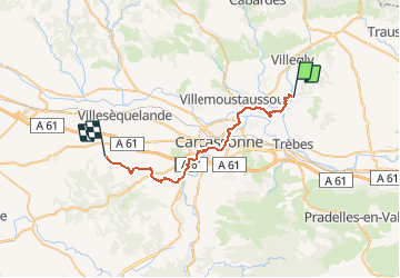
Randonnée Marche de 32 km à découvrir à Occitanie, Aude, Malves-en-Minervois. Cette randonnée est proposée par jl_chocho.
Description
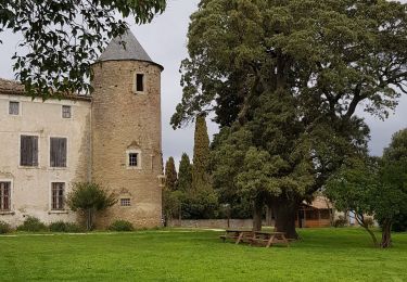
Étape 1 : Château de MALVES puis retrouver le chemin de Compostelle GR78 jusqu'à ARZENS
Départ possible depuis le pont vieux de Carcassonne [GR78]
Localisation
Pays :
France
Région :
Occitanie
Département/Province :
Aude
Commune :
Malves-en-Minervois
Localité :
Unknown
Départ:(Dec)
Départ:(UTM)
454707 ; 4789068 (31T) N.
Commentaires
Randonnées à proximité
![Randonnée V.T.T. Villegly - Cap Nore 2009 60km - Photo](https://media.geolcdn.com/t/375/260/ext.jpg?maxdim=2&url=https%3A%2F%2Fservices.sitytrail.com%2FGeolivesWS%2FDownloadMedia.ashx%3FTrailID%3D103550%26Media%3D5793_6.jpg)
![V.T.T. V.T.T.](https://static1.geolcdn.com/sitytour/trail-icons/202.png)
Cap Nore 2009 60km
V.T.T.
Difficile
(1)
Villegly,
Occitanie,
Aude,
France
![](/images/other/stat-length.png)
61 km | 84 km-effort
5h 0min
![](https://static1.geolcdn.com/siteimages/upload/files/16400158638029165_repeat_loop_refresh_sync_direction_icon.png)
Non
![Randonnée Marche Villegly - Wisigoths - Photo](https://media.geolcdn.com/t/375/260/b23e85ab-30ba-44e7-ba87-562da392561a.jpg&format=jpg&maxdim=2)
![Marche Marche](https://static1.geolcdn.com/sitytour/trail-icons/101.png)
![Randonnée Marche Rustiques - Rustiques - Canet VM - Photo](https://media.geolcdn.com/t/375/260/ext.jpg?maxdim=2&url=https%3A%2F%2Fstatic1.geolcdn.com%2Fsiteimages%2Fupload%2Ffiles%2F1553511878bg_sport_marche.png)
![Marche Marche](https://static1.geolcdn.com/sitytour/trail-icons/101.png)
Rustiques - Canet VM
Marche
Moyen
(1)
Rustiques,
Occitanie,
Aude,
France
![](/images/other/stat-length.png)
7,6 km | 9,1 km-effort
2h 3min
![](https://static1.geolcdn.com/siteimages/upload/files/16400158638029165_repeat_loop_refresh_sync_direction_icon.png)
Oui
![Randonnée A pied Villarzel-Cabardès - Sentier des Wisigoths Villarzel Cabardes - Photo](https://media.geolcdn.com/t/375/260/9be6d263-55a8-4490-a85a-8c17a619cef3.jpg&format=jpg&maxdim=2)
![A pied A pied](https://static1.geolcdn.com/sitytour/trail-icons/100.png)
Sentier des Wisigoths Villarzel Cabardes
A pied
Facile
Villarzel-Cabardès,
Occitanie,
Aude,
France
![](/images/other/stat-length.png)
7,4 km | 8,8 km-effort
1h 59min
![](https://static1.geolcdn.com/siteimages/upload/files/16400158638029165_repeat_loop_refresh_sync_direction_icon.png)
Oui
![Randonnée Marche Villegly - la combe de St Martin à Villegly - Photo](https://media.geolcdn.com/t/375/260/9a0174c9-e7fb-4313-8744-bab2313c03eb.jpg&format=jpg&maxdim=2)
![Marche Marche](https://static1.geolcdn.com/sitytour/trail-icons/101.png)
la combe de St Martin à Villegly
Marche
Facile
Villegly,
Occitanie,
Aude,
France
![](/images/other/stat-length.png)
6,2 km | 7,7 km-effort
2h 45min
![](https://static1.geolcdn.com/siteimages/upload/files/16400158638029165_repeat_loop_refresh_sync_direction_icon.png)
Oui
![Randonnée A pied Villarzel-Cabardès - Sentiers des Wisigoths - Photo](https://media.geolcdn.com/t/375/260/020d7906-1b44-4f82-9bf7-6ef802f93b09.jpeg&format=jpg&maxdim=2)
![A pied A pied](https://static1.geolcdn.com/sitytour/trail-icons/100.png)
Sentiers des Wisigoths
A pied
Facile
Villarzel-Cabardès,
Occitanie,
Aude,
France
![](/images/other/stat-length.png)
4,5 km | 5,5 km-effort
1h 15min
![](https://static1.geolcdn.com/siteimages/upload/files/16400158638029165_repeat_loop_refresh_sync_direction_icon.png)
Non
![Randonnée Marche Villalier - boucle Villalier La Mee les cabanes dans les bois - Photo](https://media.geolcdn.com/t/375/260/972fae87-5c6c-4b20-be31-502366586551.jpg&format=jpg&maxdim=2)
![Marche Marche](https://static1.geolcdn.com/sitytour/trail-icons/101.png)
boucle Villalier La Mee les cabanes dans les bois
Marche
Très facile
Villalier,
Occitanie,
Aude,
France
![](/images/other/stat-length.png)
6,8 km | 8,1 km-effort
1h 58min
![](https://static1.geolcdn.com/siteimages/upload/files/16400158638029165_repeat_loop_refresh_sync_direction_icon.png)
Oui
![Randonnée Vélo de route Trèbes - Trèbes - Photo](https://media.geolcdn.com/t/375/260/7f0ec953-1f3b-4cac-b9b5-6223073e860e.jpg&format=jpg&maxdim=2)
![Vélo de route Vélo de route](https://static1.geolcdn.com/sitytour/trail-icons/201.png)
![Randonnée Marche Malves-en-Minervois - malves villemoustaussou AR - Photo](https://media.geolcdn.com/t/375/260/ext.jpg?maxdim=2&url=https%3A%2F%2Fstatic1.geolcdn.com%2Fsiteimages%2Fupload%2Ffiles%2F1553511878bg_sport_marche.png)
![Marche Marche](https://static1.geolcdn.com/sitytour/trail-icons/101.png)
malves villemoustaussou AR
Marche
Très difficile
(1)
Malves-en-Minervois,
Occitanie,
Aude,
France
![](/images/other/stat-length.png)
17,7 km | 21 km-effort
4h 29min
![](https://static1.geolcdn.com/siteimages/upload/files/16400158638029165_repeat_loop_refresh_sync_direction_icon.png)
Oui