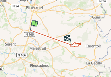
Randonnée Cheval Val d'Oust - ballade a treal - Photo
 franck56140
franck56140

Utilisateur

© OpenStreetMap contributors
Longueur
Longueur
24 km
Altitude max
Altitude max
93 m
Dénivelé positif
Dénivelé positif
271 m
Km-Effort
Km-Effort  
28 km
Altitude min
Altitude min
26 m
Dénivelé négatif
Dénivelé négatif
289 m
Boucle
Boucle
Non
Date de création :
2014-12-10 00:00:00.0
Dernière modification :
2014-12-10 00:00:00.0

(0 Avis)

Cheval
Cheval
1h11
Difficulté : Inconnu

Scannez ce code QR pour ouvrir la randonnée dans l'application SityTrail

Application GPS de randonnée GRATUITE

Logo SityTrail SityTrail

IGN / Instituts géographiques

Télécharger SityTrail sur l'App Store Télécharger SityTrail sur Google Play

Logo SityTrail SityTrail World

Le monde est à vous

Télécharger SityTrail sur l'App Store Télécharger SityTrail sur Google Play Télécharger SityTrail sur Huawei AppGallery

À propos

Randonnée Cheval de 24 km à découvrir à Bretagne, Morbihan, Val d'Oust. Cette randonnée est proposée par franck56140.

Profil altimétrique

Localisation

Pays :
France
Région :
Bretagne
Département/Province :
Morbihan
Commune :
Val d'Oust
Localité :
La Chapelle-Caro
Départ:(Dec)
Départ:(UTM)
543650 ; 5301257 (30T) N.

Randonnées à proximité

Randonnée Marche Saint-Servant - castel 2 - Photo
Marche
bourdet

Marche

Facile
Saint-Servant, Bretagne, Morbihan, France
422 m | 462 m-effort
33min
Oui
Randonnée Marche Guillac - Guillac  - Photo
Marche
motardfou.dgs

Marche

Très facile
Guillac, Bretagne, Morbihan, France
8,8 km | 10,3 km-effort
2h 0min
Oui
Randonnée Marche Sérent - GR_347_AD_04_Serent_St-Servant_20190811 - Photo
Marche
patrickdanilo

Marche

Facile
Sérent, Bretagne, Morbihan, France
12 km | 14,9 km-effort
3h 16min
Non
Randonnée Marche Val d'Oust - 25 1 14  - Photo
Marche
gooogor

Marche

Facile
Val d'Oust, Bretagne, Morbihan, France
21 km | 24 km-effort
3h 8min
Non
Randonnée Marche nordique Val d'Oust - montertrlot - Photo
Marche nordique
rousseau.mich

Marche nordique

Très facile
Val d'Oust, Bretagne, Morbihan, France
11,6 km | 12,7 km-effort
2h 7min
Non
Randonnée Vélo Val d'Oust - Du côté de Josselin - Photo
Vélo
ilur56

Vélo

Facile
(1)
Val d'Oust, Bretagne, Morbihan, France
28 km | 31 km-effort
1h 50min
Non
Randonnée Marche Guillac - Circuit des Croix - Guillac - Photo
Marche
tracegps

Marche

Moyen
Guillac, Bretagne, Morbihan, France
11,8 km | 14,2 km-effort
3h 30min
Oui
Randonnée V.T.T. Val d'Oust - Vélo promenade n°15 - La boucle canal - voie verte - La Chapelle Caro - Photo
V.T.T.
tracegps

V.T.T.

Moyen
Val d'Oust, Bretagne, Morbihan, France
18,1 km | 21 km-effort
1h 30min
Oui
Randonnée V.T.T. Montertelot - Vélo promenade n°3 - Montertelot - Monterrein - Photo
V.T.T.
tracegps

V.T.T.

Moyen
Montertelot, Bretagne, Morbihan, France
28 km | 32 km-effort
3h 0min
Oui


Fermer
Mes abonnements