![](/images/other/stat-length.png)
![Randonnée Marche Vaucresson - GRP CV-IDF 01 - Photo](https://media.geolcdn.com/t/1900/400/5504eb8b-0c97-442f-ae45-fe43074a21fa.jpg&format=pjpeg&maxdim=2)
GRP CV-IDF 01
clalaur
Utilisateur
![Longueur](/images/other/stat-length.png)
Longueur
19,8 km
![Altitude max](https://static1.geolcdn.com/siteimages/upload/files/1508320355ic_sort_altitude_max_24dp.png)
Altitude max
187 m
![Dénivelé positif](https://static1.geolcdn.com/siteimages/upload/files/1508320355ic_sort_den_pos_24dp.png)
Dénivelé positif
451 m
![Km-Effort](/images/other/stat-length.png)
Km-Effort
26 km
![Altitude min](https://static1.geolcdn.com/siteimages/upload/files/1508320355ic_sort_altitude_min_24dp.png)
Altitude min
72 m
![Dénivelé négatif](https://static1.geolcdn.com/siteimages/upload/files/1508320355ic_sort_den_neg_24dp.png)
Dénivelé négatif
483 m
![Boucle](https://static1.geolcdn.com/siteimages/upload/files/16400158638029165_repeat_loop_refresh_sync_direction_icon.png)
Boucle
Non
Date de création :
2018-05-29 14:36:45.306
Dernière modification :
2018-12-29 11:49:39.099
![Marche](https://static1.geolcdn.com/sitytour/trail-icons/101.png)
6h15
Difficulté : Difficile
![Scannez ce code QR pour ouvrir la randonnée dans l'application SityTrail](https://capi.geolives.com/qq0zvz2zws4bq2lad0pu/sitytour/trails/2002044/qr.png?size=200)
Application GPS de randonnée GRATUITE
À propos
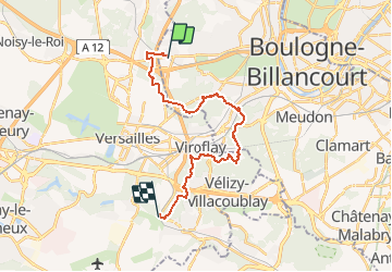
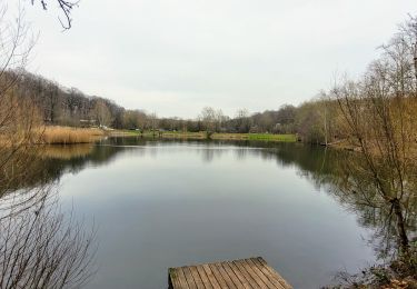
Randonnée Marche de 19,8 km à découvrir à Île-de-France, Hauts-de-Seine, Vaucresson. Cette randonnée est proposée par clalaur.
Description
Ceinture verte de l'Ile de France - Etape 1 sur 16 - De la gare de Vaucresson (L) a la gare de Petit Jouy - Les Loges (RER C)
Localisation
Pays :
France
Région :
Île-de-France
Département/Province :
Hauts-de-Seine
Commune :
Vaucresson
Localité :
Unknown
Départ:(Dec)
Départ:(UTM)
437842 ; 5409673 (31U) N.
Commentaires
Randonnées à proximité
![Randonnée Marche Chaville - Le Sentier des 7 étangs - Photo](https://media.geolcdn.com/t/375/260/ext.jpg?maxdim=2&url=https%3A%2F%2Fservices.sitytrail.com%2FGeolivesWS%2FDownloadMedia.ashx%3FTrailID%3D110203%26Media%3D5435_1.jpg)
![Marche Marche](https://static1.geolcdn.com/sitytour/trail-icons/101.png)
Le Sentier des 7 étangs
Marche
Difficile
(5)
Chaville,
Île-de-France,
Hauts-de-Seine,
France
![](/images/other/stat-length.png)
23 km | 31 km-effort
5h 0min
![](https://static1.geolcdn.com/siteimages/upload/files/16400158638029165_repeat_loop_refresh_sync_direction_icon.png)
Oui
![Randonnée Marche Chaville - GRP CV-IDF 20R Chaville à Vaucresson - Photo](https://media.geolcdn.com/t/375/260/ee9d0d3a-696b-449f-af8b-f1928f5c8b40.jpg&format=jpg&maxdim=2)
![Marche Marche](https://static1.geolcdn.com/sitytour/trail-icons/101.png)
GRP CV-IDF 20R Chaville à Vaucresson
Marche
Moyen
(1)
Chaville,
Île-de-France,
Hauts-de-Seine,
France
![](/images/other/stat-length.png)
8,2 km | 11,1 km-effort
2h 30min
![](https://static1.geolcdn.com/siteimages/upload/files/16400158638029165_repeat_loop_refresh_sync_direction_icon.png)
Non
![Randonnée Marche Bougival - Bougival-Saint-cucufa reel - Photo](https://media.geolcdn.com/t/375/260/f8214235-f5e3-4ba5-8084-044ba7cbf132.jpeg&format=jpg&maxdim=2)
![Marche Marche](https://static1.geolcdn.com/sitytour/trail-icons/101.png)
Bougival-Saint-cucufa reel
Marche
(1)
Bougival,
Île-de-France,
Yvelines,
France
![](/images/other/stat-length.png)
7,7 km | 10,3 km-effort
2h 29min
![](https://static1.geolcdn.com/siteimages/upload/files/16400158638029165_repeat_loop_refresh_sync_direction_icon.png)
Oui
![Randonnée Marche Viroflay - Les 3 Forêts; Meudon, Fausses Reposes et Versailles - Photo](https://media.geolcdn.com/t/375/260/ext.jpg?maxdim=2&url=https%3A%2F%2Fservices.sitytrail.com%2FGeolivesWS%2FDownloadMedia.ashx%3FTrailID%3D110157%26Media%3D5357_1.jpg)
![Marche Marche](https://static1.geolcdn.com/sitytour/trail-icons/101.png)
Les 3 Forêts; Meudon, Fausses Reposes et Versailles
Marche
Difficile
(2)
Viroflay,
Île-de-France,
Yvelines,
France
![](/images/other/stat-length.png)
25 km | 32 km-effort
5h 19min
![](https://static1.geolcdn.com/siteimages/upload/files/16400158638029165_repeat_loop_refresh_sync_direction_icon.png)
Oui
![Randonnée Marche Chaville - Sentier des deux Forêts - Meudon et Verrières - Photo](https://media.geolcdn.com/t/375/260/ext.jpg?maxdim=2&url=https%3A%2F%2Fservices.sitytrail.com%2FGeolivesWS%2FDownloadMedia.ashx%3FTrailID%3D110156%26Media%3D5356_1.jpg)
![Marche Marche](https://static1.geolcdn.com/sitytour/trail-icons/101.png)
Sentier des deux Forêts - Meudon et Verrières
Marche
Difficile
(2)
Chaville,
Île-de-France,
Hauts-de-Seine,
France
![](/images/other/stat-length.png)
23 km | 29 km-effort
5h 0min
![](https://static1.geolcdn.com/siteimages/upload/files/16400158638029165_repeat_loop_refresh_sync_direction_icon.png)
Oui
![Randonnée Marche Versailles - Boucle 19 km Versailles - Meudon + Hangar Y - Photo](https://media.geolcdn.com/t/375/260/0408d080-39aa-4237-87eb-b73399a86f56.jpg&format=jpg&maxdim=2)
![Marche Marche](https://static1.geolcdn.com/sitytour/trail-icons/101.png)
Boucle 19 km Versailles - Meudon + Hangar Y
Marche
Très difficile
Versailles,
Île-de-France,
Yvelines,
France
![](/images/other/stat-length.png)
19,7 km | 25 km-effort
5h 34min
![](https://static1.geolcdn.com/siteimages/upload/files/16400158638029165_repeat_loop_refresh_sync_direction_icon.png)
Oui
![Randonnée Marche Marly-le-Roi - Boucle 25 km Marly le Roi - Chambourcy - Photo](https://media.geolcdn.com/t/375/260/1fe661ec-cb67-45eb-bf71-8b90e4b33a5d.jpg&format=jpg&maxdim=2)
![Marche Marche](https://static1.geolcdn.com/sitytour/trail-icons/101.png)
Boucle 25 km Marly le Roi - Chambourcy
Marche
Moyen
Marly-le-Roi,
Île-de-France,
Yvelines,
France
![](/images/other/stat-length.png)
25 km | 32 km-effort
7h 15min
![](https://static1.geolcdn.com/siteimages/upload/files/16400158638029165_repeat_loop_refresh_sync_direction_icon.png)
Oui
![Randonnée A pied Versailles - Boucle 28 km autour de Versailles - Photo](https://media.geolcdn.com/t/375/260/94e41505-1074-4e90-9565-89ecf7d9db7c.jpg&format=jpg&maxdim=2)
![A pied A pied](https://static1.geolcdn.com/sitytour/trail-icons/100.png)
Boucle 28 km autour de Versailles
A pied
Moyen
Versailles,
Île-de-France,
Yvelines,
France
![](/images/other/stat-length.png)
28 km | 33 km-effort
7h 25min
![](https://static1.geolcdn.com/siteimages/upload/files/16400158638029165_repeat_loop_refresh_sync_direction_icon.png)
Oui
![Randonnée Marche Meudon - Meudon- Chaville - Ville d'Avray - Photo](https://media.geolcdn.com/t/375/260/ab08e3a0-df69-44f9-bf2b-d9ff82133473.jpg&format=jpg&maxdim=2)
![Marche Marche](https://static1.geolcdn.com/sitytour/trail-icons/101.png)
Meudon- Chaville - Ville d'Avray
Marche
Difficile
Meudon,
Île-de-France,
Hauts-de-Seine,
France
![](/images/other/stat-length.png)
28 km | 35 km-effort
6h 3min
![](https://static1.geolcdn.com/siteimages/upload/files/16400158638029165_repeat_loop_refresh_sync_direction_icon.png)
Oui