![](/images/other/stat-length.png)
![Randonnée V.T.T. La Bresse - La Bresse : CIRCUIT VTT N°14 - LE LAC DES CORBEAUX - Photo](https://media.geolcdn.com/t/1900/400/5b42261a-6137-42bc-9b18-9c7e2d8f17ec.jpg&format=pjpeg&maxdim=2)
La Bresse : CIRCUIT VTT N°14 - LE LAC DES CORBEAUX
Alfredy
Utilisateur GUIDE
![Longueur](/images/other/stat-length.png)
Longueur
16,1 km
![Altitude max](https://static1.geolcdn.com/siteimages/upload/files/1508320355ic_sort_altitude_max_24dp.png)
Altitude max
930 m
![Dénivelé positif](https://static1.geolcdn.com/siteimages/upload/files/1508320355ic_sort_den_pos_24dp.png)
Dénivelé positif
420 m
![Km-Effort](/images/other/stat-length.png)
Km-Effort
22 km
![Altitude min](https://static1.geolcdn.com/siteimages/upload/files/1508320355ic_sort_altitude_min_24dp.png)
Altitude min
629 m
![Dénivelé négatif](https://static1.geolcdn.com/siteimages/upload/files/1508320355ic_sort_den_neg_24dp.png)
Dénivelé négatif
420 m
![Boucle](https://static1.geolcdn.com/siteimages/upload/files/16400158638029165_repeat_loop_refresh_sync_direction_icon.png)
Boucle
Oui
Date de création :
2018-05-15 13:04:43.907
Dernière modification :
2018-05-15 13:30:47.981
![V.T.T.](https://static1.geolcdn.com/sitytour/trail-icons/202.png)
1h30
Difficulté : Moyen
![Scannez ce code QR pour ouvrir la randonnée dans l'application SityTrail](https://capi.geolives.com/qq0zvz2zws4bq2lad0pu/sitytour/trails/2001768/qr.png?size=200)
Application GPS de randonnée GRATUITE
À propos
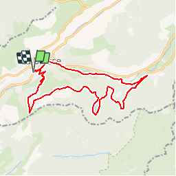
Randonnée V.T.T. de 16,1 km à découvrir à Grand Est, Vosges, La Bresse. Cette randonnée est proposée par Alfredy.
Description
Circuit présenté dans la Carte Hautes-Vosges VTT, disponible à l'Office de Tourisme de La Bresse sur demande. Circuit praticable en VTC.
Localisation
Pays :
France
Région :
Grand Est
Département/Province :
Vosges
Commune :
La Bresse
Localité :
Unknown
Départ:(Dec)
Départ:(UTM)
341348 ; 5318750 (32U) N.
Commentaires
Randonnées à proximité
![Randonnée Marche La Bresse - 2023-04-15 Marche Abri Collet de Etang vers Abri Lac de Blanchemer - Photo](https://media.geolcdn.com/t/375/260/f5705708-8e73-435e-a1e8-28d1d0c03215.jpg&format=jpg&maxdim=2)
![Marche Marche](https://static1.geolcdn.com/sitytour/trail-icons/101.png)
2023-04-15 Marche Abri Collet de Etang vers Abri Lac de Blanchemer
Marche
Moyen
(1)
La Bresse,
Grand Est,
Vosges,
France
![](/images/other/stat-length.png)
22 km | 35 km-effort
7h 51min
![](https://static1.geolcdn.com/siteimages/upload/files/16400158638029165_repeat_loop_refresh_sync_direction_icon.png)
Non
![Randonnée Marche La Bresse - Autour du Lac des Corbeaux - Photo](https://media.geolcdn.com/t/375/260/cc3388d0-b7b4-4b72-bf02-d3b5f6b4e910.jpg&format=jpg&maxdim=2)
![Marche Marche](https://static1.geolcdn.com/sitytour/trail-icons/101.png)
Autour du Lac des Corbeaux
Marche
Moyen
(1)
La Bresse,
Grand Est,
Vosges,
France
![](/images/other/stat-length.png)
3,1 km | 6 km-effort
1h 30min
![](https://static1.geolcdn.com/siteimages/upload/files/16400158638029165_repeat_loop_refresh_sync_direction_icon.png)
Oui
![Randonnée Marche La Bresse - la bresse - le moutier des fées - Photo](https://media.geolcdn.com/t/375/260/8b05ded1-af8a-4cd0-8ffd-c8efb092f1de.jpg&format=jpg&maxdim=2)
![Marche Marche](https://static1.geolcdn.com/sitytour/trail-icons/101.png)
la bresse - le moutier des fées
Marche
Très facile
(1)
La Bresse,
Grand Est,
Vosges,
France
![](/images/other/stat-length.png)
26 km | 36 km-effort
3h 26min
![](https://static1.geolcdn.com/siteimages/upload/files/16400158638029165_repeat_loop_refresh_sync_direction_icon.png)
Non
![Randonnée Marche La Bresse - SityTrail - Le Lac des Corbeaux - La Bresse - Photo](https://media.geolcdn.com/t/375/260/4efcd8bf-8367-405d-962e-dfceb2021e66.jpg&format=jpg&maxdim=2)
![Marche Marche](https://static1.geolcdn.com/sitytour/trail-icons/101.png)
SityTrail - Le Lac des Corbeaux - La Bresse
Marche
Très facile
(1)
La Bresse,
Grand Est,
Vosges,
France
![](/images/other/stat-length.png)
3 km | 6 km-effort
1h 0min
![](https://static1.geolcdn.com/siteimages/upload/files/16400158638029165_repeat_loop_refresh_sync_direction_icon.png)
Oui
![Randonnée Marche La Bresse - lac de Lispach - Photo](https://media.geolcdn.com/t/375/260/ext.jpg?maxdim=2&url=https%3A%2F%2Fservices.sitytrail.com%2FGeolivesWS%2FDownloadMedia.ashx%3FTrailID%3D441673%26Media%3D20150705125536.jpg)
![Marche Marche](https://static1.geolcdn.com/sitytour/trail-icons/101.png)
lac de Lispach
Marche
Facile
(1)
La Bresse,
Grand Est,
Vosges,
France
![](/images/other/stat-length.png)
10,4 km | 14,1 km-effort
4h 6min
![](https://static1.geolcdn.com/siteimages/upload/files/16400158638029165_repeat_loop_refresh_sync_direction_icon.png)
Oui
![Randonnée Marche La Bresse - lac de Lispach - Photo](https://media.geolcdn.com/t/375/260/ext.jpg?maxdim=2&url=https%3A%2F%2Fservices.sitytrail.com%2FGeolivesWS%2FDownloadMedia.ashx%3FTrailID%3D441672%26Media%3D20150705124703.jpg)
![Marche Marche](https://static1.geolcdn.com/sitytour/trail-icons/101.png)
lac de Lispach
Marche
Facile
(3)
La Bresse,
Grand Est,
Vosges,
France
![](/images/other/stat-length.png)
10,4 km | 14,1 km-effort
4h 6min
![](https://static1.geolcdn.com/siteimages/upload/files/16400158638029165_repeat_loop_refresh_sync_direction_icon.png)
Oui
![Randonnée Marche La Bresse - Le Couchetat - Photo](https://media.geolcdn.com/t/375/260/ext.jpg?maxdim=2&url=https%3A%2F%2Fservices.sitytrail.com%2FGeolivesWS%2FDownloadMedia.ashx%3FTrailID%3D441671%26Media%3D20150706110250.jpg)
![Marche Marche](https://static1.geolcdn.com/sitytour/trail-icons/101.png)
Le Couchetat
Marche
Très facile
(2)
La Bresse,
Grand Est,
Vosges,
France
![](/images/other/stat-length.png)
4,8 km | 7,4 km-effort
1h 50min
![](https://static1.geolcdn.com/siteimages/upload/files/16400158638029165_repeat_loop_refresh_sync_direction_icon.png)
Oui
![Randonnée Marche Cornimont - Xoulces _ Grand Ventron _ Vieille Montagne - Photo](https://media.geolcdn.com/t/375/260/ext.jpg?maxdim=2&url=https%3A%2F%2Fservices.sitytrail.com%2FGeolivesWS%2FDownloadMedia.ashx%3FTrailID%3D439822%26Media%3Dfix__20150630145857.jpg)
![Marche Marche](https://static1.geolcdn.com/sitytour/trail-icons/101.png)
Xoulces _ Grand Ventron _ Vieille Montagne
Marche
Moyen
(1)
Cornimont,
Grand Est,
Vosges,
France
![](/images/other/stat-length.png)
15,6 km | 25 km-effort
5h 6min
![](https://static1.geolcdn.com/siteimages/upload/files/16400158638029165_repeat_loop_refresh_sync_direction_icon.png)
Non
![Randonnée V.T.T. La Bresse - randonnée découverte à la Bresse. - Photo](https://media.geolcdn.com/t/375/260/ext.jpg?maxdim=2&url=https%3A%2F%2Fservices.sitytrail.com%2FGeolivesWS%2FDownloadMedia.ashx%3FTrailID%3D435768%26Media%3Dfix__20150620120320.jpg)
![V.T.T. V.T.T.](https://static1.geolcdn.com/sitytour/trail-icons/202.png)
randonnée découverte à la Bresse.
V.T.T.
Facile
(1)
La Bresse,
Grand Est,
Vosges,
France
![](/images/other/stat-length.png)
30 km | 41 km-effort
2h 58min
![](https://static1.geolcdn.com/siteimages/upload/files/16400158638029165_repeat_loop_refresh_sync_direction_icon.png)
Oui