


3,7 km | 4 km-effort
![Randonnée Marche Lyon - [TEST] Fête des lumières à Lyon - Photo](https://media.geolcdn.com/t/1900/400/560949a4-103c-40f8-8858-2d7089db2b2d.jpg&format=pjpeg&maxdim=2)

Utilisateur


Application GPS de randonnée GRATUITE
 SityTrail
IGN / Instituts géographiques
SityTrail World
Le monde est à vous
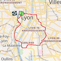
Randonnée Marche de 14,2 km à découvrir à Auvergne-Rhône-Alpes, Métropole de Lyon, Lyon. Cette randonnée est proposée par Benoît BS .
La Fête des Lumières, s'appuie sur la fête religieuse dite fête du 8 décembre, fête de l'immaculée conception, Illuminations ou encore fête de la Vierge Marie. C'est devenu une manifestation populaire, initiée par la ville de Lyon en 1989, qui se tient chaque année pendant quatre jours autour du 8 décembre, date traditionnelle de l'événement, à Lyon (France).
![Randonnée Marche Lyon - [TEST] Fête des lumières à Lyon - Photo 1](https://media.geolcdn.com/t/2048/auto/560949a4-103c-40f8-8858-2d7089db2b2d.jpg&format=jpg&maxdim=0 "Randonnée Marche Lyon - [TEST] Fête des lumières à Lyon - Photo 1")
![Randonnée Marche Lyon - [TEST] Fête des lumières à Lyon - Photo 2](https://media.geolcdn.com/t/2048/auto/2b5be074-c18b-4282-857e-8cf0632a69d0.jpg&format=jpg&maxdim=0 "Randonnée Marche Lyon - [TEST] Fête des lumières à Lyon - Photo 2")
![Randonnée Marche Lyon - [TEST] Fête des lumières à Lyon - Photo 3](https://media.geolcdn.com/t/2048/auto/720fa645-6b66-4f9f-bb68-2785bc32ee93.jpg&format=jpg&maxdim=0 "Randonnée Marche Lyon - [TEST] Fête des lumières à Lyon - Photo 3")
![Randonnée Marche Lyon - [TEST] Fête des lumières à Lyon - Photo 4](https://media.geolcdn.com/t/2048/auto/28905154-f79b-433b-a18b-b20aefd9861a.jpg&format=jpg&maxdim=0 "Randonnée Marche Lyon - [TEST] Fête des lumières à Lyon - Photo 4")
![Randonnée Marche Lyon - [TEST] Fête des lumières à Lyon - Photo 5](https://media.geolcdn.com/t/2048/auto/8dc9f6dd-ba30-43c3-9958-3948b3b966d3.jpg&format=jpg&maxdim=0 "Randonnée Marche Lyon - [TEST] Fête des lumières à Lyon - Photo 5")
![Randonnée Marche Lyon - [TEST] Fête des lumières à Lyon - Photo 6](https://media.geolcdn.com/t/2048/auto/a7bf05fd-6059-4ccb-91f2-ec8990ecf65d.jpg&format=jpg&maxdim=0 "Randonnée Marche Lyon - [TEST] Fête des lumières à Lyon - Photo 6")
![Randonnée Marche Lyon - [TEST] Fête des lumières à Lyon - Photo 7](https://media.geolcdn.com/t/2048/auto/f888f305-a6b6-499b-9f42-de17b2854c19.jpg&format=jpg&maxdim=0 "Randonnée Marche Lyon - [TEST] Fête des lumières à Lyon - Photo 7")
![Randonnée Marche Lyon - [TEST] Fête des lumières à Lyon - Photo 8](https://media.geolcdn.com/t/2048/auto/40fb0f70-8019-4cbc-b39a-17786cb6bbe1.jpg&format=jpg&maxdim=0 "Randonnée Marche Lyon - [TEST] Fête des lumières à Lyon - Photo 8")
![Randonnée Marche Lyon - [TEST] Fête des lumières à Lyon - Photo 9](https://media.geolcdn.com/t/2048/auto/d651b13a-dae1-41e3-9525-a661b8395a8b.JPG&format=jpg&maxdim=0 "Randonnée Marche Lyon - [TEST] Fête des lumières à Lyon - Photo 9")
![Randonnée Marche Lyon - [TEST] Fête des lumières à Lyon - Photo 10](https://media.geolcdn.com/t/2048/auto/f819f23c-ebe7-4163-a366-35cdb6c897d6.jpg&format=jpg&maxdim=0 "Randonnée Marche Lyon - [TEST] Fête des lumières à Lyon - Photo 10")
![Randonnée Marche Lyon - [TEST] Fête des lumières à Lyon - Photo 11](https://media.geolcdn.com/t/2048/auto/0459d1a6-54a5-4f46-b7b1-642c3fe74e53.jpg&format=jpg&maxdim=0 "Randonnée Marche Lyon - [TEST] Fête des lumières à Lyon - Photo 11")
![Randonnée Marche Lyon - [TEST] Fête des lumières à Lyon - Photo 12](https://media.geolcdn.com/t/2048/auto/0d708923-9ee2-4aab-8e90-eed15b5e8a38.jpg&format=jpg&maxdim=0 "Randonnée Marche Lyon - [TEST] Fête des lumières à Lyon - Photo 12")
![Randonnée Marche Lyon - [TEST] Fête des lumières à Lyon - Photo 13](https://media.geolcdn.com/t/2048/auto/5e9914f9-895d-418e-a7d0-8a3f94780bf9.jpg&format=jpg&maxdim=0 "Randonnée Marche Lyon - [TEST] Fête des lumières à Lyon - Photo 13")
![Randonnée Marche Lyon - [TEST] Fête des lumières à Lyon - Photo 14](https://media.geolcdn.com/t/2048/auto/8a7e0518-02bb-4faf-a68d-2a28fe9bb0a8.jpg&format=jpg&maxdim=0 "Randonnée Marche Lyon - [TEST] Fête des lumières à Lyon - Photo 14")
![Randonnée Marche Lyon - [TEST] Fête des lumières à Lyon - Photo 15](https://media.geolcdn.com/t/2048/auto/bf03b1d5-ca4a-4c8b-abe5-607c3abcfa72.jpg&format=jpg&maxdim=0 "Randonnée Marche Lyon - [TEST] Fête des lumières à Lyon - Photo 15")
![Randonnée Marche Lyon - [TEST] Fête des lumières à Lyon - Photo 16](https://media.geolcdn.com/t/2048/auto/197a3778-379f-4550-ac13-3a40d4951e6b.jpg&format=jpg&maxdim=0 "Randonnée Marche Lyon - [TEST] Fête des lumières à Lyon - Photo 16")
Marche

V.T.T.

Marche

Marche
Marche

V.T.T.

Marche
Marche
Marche