![](/images/other/stat-length.png)
![Randonnée Autre activité Veuzain-sur-Loire - canot-camping Loire - Photo](https://media.geolcdn.com/t/1900/400/ext.pjpeg?maxdim=2&url=https%3A%2F%2Fstatic1.geolcdn.com%2Fsiteimages%2Fupload%2Ffiles%2F1545311037marcheuse_200dpi.jpg)
canot-camping Loire
ritchi
Utilisateur
![Longueur](/images/other/stat-length.png)
Longueur
66 km
![Altitude max](https://static1.geolcdn.com/siteimages/upload/files/1508320355ic_sort_altitude_max_24dp.png)
Altitude max
66 m
![Dénivelé positif](https://static1.geolcdn.com/siteimages/upload/files/1508320355ic_sort_den_pos_24dp.png)
Dénivelé positif
69 m
![Km-Effort](/images/other/stat-length.png)
Km-Effort
67 km
![Altitude min](https://static1.geolcdn.com/siteimages/upload/files/1508320355ic_sort_altitude_min_24dp.png)
Altitude min
36 m
![Dénivelé négatif](https://static1.geolcdn.com/siteimages/upload/files/1508320355ic_sort_den_neg_24dp.png)
Dénivelé négatif
91 m
![Boucle](https://static1.geolcdn.com/siteimages/upload/files/16400158638029165_repeat_loop_refresh_sync_direction_icon.png)
Boucle
Non
Date de création :
2014-12-10 00:00:00.0
Dernière modification :
2014-12-10 00:00:00.0
![Autre activité](https://static1.geolcdn.com/sitytour/trail-icons/900.png)
5m
Difficulté : Très facile
![Scannez ce code QR pour ouvrir la randonnée dans l'application SityTrail](https://capi.geolives.com/qq0zvz2zws4bq2lad0pu/sitytour/trails/199707/qr.png?size=200)
Application GPS de randonnée GRATUITE
À propos
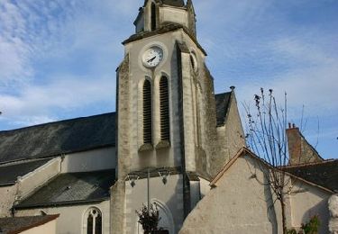
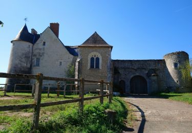
Randonnée Autre activité de 66 km à découvrir à Centre-Val de Loire, Loir-et-Cher, Veuzain-sur-Loire. Cette randonnée est proposée par ritchi.
Description
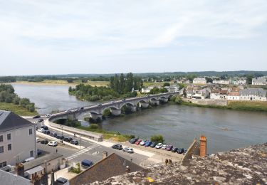
Chaumont-Langeais en 2 jours avec un débit de 800m3/s.
Etape 1 de 31 km entre Chaumont et MontLouis
Etape 2 Montlouis - Langeais
Attention au Pont wilson à Tours passage sous l'arche extrème gauche avec train de vagues
Localisation
Pays :
France
Région :
Centre-Val de Loire
Département/Province :
Loir-et-Cher
Commune :
Veuzain-sur-Loire
Localité :
Onzain
Départ:(Dec)
Départ:(UTM)
363883 ; 5260776 (31T) N.
Commentaires
Randonnées à proximité
![Randonnée V.T.T. Valloire-sur-Cisse - Vignoble et Cisse - Chouzy sur Cisse - Photo](https://media.geolcdn.com/t/375/260/ext.jpg?maxdim=2&url=https%3A%2F%2Fservices.sitytrail.com%2FGeolivesWS%2FDownloadMedia.ashx%3FTrailID%3D317889%26Media%3D17292_6.jpg)
![V.T.T. V.T.T.](https://static1.geolcdn.com/sitytour/trail-icons/202.png)
Vignoble et Cisse - Chouzy sur Cisse
V.T.T.
Moyen
(2)
Valloire-sur-Cisse,
Centre-Val de Loire,
Loir-et-Cher,
France
![](/images/other/stat-length.png)
18,8 km | 21 km-effort
1h 30min
![](https://static1.geolcdn.com/siteimages/upload/files/16400158638029165_repeat_loop_refresh_sync_direction_icon.png)
Oui
![Randonnée Marche Veuzain-sur-Loire - Onzain - GR3 Chouzy-sur-Cisse GR353B - 24.7km 250m 5h45 (30mn) - 2022 09 18 - Photo](https://media.geolcdn.com/t/375/260/7be7e1ff-5ac8-493b-b202-21094f0fc660.jpg&format=jpg&maxdim=2)
![Marche Marche](https://static1.geolcdn.com/sitytour/trail-icons/101.png)
Onzain - GR3 Chouzy-sur-Cisse GR353B - 24.7km 250m 5h45 (30mn) - 2022 09 18
Marche
Moyen
Veuzain-sur-Loire,
Centre-Val de Loire,
Loir-et-Cher,
France
![](/images/other/stat-length.png)
25 km | 28 km-effort
5h 45min
![](https://static1.geolcdn.com/siteimages/upload/files/16400158638029165_repeat_loop_refresh_sync_direction_icon.png)
Oui
![Randonnée Cyclotourisme Candé-sur-Beuvron - E Candé sur Beuvron à Montlouis sur Loire - Photo](https://media.geolcdn.com/t/375/260/7739fb38-bd79-4cd9-a9de-f14cf05cda61.jpg&format=jpg&maxdim=2)
![Cyclotourisme Cyclotourisme](https://static1.geolcdn.com/sitytour/trail-icons/204.png)
E Candé sur Beuvron à Montlouis sur Loire
Cyclotourisme
Facile
Candé-sur-Beuvron,
Centre-Val de Loire,
Loir-et-Cher,
France
![](/images/other/stat-length.png)
47 km | 52 km-effort
3h 26min
![](https://static1.geolcdn.com/siteimages/upload/files/16400158638029165_repeat_loop_refresh_sync_direction_icon.png)
Non
![Randonnée Marche Veuzain-sur-Loire - onzain - Photo](https://media.geolcdn.com/t/375/260/ext.jpg?maxdim=2&url=https%3A%2F%2Fstatic1.geolcdn.com%2Fsiteimages%2Fupload%2Ffiles%2F1553511878bg_sport_marche.png)
![Marche Marche](https://static1.geolcdn.com/sitytour/trail-icons/101.png)
onzain
Marche
Moyen
Veuzain-sur-Loire,
Centre-Val de Loire,
Loir-et-Cher,
France
![](/images/other/stat-length.png)
5,6 km | 6,5 km-effort
1h 25min
![](https://static1.geolcdn.com/siteimages/upload/files/16400158638029165_repeat_loop_refresh_sync_direction_icon.png)
Oui
![Randonnée V.T.T. Rilly-sur-Loire - Balade du soir - Photo](https://media.geolcdn.com/t/375/260/ext.jpg?maxdim=2&url=https%3A%2F%2Fstatic1.geolcdn.com%2Fsiteimages%2Fupload%2Ffiles%2F1524743154velo.jpg)
![V.T.T. V.T.T.](https://static1.geolcdn.com/sitytour/trail-icons/202.png)
Balade du soir
V.T.T.
Facile
Rilly-sur-Loire,
Centre-Val de Loire,
Loir-et-Cher,
France
![](/images/other/stat-length.png)
3,3 km | 3,6 km-effort
29min
![](https://static1.geolcdn.com/siteimages/upload/files/16400158638029165_repeat_loop_refresh_sync_direction_icon.png)
Non
![Randonnée Vélo de route Chaumont-sur-Loire - 2 - Photo](https://media.geolcdn.com/t/375/260/ext.jpg?maxdim=2&url=https%3A%2F%2Fstatic1.geolcdn.com%2Fsiteimages%2Fupload%2Ffiles%2F1524743154velo.jpg)
![Vélo de route Vélo de route](https://static1.geolcdn.com/sitytour/trail-icons/201.png)
2
Vélo de route
Moyen
Chaumont-sur-Loire,
Centre-Val de Loire,
Loir-et-Cher,
France
![](/images/other/stat-length.png)
62 km | 68 km-effort
3h 27min
![](https://static1.geolcdn.com/siteimages/upload/files/16400158638029165_repeat_loop_refresh_sync_direction_icon.png)
Non
![Randonnée Marche Veuzain-sur-Loire - veuzain - Photo](https://media.geolcdn.com/t/375/260/ext.jpg?maxdim=2&url=https%3A%2F%2Fstatic1.geolcdn.com%2Fsiteimages%2Fupload%2Ffiles%2F1553511878bg_sport_marche.png)
![Marche Marche](https://static1.geolcdn.com/sitytour/trail-icons/101.png)
veuzain
Marche
Difficile
Veuzain-sur-Loire,
Centre-Val de Loire,
Loir-et-Cher,
France
![](/images/other/stat-length.png)
10,9 km | 12 km-effort
2h 44min
![](https://static1.geolcdn.com/siteimages/upload/files/16400158638029165_repeat_loop_refresh_sync_direction_icon.png)
Oui
![Randonnée A pied Chaumont-sur-Loire - chaumont - Photo](https://media.geolcdn.com/t/375/260/ext.jpg?maxdim=2&url=https%3A%2F%2Fstatic1.geolcdn.com%2Fsiteimages%2Fupload%2Ffiles%2F1545311037marcheuse_200dpi.jpg)
![A pied A pied](https://static1.geolcdn.com/sitytour/trail-icons/100.png)
chaumont
A pied
Très facile
(1)
Chaumont-sur-Loire,
Centre-Val de Loire,
Loir-et-Cher,
France
![](/images/other/stat-length.png)
15,4 km | 17,3 km-effort
Inconnu
![](https://static1.geolcdn.com/siteimages/upload/files/16400158638029165_repeat_loop_refresh_sync_direction_icon.png)
Oui
![Randonnée Marche Valloire-sur-Cisse - chouzy valloires - Photo](https://media.geolcdn.com/t/375/260/ext.jpg?maxdim=2&url=https%3A%2F%2Fstatic1.geolcdn.com%2Fsiteimages%2Fupload%2Ffiles%2F1553511878bg_sport_marche.png)
![Marche Marche](https://static1.geolcdn.com/sitytour/trail-icons/101.png)
chouzy valloires
Marche
Moyen
Valloire-sur-Cisse,
Centre-Val de Loire,
Loir-et-Cher,
France
![](/images/other/stat-length.png)
10,4 km | 11,5 km-effort
2h 36min
![](https://static1.geolcdn.com/siteimages/upload/files/16400158638029165_repeat_loop_refresh_sync_direction_icon.png)
Oui