Randonnée Autre activité Luthern - Luthernbad - Badegg - Niederänzi - Napf - Photo

Luthernbad - Badegg - Niederänzi - Napf

 bayardpaul
bayardpaul

Utilisateur

© OpenStreetMap contributors
Longueur
Longueur
4,9 km
Altitude max
Altitude max
1398 m
Dénivelé positif
Dénivelé positif
556 m
Km-Effort
Km-Effort  
10,6 km
Altitude min
Altitude min
878 m
Dénivelé négatif
Dénivelé négatif
43 m
Boucle
Boucle
Non
Date de création :
2014-12-11 00:00:00.0
Dernière modification :
2014-12-11 00:00:00.0

(0 Avis)

Autre activité
Autre activité
--
Difficulté : Inconnu

Scannez ce code QR pour ouvrir la randonnée dans l'application SityTrail

Application GPS de randonnée GRATUITE

Logo SityTrail SityTrail

IGN / Instituts géographiques

Télécharger SityTrail sur l'App Store Télécharger SityTrail sur Google Play

Logo SityTrail SityTrail World

Le monde est à vous

Télécharger SityTrail sur l'App Store Télécharger SityTrail sur Google Play Télécharger SityTrail sur Huawei AppGallery

À propos

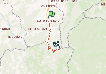
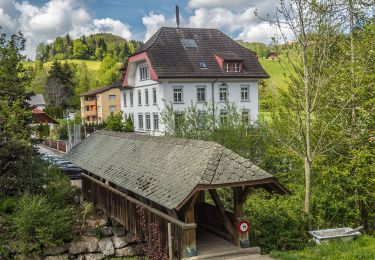
Randonnée Autre activité de 4,9 km à découvrir à Lucerne, Inconnu, Luthern. Cette randonnée est proposée par bayardpaul.

Description

Volmer Louise
Breitigasse 39
8610 Uster
01 940 55 06

Profil altimétrique

Localisation

Pays :
Suisse
Région :
Lucerne
Département/Province :
Inconnu
Commune :
Luthern
Localité :
Unknown
Départ:(Dec)
Départ:(UTM)
418335 ; 5208752 (32T) N.

Randonnées à proximité

Randonnée A pied Hergiswil bei Willisau - Chanzelsagen - Hübeli - Photo
A pied
PRO

A pied

Facile
Hergiswil bei Willisau, Lucerne, Inconnu, Suisse
4,1 km | 6,7 km-effort
1h 31min
Non
Randonnée A pied Trub - Stächelegg - Holzwäge - Photo
A pied
PRO

A pied

Facile
Trub, Berne, Arrondissement administratif de l'Emmental, Suisse
3,8 km | 5,3 km-effort
1h 11min
Non
Randonnée A pied Hergiswil bei Willisau - St.Joder - Gmeinalp - Photo
A pied
PRO

A pied

Facile
Hergiswil bei Willisau, Lucerne, Inconnu, Suisse
3,6 km | 5,8 km-effort
1h 18min
Non
Randonnée A pied Luthern - LUTRUN - Photo
A pied
PRO

A pied

Facile
Luthern, Lucerne, Inconnu, Suisse
8,1 km | 9 km-effort
2h 3min
Non
Randonnée A pied Luthern - Luthern - Under Schluck - Photo
A pied
PRO

A pied

Facile
Luthern, Lucerne, Inconnu, Suisse
3,8 km | 6,1 km-effort
1h 23min
Non
Randonnée A pied Romoos - Wolf - Oberänzi - Photo
A pied
PRO

A pied

Facile
Romoos, Lucerne, Inconnu, Suisse
4,4 km | 6,5 km-effort
1h 29min
Non
Randonnée A pied Romoos - Drachslis - Ober Länggrat - Photo
A pied
PRO

A pied

Facile
Romoos, Lucerne, Inconnu, Suisse
3,3 km | 7 km-effort
1h 35min
Non
Randonnée A pied Menznau - Chanzelsagen - Oberlehn - Photo
A pied
PRO

A pied

Facile
Menznau, Lucerne, Inconnu, Suisse
4,2 km | 5,5 km-effort
1h 15min
Non
Randonnée A pied Luthern - Luthern - Birbaum - Photo
A pied
PRO

A pied

Facile
Luthern, Lucerne, Inconnu, Suisse
3,5 km | 6,3 km-effort
1h 25min
Non


Fermer
Mes abonnements