![](/images/other/stat-length.png)
![Randonnée Autre activité Sempach - Anfahrt ab Autobahnausfahrt Sempach - Photo](https://media.geolcdn.com/t/1900/400/ext.pjpeg?maxdim=2&url=https%3A%2F%2Fstatic1.geolcdn.com%2Fsiteimages%2Fupload%2Ffiles%2F1545311037marcheuse_200dpi.jpg)
Anfahrt ab Autobahnausfahrt Sempach
fritz
Utilisateur
![Longueur](/images/other/stat-length.png)
![Altitude max](https://static1.geolcdn.com/siteimages/upload/files/1508320355ic_sort_altitude_max_24dp.png)
![Dénivelé positif](https://static1.geolcdn.com/siteimages/upload/files/1508320355ic_sort_den_pos_24dp.png)
![Km-Effort](/images/other/stat-length.png)
![Altitude min](https://static1.geolcdn.com/siteimages/upload/files/1508320355ic_sort_altitude_min_24dp.png)
![Dénivelé négatif](https://static1.geolcdn.com/siteimages/upload/files/1508320355ic_sort_den_neg_24dp.png)
![Boucle](https://static1.geolcdn.com/siteimages/upload/files/16400158638029165_repeat_loop_refresh_sync_direction_icon.png)
![Autre activité](https://static1.geolcdn.com/sitytour/trail-icons/900.png)
--
Difficulté : Inconnu
![Scannez ce code QR pour ouvrir la randonnée dans l'application SityTrail](https://capi.geolives.com/qq0zvz2zws4bq2lad0pu/sitytour/trails/19710/qr.png?size=200)
Application GPS de randonnée GRATUITE
À propos
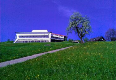
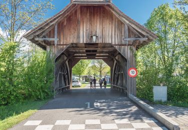
Randonnée Autre activité de 9,4 km à découvrir à Lucerne, Inconnu, Sempach. Cette randonnée est proposée par fritz.
Description
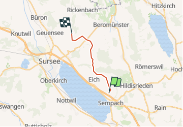
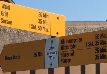
Die Anfahrt ist ab Sempach mit der rot gestrichelten Linie markiert. Sie fahren Richtung Vogelsang-Waldi-Rickenbach. ca. 1 km nach Waldi sehen Sie links die ehemaligen Käserei Holdern. Dort biegen Sie links ab und folgen den Holzwegweisern Richtung Diegenstal oder den kleinen Wegweisern "Bauer Fritz". Sie können auf Wunsch die Karte auch näher zoomen.
Localisation
Commentaires
Randonnées à proximité
![Randonnée A pied Beromünster - Neudorf - Unter Blosenberg - Photo](https://media.geolcdn.com/t/375/260/a9e8306d-f111-4dfc-9c67-cc4e4df5163f.jpeg&format=jpg&maxdim=2)
![A pied A pied](https://static1.geolcdn.com/sitytour/trail-icons/100.png)
A pied
![](/images/other/stat-length.png)
![](https://static1.geolcdn.com/siteimages/upload/files/16400158638029165_repeat_loop_refresh_sync_direction_icon.png)
![Randonnée A pied Nottwil - Sempachersee-Moosweg - Photo](https://media.geolcdn.com/t/375/260/5b43a39d-2789-497e-af40-998ef39b5ba7.jpeg&format=jpg&maxdim=2)
![A pied A pied](https://static1.geolcdn.com/sitytour/trail-icons/100.png)
A pied
![](/images/other/stat-length.png)
![](https://static1.geolcdn.com/siteimages/upload/files/16400158638029165_repeat_loop_refresh_sync_direction_icon.png)
![Randonnée A pied Römerswil - Hildisrieden - Römerswil - Photo](https://media.geolcdn.com/t/375/260/0a4147b2-cbff-44df-a56a-c1941275f40c.jpeg&format=jpg&maxdim=2)
![A pied A pied](https://static1.geolcdn.com/sitytour/trail-icons/100.png)
A pied
![](/images/other/stat-length.png)
![](https://static1.geolcdn.com/siteimages/upload/files/16400158638029165_repeat_loop_refresh_sync_direction_icon.png)
![Randonnée A pied Beromünster - Morentaler Wald - Blosenberg - Photo](https://media.geolcdn.com/t/375/260/a9e8306d-f111-4dfc-9c67-cc4e4df5163f.jpeg&format=jpg&maxdim=2)
![A pied A pied](https://static1.geolcdn.com/sitytour/trail-icons/100.png)
A pied
![](/images/other/stat-length.png)
![](https://static1.geolcdn.com/siteimages/upload/files/16400158638029165_repeat_loop_refresh_sync_direction_icon.png)
![Randonnée A pied Beromünster - Waldhaus - Älmeringen -Gormund - Photo](https://media.geolcdn.com/t/375/260/c9cebd51-7d26-4f59-8a42-112d0a21e44a.jpeg&format=jpg&maxdim=2)
![A pied A pied](https://static1.geolcdn.com/sitytour/trail-icons/100.png)
A pied
![](/images/other/stat-length.png)
![](https://static1.geolcdn.com/siteimages/upload/files/16400158638029165_repeat_loop_refresh_sync_direction_icon.png)
![Randonnée A pied Neuenkirch - Adelwil - Bärtiswil - Photo](https://media.geolcdn.com/t/375/260/d286582e-e630-4410-99ae-955497ecf71b.jpeg&format=jpg&maxdim=2)
![A pied A pied](https://static1.geolcdn.com/sitytour/trail-icons/100.png)
A pied
![](/images/other/stat-length.png)
![](https://static1.geolcdn.com/siteimages/upload/files/16400158638029165_repeat_loop_refresh_sync_direction_icon.png)
![Randonnée A pied Nottwil - Nottwil - Sempach (Vogelwarte) - Photo](https://media.geolcdn.com/t/375/260/06c2aee0-d9ed-4bae-a21f-a68a34b0e075.jpeg&format=jpg&maxdim=2)
![A pied A pied](https://static1.geolcdn.com/sitytour/trail-icons/100.png)
A pied
![](/images/other/stat-length.png)
![](https://static1.geolcdn.com/siteimages/upload/files/16400158638029165_repeat_loop_refresh_sync_direction_icon.png)
![Randonnée A pied Schenkon - Schenkon - Eich - Photo](https://media.geolcdn.com/t/375/260/274c9e7b-5c2d-4d8b-8988-66feb5aa3fce.jpeg&format=jpg&maxdim=2)
![A pied A pied](https://static1.geolcdn.com/sitytour/trail-icons/100.png)
![Randonnée A pied Neuenkirch - Niklaus Wolf Weg - Photo](https://media.geolcdn.com/t/375/260/566428a6-7061-4778-a877-ae993341de8d.jpeg&format=jpg&maxdim=2)
![A pied A pied](https://static1.geolcdn.com/sitytour/trail-icons/100.png)
A pied
![](/images/other/stat-length.png)
![](https://static1.geolcdn.com/siteimages/upload/files/16400158638029165_repeat_loop_refresh_sync_direction_icon.png)