![](/images/other/stat-length.png)
![Randonnée Autre activité Neckertal - AR / schönengrund - jakobsweg - herisau - Photo](https://media.geolcdn.com/t/1900/400/ext.pjpeg?maxdim=2&url=https%3A%2F%2Fstatic1.geolcdn.com%2Fsiteimages%2Fupload%2Ffiles%2F1545311037marcheuse_200dpi.jpg)
AR / schönengrund - jakobsweg - herisau
denisewanderige
Utilisateur
![Longueur](/images/other/stat-length.png)
Longueur
12 km
![Altitude max](https://static1.geolcdn.com/siteimages/upload/files/1508320355ic_sort_altitude_max_24dp.png)
Altitude max
1092 m
![Dénivelé positif](https://static1.geolcdn.com/siteimages/upload/files/1508320355ic_sort_den_pos_24dp.png)
Dénivelé positif
447 m
![Km-Effort](/images/other/stat-length.png)
Km-Effort
18,3 km
![Altitude min](https://static1.geolcdn.com/siteimages/upload/files/1508320355ic_sort_altitude_min_24dp.png)
Altitude min
729 m
![Dénivelé négatif](https://static1.geolcdn.com/siteimages/upload/files/1508320355ic_sort_den_neg_24dp.png)
Dénivelé négatif
540 m
![Boucle](https://static1.geolcdn.com/siteimages/upload/files/16400158638029165_repeat_loop_refresh_sync_direction_icon.png)
Boucle
Non
Date de création :
2014-12-11 00:00:00.0
Dernière modification :
2014-12-11 00:00:00.0
![Autre activité](https://static1.geolcdn.com/sitytour/trail-icons/900.png)
--
Difficulté : Inconnu
![Scannez ce code QR pour ouvrir la randonnée dans l'application SityTrail](https://capi.geolives.com/qq0zvz2zws4bq2lad0pu/sitytour/trails/19478/qr.png?size=200)
Application GPS de randonnée GRATUITE
À propos
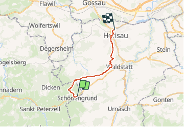
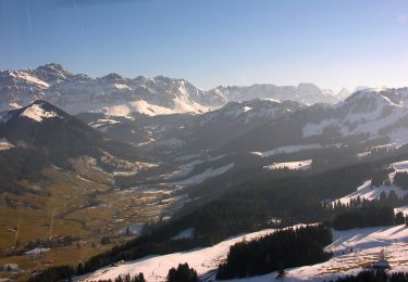
Randonnée Autre activité de 12 km à découvrir à Saint-Gall, Wahlkreis Toggenburg, Neckertal. Cette randonnée est proposée par denisewanderige.
Description
Details (Wanderbeschrieb, Fotos, Dauer, Links, usw.) siehe unter:
http://www.wanderige.ch/wanderige_toure/2007/herisau/herisau.htm
Localisation
Pays :
Suisse
Région :
Saint-Gall
Département/Province :
Wahlkreis Toggenburg
Commune :
Neckertal
Localité :
Unknown
Départ:(Dec)
Départ:(UTM)
517145 ; 5241771 (32T) N.
Commentaires
Randonnées à proximité
![Randonnée A pied Hemberg - Rundweg H7 - Photo](https://media.geolcdn.com/t/375/260/db7482db-6c68-43e1-adde-d745a5c432f7.jpeg&format=jpg&maxdim=2)
![A pied A pied](https://static1.geolcdn.com/sitytour/trail-icons/100.png)
Rundweg H7
A pied
Facile
Hemberg,
Saint-Gall,
Wahlkreis Toggenburg,
Suisse
![](/images/other/stat-length.png)
4,7 km | 7,2 km-effort
1h 38min
![](https://static1.geolcdn.com/siteimages/upload/files/16400158638029165_repeat_loop_refresh_sync_direction_icon.png)
Oui
![Randonnée A pied Hemberg - Rundweg H6 - Photo](https://media.geolcdn.com/t/375/260/db7482db-6c68-43e1-adde-d745a5c432f7.jpeg&format=jpg&maxdim=2)
![A pied A pied](https://static1.geolcdn.com/sitytour/trail-icons/100.png)
Rundweg H6
A pied
Facile
Hemberg,
Saint-Gall,
Wahlkreis Toggenburg,
Suisse
![](/images/other/stat-length.png)
7,5 km | 11 km-effort
2h 29min
![](https://static1.geolcdn.com/siteimages/upload/files/16400158638029165_repeat_loop_refresh_sync_direction_icon.png)
Oui
![Randonnée A pied Hemberg - Rundweg H5 - Photo](https://media.geolcdn.com/t/375/260/db7482db-6c68-43e1-adde-d745a5c432f7.jpeg&format=jpg&maxdim=2)
![A pied A pied](https://static1.geolcdn.com/sitytour/trail-icons/100.png)
Rundweg H5
A pied
Facile
Hemberg,
Saint-Gall,
Wahlkreis Toggenburg,
Suisse
![](/images/other/stat-length.png)
6,3 km | 9,6 km-effort
2h 10min
![](https://static1.geolcdn.com/siteimages/upload/files/16400158638029165_repeat_loop_refresh_sync_direction_icon.png)
Oui
![Randonnée A pied Hemberg - Rundweg H2 - Photo](https://media.geolcdn.com/t/375/260/55b5ec6b-979b-442c-b39e-664b657d587b.jpeg&format=jpg&maxdim=2)
![A pied A pied](https://static1.geolcdn.com/sitytour/trail-icons/100.png)
Rundweg H2
A pied
Facile
Hemberg,
Saint-Gall,
Wahlkreis Toggenburg,
Suisse
![](/images/other/stat-length.png)
3,6 km | 5,1 km-effort
1h 8min
![](https://static1.geolcdn.com/siteimages/upload/files/16400158638029165_repeat_loop_refresh_sync_direction_icon.png)
Oui
![Randonnée A pied Neckertal - Ziegelhütte-Ebersol - Photo](https://media.geolcdn.com/t/375/260/a9387f16-27d5-457e-8472-d100254310b3.jpeg&format=jpg&maxdim=2)
![A pied A pied](https://static1.geolcdn.com/sitytour/trail-icons/100.png)
Ziegelhütte-Ebersol
A pied
Facile
Neckertal,
Saint-Gall,
Wahlkreis Toggenburg,
Suisse
![](/images/other/stat-length.png)
3,9 km | 7 km-effort
1h 35min
![](https://static1.geolcdn.com/siteimages/upload/files/16400158638029165_repeat_loop_refresh_sync_direction_icon.png)
Non
![Randonnée A pied Hemberg - Rundweg H3 - Photo](https://media.geolcdn.com/t/375/260/db7482db-6c68-43e1-adde-d745a5c432f7.jpeg&format=jpg&maxdim=2)
![A pied A pied](https://static1.geolcdn.com/sitytour/trail-icons/100.png)
Rundweg H3
A pied
Facile
Hemberg,
Saint-Gall,
Wahlkreis Toggenburg,
Suisse
![](/images/other/stat-length.png)
3,5 km | 4,8 km-effort
1h 5min
![](https://static1.geolcdn.com/siteimages/upload/files/16400158638029165_repeat_loop_refresh_sync_direction_icon.png)
Oui
![Randonnée A pied Urnäsch - CH-Schönau-Berggasthaus Hochhamm-Parkplatz Hochhamm - Photo](https://media.geolcdn.com/t/375/260/029ba061-1981-4534-b5d6-9d170dcffbbc.jpeg&format=jpg&maxdim=2)
![A pied A pied](https://static1.geolcdn.com/sitytour/trail-icons/100.png)
CH-Schönau-Berggasthaus Hochhamm-Parkplatz Hochhamm
A pied
Facile
Urnäsch,
Appenzell Rhodes-Extérieures,
Hinterland,
Suisse
![](/images/other/stat-length.png)
3,1 km | 6,1 km-effort
1h 23min
![](https://static1.geolcdn.com/siteimages/upload/files/16400158638029165_repeat_loop_refresh_sync_direction_icon.png)
Non
![Randonnée A pied Urnäsch - Grüenau-Herrendürren - Photo](https://media.geolcdn.com/t/375/260/ext.jpg?maxdim=2&url=https%3A%2F%2Fstatic1.geolcdn.com%2Fsiteimages%2Fupload%2Ffiles%2F1545311037marcheuse_200dpi.jpg)
![A pied A pied](https://static1.geolcdn.com/sitytour/trail-icons/100.png)
Grüenau-Herrendürren
A pied
Facile
Urnäsch,
Appenzell Rhodes-Extérieures,
Hinterland,
Suisse
![](/images/other/stat-length.png)
3,3 km | 7 km-effort
1h 35min
![](https://static1.geolcdn.com/siteimages/upload/files/16400158638029165_repeat_loop_refresh_sync_direction_icon.png)
Non
![Randonnée A pied Hemberg - Rundweg H4 - Photo](https://media.geolcdn.com/t/375/260/ext.jpg?maxdim=2&url=https%3A%2F%2Fstatic1.geolcdn.com%2Fsiteimages%2Fupload%2Ffiles%2F1545311037marcheuse_200dpi.jpg)
![A pied A pied](https://static1.geolcdn.com/sitytour/trail-icons/100.png)
Rundweg H4
A pied
Facile
Hemberg,
Saint-Gall,
Wahlkreis Toggenburg,
Suisse
![](/images/other/stat-length.png)
4,5 km | 7 km-effort
1h 35min
![](https://static1.geolcdn.com/siteimages/upload/files/16400158638029165_repeat_loop_refresh_sync_direction_icon.png)
Oui