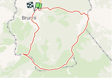
![](/images/other/stat-length.png)
![Randonnée Autre activité Alpthal - SZ / brunni - holzegg - furggelenstock - brunni - Photo](https://media.geolcdn.com/t/1900/400/ext.pjpeg?maxdim=2&url=https%3A%2F%2Fstatic1.geolcdn.com%2Fsiteimages%2Fupload%2Ffiles%2F1545311037marcheuse_200dpi.jpg)
SZ / brunni - holzegg - furggelenstock - brunni
denisewanderige
Utilisateur
![Longueur](/images/other/stat-length.png)
Longueur
9,5 km
![Altitude max](https://static1.geolcdn.com/siteimages/upload/files/1508320355ic_sort_altitude_max_24dp.png)
Altitude max
1646 m
![Dénivelé positif](https://static1.geolcdn.com/siteimages/upload/files/1508320355ic_sort_den_pos_24dp.png)
Dénivelé positif
616 m
![Km-Effort](/images/other/stat-length.png)
Km-Effort
17,7 km
![Altitude min](https://static1.geolcdn.com/siteimages/upload/files/1508320355ic_sort_altitude_min_24dp.png)
Altitude min
1092 m
![Dénivelé négatif](https://static1.geolcdn.com/siteimages/upload/files/1508320355ic_sort_den_neg_24dp.png)
Dénivelé négatif
620 m
![Boucle](https://static1.geolcdn.com/siteimages/upload/files/16400158638029165_repeat_loop_refresh_sync_direction_icon.png)
Boucle
Oui
Date de création :
2014-12-11 00:00:00.0
Dernière modification :
2014-12-11 00:00:00.0
![Autre activité](https://static1.geolcdn.com/sitytour/trail-icons/900.png)
--
Difficulté : Inconnu
![Scannez ce code QR pour ouvrir la randonnée dans l'application SityTrail](https://capi.geolives.com/qq0zvz2zws4bq2lad0pu/sitytour/trails/19428/qr.png?size=200)
Application GPS de randonnée GRATUITE
À propos
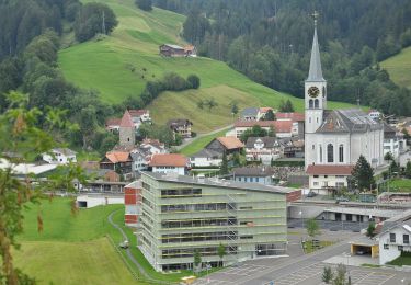
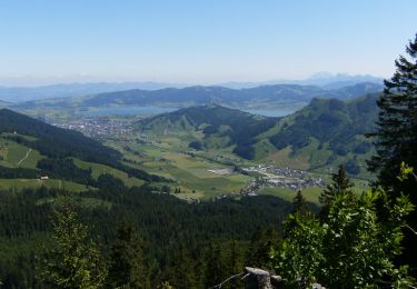
Randonnée Autre activité de 9,5 km à découvrir à Schwyz, Schwyz, Alpthal. Cette randonnée est proposée par denisewanderige.
Description
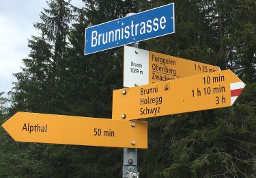
Details (Wanderbeschrieb, Fotos, Dauer, Links, usw.) siehe unter:
http://www.wanderige.ch/wanderige_toure/2003-2005/furggelenstock/furggelenstock.htm
Localisation
Pays :
Suisse
Région :
Schwyz
Département/Province :
Schwyz
Commune :
Alpthal
Localité :
Unknown
Départ:(Dec)
Départ:(UTM)
477579 ; 5210147 (32T) N.
Commentaires
Randonnées à proximité
![Randonnée A pied Illgau - Ybriger 7-Egg-Weg - Photo](https://media.geolcdn.com/t/375/260/8172f528-eb65-4b6a-8a63-100cb5cac7df.jpeg&format=jpg&maxdim=2)
![A pied A pied](https://static1.geolcdn.com/sitytour/trail-icons/100.png)
![Randonnée A pied Schwytz - Mythenweg - fixme - Photo](https://media.geolcdn.com/t/375/260/f56a1fb9-d805-45bd-b7b1-990fd6c25121.jpeg&format=jpg&maxdim=2)
![A pied A pied](https://static1.geolcdn.com/sitytour/trail-icons/100.png)
![Randonnée A pied Alpthal - Brunni - Muesliegg - Photo](https://media.geolcdn.com/t/375/260/2e10adc5-9ceb-4566-aa1d-0f02f50f0194.jpeg&format=jpg&maxdim=2)
![A pied A pied](https://static1.geolcdn.com/sitytour/trail-icons/100.png)
Brunni - Muesliegg
A pied
Facile
Alpthal,
Schwyz,
Schwyz,
Suisse
![](/images/other/stat-length.png)
3,5 km | 6,8 km-effort
1h 32min
![](https://static1.geolcdn.com/siteimages/upload/files/16400158638029165_repeat_loop_refresh_sync_direction_icon.png)
Non
![Randonnée A pied Alpthal - Oberdorf - Teuffeli - Photo](https://media.geolcdn.com/t/375/260/dev_0064d5bb-1d55-447f-9407-9151a2d46bcc.jpeg&format=jpg&maxdim=2)
![A pied A pied](https://static1.geolcdn.com/sitytour/trail-icons/100.png)
Oberdorf - Teuffeli
A pied
Facile
Alpthal,
Schwyz,
Schwyz,
Suisse
![](/images/other/stat-length.png)
4,6 km | 6,3 km-effort
1h 25min
![](https://static1.geolcdn.com/siteimages/upload/files/16400158638029165_repeat_loop_refresh_sync_direction_icon.png)
Non
![Randonnée A pied Schwytz - Teuffeli - Brüschrainhöchi - Photo](https://media.geolcdn.com/t/375/260/dev_af76ee8d-7e7a-463f-ae22-eacc551a6bd8.jpeg&format=jpg&maxdim=2)
![A pied A pied](https://static1.geolcdn.com/sitytour/trail-icons/100.png)
Teuffeli - Brüschrainhöchi
A pied
Facile
Schwytz,
Schwyz,
Schwyz,
Suisse
![](/images/other/stat-length.png)
4 km | 6 km-effort
1h 21min
![](https://static1.geolcdn.com/siteimages/upload/files/16400158638029165_repeat_loop_refresh_sync_direction_icon.png)
Non
![Randonnée A pied Alpthal - Malosen - Hagenegg - Photo](https://media.geolcdn.com/t/375/260/ext.jpg?maxdim=2&url=https%3A%2F%2Fstatic1.geolcdn.com%2Fsiteimages%2Fupload%2Ffiles%2F1545311037marcheuse_200dpi.jpg)
![A pied A pied](https://static1.geolcdn.com/sitytour/trail-icons/100.png)
Malosen - Hagenegg
A pied
Facile
Alpthal,
Schwyz,
Schwyz,
Suisse
![](/images/other/stat-length.png)
3,2 km | 7,1 km-effort
1h 36min
![](https://static1.geolcdn.com/siteimages/upload/files/16400158638029165_repeat_loop_refresh_sync_direction_icon.png)
Non
![Randonnée Marche Schwytz - Urschweizer Haute-Route als Strohtour - Photo](https://media.geolcdn.com/t/375/260/ext.jpg?maxdim=2&url=https%3A%2F%2Fstatic1.geolcdn.com%2Fsiteimages%2Fupload%2Ffiles%2F1553511878bg_sport_marche.png)
![Marche Marche](https://static1.geolcdn.com/sitytour/trail-icons/101.png)
Urschweizer Haute-Route als Strohtour
Marche
Très facile
Schwytz,
Schwyz,
Schwyz,
Suisse
![](/images/other/stat-length.png)
12,4 km | 16,3 km-effort
Inconnu
![](https://static1.geolcdn.com/siteimages/upload/files/16400158638029165_repeat_loop_refresh_sync_direction_icon.png)
Non
![Randonnée Marche Schwytz - sf_e6a - Photo](https://media.geolcdn.com/t/375/260/ext.jpg?maxdim=2&url=https%3A%2F%2Fstatic1.geolcdn.com%2Fsiteimages%2Fupload%2Ffiles%2F1553511878bg_sport_marche.png)
![Marche Marche](https://static1.geolcdn.com/sitytour/trail-icons/101.png)
![Randonnée Marche Sattel - sf_e5c - Photo](https://media.geolcdn.com/t/375/260/ext.jpg?maxdim=2&url=https%3A%2F%2Fstatic1.geolcdn.com%2Fsiteimages%2Fupload%2Ffiles%2F1553511878bg_sport_marche.png)
![Marche Marche](https://static1.geolcdn.com/sitytour/trail-icons/101.png)