![](/images/other/stat-length.png)
![Randonnée V.T.T. Courtagnon - La Montagne de Reims- De Courtagnon à Germaine - Photo](https://media.geolcdn.com/t/1900/400/ext.pjpeg?maxdim=2&url=https%3A%2F%2Fservices.sitytrail.com%2FGeolivesWS%2FDownloadMedia.ashx%3FTrailID%3D191596%26Media%3D15230_3.jpg)
La Montagne de Reims- De Courtagnon à Germaine
tracegps
Utilisateur
![Longueur](/images/other/stat-length.png)
Longueur
26 km
![Altitude max](https://static1.geolcdn.com/siteimages/upload/files/1508320355ic_sort_altitude_max_24dp.png)
Altitude max
283 m
![Dénivelé positif](https://static1.geolcdn.com/siteimages/upload/files/1508320355ic_sort_den_pos_24dp.png)
Dénivelé positif
409 m
![Km-Effort](/images/other/stat-length.png)
Km-Effort
31 km
![Altitude min](https://static1.geolcdn.com/siteimages/upload/files/1508320355ic_sort_altitude_min_24dp.png)
Altitude min
150 m
![Dénivelé négatif](https://static1.geolcdn.com/siteimages/upload/files/1508320355ic_sort_den_neg_24dp.png)
Dénivelé négatif
409 m
![Boucle](https://static1.geolcdn.com/siteimages/upload/files/16400158638029165_repeat_loop_refresh_sync_direction_icon.png)
Boucle
Oui
Date de création :
2014-12-10 00:00:00.0
Dernière modification :
2014-12-10 00:00:00.0
![V.T.T.](https://static1.geolcdn.com/sitytour/trail-icons/202.png)
2h15
Difficulté : Difficile
![Scannez ce code QR pour ouvrir la randonnée dans l'application SityTrail](https://capi.geolives.com/qq0zvz2zws4bq2lad0pu/sitytour/trails/191596/qr.png?size=200)
Application GPS de randonnée GRATUITE
À propos
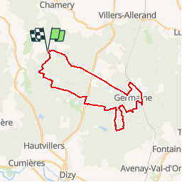
Randonnée V.T.T. de 26 km à découvrir à Grand Est, Marne, Courtagnon. Cette randonnée est proposée par tracegps.
Description
Circuit hétérogène passant par la forêt, les champs, avec des routes forestières roulantes, des coupe-feux marécageux et 100 m à travers les bois hors chemin. Départ de Courtagnon ou de la maison forestière du Cadran sur la route Reims-Epernay.
Localisation
Pays :
France
Région :
Grand Est
Département/Province :
Marne
Commune :
Courtagnon
Localité :
Unknown
Départ:(Dec)
Départ:(UTM)
569130 ; 5443763 (31U) N.
Commentaires
Randonnées à proximité
![Randonnée Marche Sermiers - Sermier La Noelle 8,1 kms environ - Photo](https://media.geolcdn.com/t/375/260/ext.jpg?maxdim=2&url=https%3A%2F%2Fstatic1.geolcdn.com%2Fsiteimages%2Fupload%2Ffiles%2F1553511878bg_sport_marche.png)
![Marche Marche](https://static1.geolcdn.com/sitytour/trail-icons/101.png)
Sermier La Noelle 8,1 kms environ
Marche
Moyen
(1)
Sermiers,
Grand Est,
Marne,
France
![](/images/other/stat-length.png)
8,1 km | 9,4 km-effort
2h 7min
![](https://static1.geolcdn.com/siteimages/upload/files/16400158638029165_repeat_loop_refresh_sync_direction_icon.png)
Oui
![Randonnée Marche Sermiers - SityTrail - parking route d'épernay-version hiver - Photo](https://media.geolcdn.com/t/375/260/ext.jpg?maxdim=2&url=https%3A%2F%2Fstatic1.geolcdn.com%2Fsiteimages%2Fupload%2Ffiles%2F1553511878bg_sport_marche.png)
![Marche Marche](https://static1.geolcdn.com/sitytour/trail-icons/101.png)
SityTrail - parking route d'épernay-version hiver
Marche
Moyen
(1)
Sermiers,
Grand Est,
Marne,
France
![](/images/other/stat-length.png)
8,8 km | 9,9 km-effort
1h 35min
![](https://static1.geolcdn.com/siteimages/upload/files/16400158638029165_repeat_loop_refresh_sync_direction_icon.png)
Oui
![Randonnée Marche Écueil - Ecueil - Chamery 01 11 2012 - Photo](https://media.geolcdn.com/t/375/260/ext.jpg?maxdim=2&url=https%3A%2F%2Fservices.sitytrail.com%2FGeolivesWS%2FDownloadMedia.ashx%3FTrailID%3D160802%26Media%3D20121101151401.jpeg)
![Marche Marche](https://static1.geolcdn.com/sitytour/trail-icons/101.png)
Ecueil - Chamery 01 11 2012
Marche
Facile
Écueil,
Grand Est,
Marne,
France
![](/images/other/stat-length.png)
5,4 km | 7,1 km-effort
Inconnu
![](https://static1.geolcdn.com/siteimages/upload/files/16400158638029165_repeat_loop_refresh_sync_direction_icon.png)
Oui
![Randonnée Marche Courtagnon - Coutagnon - Photo](https://media.geolcdn.com/t/375/260/cdc3f1e5-1dfe-4efe-a1c7-d62cb784a241.jpg&format=jpg&maxdim=2)
![Marche Marche](https://static1.geolcdn.com/sitytour/trail-icons/101.png)
![Randonnée Marche Cormoyeux - hautvillers 24km - Photo](https://media.geolcdn.com/t/375/260/ext.jpg?maxdim=2&url=https%3A%2F%2Fstatic1.geolcdn.com%2Fsiteimages%2Fupload%2Ffiles%2F1553511878bg_sport_marche.png)
![Marche Marche](https://static1.geolcdn.com/sitytour/trail-icons/101.png)
hautvillers 24km
Marche
Très facile
Cormoyeux,
Grand Est,
Marne,
France
![](/images/other/stat-length.png)
23 km | 31 km-effort
6h 33min
![](https://static1.geolcdn.com/siteimages/upload/files/16400158638029165_repeat_loop_refresh_sync_direction_icon.png)
Oui
![Randonnée sport Saint-Imoges - St Imoges - Epernay - Photo](https://media.geolcdn.com/t/375/260/21d4ce20-e215-410e-9131-664439727c9a.jpg&format=jpg&maxdim=2)
St Imoges - Epernay
sport
Très facile
Saint-Imoges,
Grand Est,
Marne,
France
![](/images/other/stat-length.png)
17,4 km | 20 km-effort
Inconnu
![](https://static1.geolcdn.com/siteimages/upload/files/16400158638029165_repeat_loop_refresh_sync_direction_icon.png)
Non
![Randonnée Marche Pourcy - pourcy - Photo](https://media.geolcdn.com/t/375/260/ext.jpg?maxdim=2&url=https%3A%2F%2Fstatic1.geolcdn.com%2Fsiteimages%2Fupload%2Ffiles%2F1553511878bg_sport_marche.png)
![Marche Marche](https://static1.geolcdn.com/sitytour/trail-icons/101.png)
![Randonnée Marche Sermiers - sermiers - Photo](https://media.geolcdn.com/t/375/260/ext.jpg?maxdim=2&url=https%3A%2F%2Fstatic1.geolcdn.com%2Fsiteimages%2Fupload%2Ffiles%2F1553511878bg_sport_marche.png)
![Marche Marche](https://static1.geolcdn.com/sitytour/trail-icons/101.png)
![Randonnée Marche Courtagnon - COURTAGNON 19/10/2014 - Photo](https://media.geolcdn.com/t/375/260/ext.jpg?maxdim=2&url=https%3A%2F%2Fstatic1.geolcdn.com%2Fsiteimages%2Fupload%2Ffiles%2F1553511878bg_sport_marche.png)
![Marche Marche](https://static1.geolcdn.com/sitytour/trail-icons/101.png)
COURTAGNON 19/10/2014
Marche
Facile
(2)
Courtagnon,
Grand Est,
Marne,
France
![](/images/other/stat-length.png)
9,5 km | 11,4 km-effort
2h 29min
![](https://static1.geolcdn.com/siteimages/upload/files/16400158638029165_repeat_loop_refresh_sync_direction_icon.png)
Oui