![](/images/other/stat-length.png)
![Randonnée Marche Saint-Romain-d'Ay - Coq'In 2013 - St Romain d'Ay - Photo](https://media.geolcdn.com/t/1900/400/ext.pjpeg?maxdim=2&url=https%3A%2F%2Fservices.sitytrail.com%2FGeolivesWS%2FDownloadMedia.ashx%3FTrailID%3D191563%26Media%3D15181_5.jpg)
Coq'In 2013 - St Romain d'Ay
tracegps
Utilisateur
![Longueur](/images/other/stat-length.png)
Longueur
23 km
![Altitude max](https://static1.geolcdn.com/siteimages/upload/files/1508320355ic_sort_altitude_max_24dp.png)
Altitude max
647 m
![Dénivelé positif](https://static1.geolcdn.com/siteimages/upload/files/1508320355ic_sort_den_pos_24dp.png)
Dénivelé positif
701 m
![Km-Effort](/images/other/stat-length.png)
Km-Effort
32 km
![Altitude min](https://static1.geolcdn.com/siteimages/upload/files/1508320355ic_sort_altitude_min_24dp.png)
Altitude min
381 m
![Dénivelé négatif](https://static1.geolcdn.com/siteimages/upload/files/1508320355ic_sort_den_neg_24dp.png)
Dénivelé négatif
702 m
![Boucle](https://static1.geolcdn.com/siteimages/upload/files/16400158638029165_repeat_loop_refresh_sync_direction_icon.png)
Boucle
Oui
Date de création :
2014-12-10 00:00:00.0
Dernière modification :
2014-12-10 00:00:00.0
![Marche](https://static1.geolcdn.com/sitytour/trail-icons/101.png)
5h10
Difficulté : Difficile
![Scannez ce code QR pour ouvrir la randonnée dans l'application SityTrail](https://capi.geolives.com/qq0zvz2zws4bq2lad0pu/sitytour/trails/191563/qr.png?size=200)
Application GPS de randonnée GRATUITE
À propos
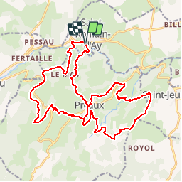
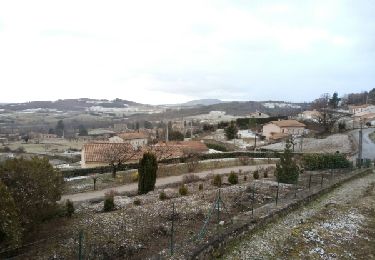
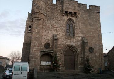
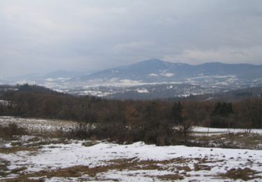
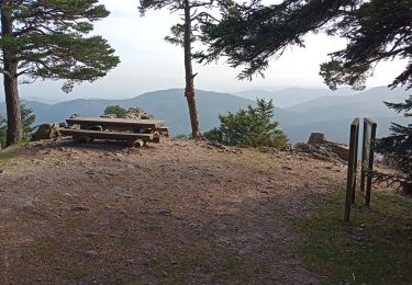
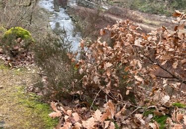
Randonnée Marche de 23 km à découvrir à Auvergne-Rhône-Alpes, Ardèche, Saint-Romain-d'Ay. Cette randonnée est proposée par tracegps.
Description
La Coq'in randonnée est organisée par le village de St Romain d'Ay. L'ensemble du parcours se déroule sur des sentiers et chemins. Le circuit peut-être réduit à une petite boucle de 12,5 km.
Localisation
Pays :
France
Région :
Auvergne-Rhône-Alpes
Département/Province :
Ardèche
Commune :
Saint-Romain-d'Ay
Localité :
Unknown
Départ:(Dec)
Départ:(UTM)
630636 ; 5002476 (31T) N.
Commentaires
Randonnées à proximité
![Randonnée Course à pied Quintenas - roche Péréandre, pont suspendu circuit - Photo](https://media.geolcdn.com/t/375/260/1ca2ef30-37ec-41a5-8885-fe3e88c20bbf.jpg&format=jpg&maxdim=2)
![Course à pied Course à pied](https://static1.geolcdn.com/sitytour/trail-icons/103.png)
roche Péréandre, pont suspendu circuit
Course à pied
Moyen
Quintenas,
Auvergne-Rhône-Alpes,
Ardèche,
France
![](/images/other/stat-length.png)
11,6 km | 16,1 km-effort
1h 35min
![](https://static1.geolcdn.com/siteimages/upload/files/16400158638029165_repeat_loop_refresh_sync_direction_icon.png)
Oui
![Randonnée Marche Saint-Romain-d'Ay - Saint-Romain-d'Ay petite boucle - Photo](https://media.geolcdn.com/t/375/260/e8ea32c7-0f91-4af6-b35c-a29b3198ac16.jpg&format=jpg&maxdim=2)
![Marche Marche](https://static1.geolcdn.com/sitytour/trail-icons/101.png)
Saint-Romain-d'Ay petite boucle
Marche
Facile
Saint-Romain-d'Ay,
Auvergne-Rhône-Alpes,
Ardèche,
France
![](/images/other/stat-length.png)
8,9 km | 12,4 km-effort
2h 29min
![](https://static1.geolcdn.com/siteimages/upload/files/16400158638029165_repeat_loop_refresh_sync_direction_icon.png)
Oui
![Randonnée Marche Saint-Alban-d'Ay - GRP Tour du bassin d'Annonay - Photo](https://media.geolcdn.com/t/375/260/ext.jpg?maxdim=2&url=https%3A%2F%2Fservices.sitytrail.com%2FGeolivesWS%2FDownloadMedia.ashx%3FTrailID%3D684228%26Media%3Dfix__20170113160856.jpg)
![Marche Marche](https://static1.geolcdn.com/sitytour/trail-icons/101.png)
GRP Tour du bassin d'Annonay
Marche
Moyen
Saint-Alban-d'Ay,
Auvergne-Rhône-Alpes,
Ardèche,
France
![](/images/other/stat-length.png)
102 km | 145 km-effort
23h 36min
![](https://static1.geolcdn.com/siteimages/upload/files/16400158638029165_repeat_loop_refresh_sync_direction_icon.png)
Oui
![Randonnée Marche Quintenas - tour d'Annonay - Photo](https://media.geolcdn.com/t/375/260/ext.jpg?maxdim=2&url=https%3A%2F%2Fservices.sitytrail.com%2FGeolivesWS%2FDownloadMedia.ashx%3FTrailID%3D677923%26Media%3Dfix__20161229170755.jpg)
![Marche Marche](https://static1.geolcdn.com/sitytour/trail-icons/101.png)
tour d'Annonay
Marche
Facile
Quintenas,
Auvergne-Rhône-Alpes,
Ardèche,
France
![](/images/other/stat-length.png)
30 km | 38 km-effort
8h 10min
![](https://static1.geolcdn.com/siteimages/upload/files/16400158638029165_repeat_loop_refresh_sync_direction_icon.png)
Oui
![Randonnée Marche Saint-Alban-d'Ay - Suc de Vent - St Alban D''Ay - Photo](https://media.geolcdn.com/t/375/260/ext.jpg?maxdim=2&url=https%3A%2F%2Fservices.sitytrail.com%2FGeolivesWS%2FDownloadMedia.ashx%3FTrailID%3D215282%26Media%3D15644_1.jpg)
![Marche Marche](https://static1.geolcdn.com/sitytour/trail-icons/101.png)
Suc de Vent - St Alban D''Ay
Marche
Moyen
Saint-Alban-d'Ay,
Auvergne-Rhône-Alpes,
Ardèche,
France
![](/images/other/stat-length.png)
24 km | 36 km-effort
8h 0min
![](https://static1.geolcdn.com/siteimages/upload/files/16400158638029165_repeat_loop_refresh_sync_direction_icon.png)
Oui
![Randonnée Marche Satillieu - satilleux Vérines mont Chaix le traiteur la garenne - Photo](https://media.geolcdn.com/t/375/260/c03d5efd-2f93-4139-b293-ab049c74155a.jpg&format=jpg&maxdim=2)
![Marche Marche](https://static1.geolcdn.com/sitytour/trail-icons/101.png)
satilleux Vérines mont Chaix le traiteur la garenne
Marche
Très difficile
Satillieu,
Auvergne-Rhône-Alpes,
Ardèche,
France
![](/images/other/stat-length.png)
22 km | 34 km-effort
5h 31min
![](https://static1.geolcdn.com/siteimages/upload/files/16400158638029165_repeat_loop_refresh_sync_direction_icon.png)
Oui
![Randonnée Marche Saint-Jeure-d'Ay - St Jeure d'Ay Royol Navas camping St Victor Chantelermuze les Chanaux Riollier Les Bruyeres Préaux Renaudin les Cros la Croix des Plantas Barrideau Zipon, retour St Jeure - Photo](https://media.geolcdn.com/t/375/260/ext.jpg?maxdim=2&url=https%3A%2F%2Fstatic1.geolcdn.com%2Fsiteimages%2Fupload%2Ffiles%2F1553511878bg_sport_marche.png)
![Marche Marche](https://static1.geolcdn.com/sitytour/trail-icons/101.png)
St Jeure d'Ay Royol Navas camping St Victor Chantelermuze les Chanaux Riolli...
Marche
Très difficile
Saint-Jeure-d'Ay,
Auvergne-Rhône-Alpes,
Ardèche,
France
![](/images/other/stat-length.png)
22 km | 31 km-effort
7h 1min
![](https://static1.geolcdn.com/siteimages/upload/files/16400158638029165_repeat_loop_refresh_sync_direction_icon.png)
Oui
![Randonnée Randonnée équestre Quintenas - Ardèche – Sources de la Cance en 3 jours - Photo](https://media.geolcdn.com/t/375/260/ext.jpg?maxdim=2&url=https%3A%2F%2Fstatic1.geolcdn.com%2Fsiteimages%2Fupload%2Ffiles%2F1524743154cheval.jpg)
![Randonnée équestre Randonnée équestre](https://static1.geolcdn.com/sitytour/trail-icons/301.png)
Ardèche – Sources de la Cance en 3 jours
Randonnée équestre
Facile
Quintenas,
Auvergne-Rhône-Alpes,
Ardèche,
France
![](/images/other/stat-length.png)
71 km | 103 km-effort
13h 32min
![](https://static1.geolcdn.com/siteimages/upload/files/16400158638029165_repeat_loop_refresh_sync_direction_icon.png)
Oui
![Randonnée Marche Quintenas - Quintenas rando - Photo](https://media.geolcdn.com/t/375/260/ad0847dd-9c53-4138-af74-a67188bfca7f.jpg&format=jpg&maxdim=2)
![Marche Marche](https://static1.geolcdn.com/sitytour/trail-icons/101.png)
Quintenas rando
Marche
Quintenas,
Auvergne-Rhône-Alpes,
Ardèche,
France
![](/images/other/stat-length.png)
16,6 km | 22 km-effort
6h 20min
![](https://static1.geolcdn.com/siteimages/upload/files/16400158638029165_repeat_loop_refresh_sync_direction_icon.png)
Oui