![](/images/other/stat-length.png)
![Randonnée Marche Saint-Jean-Trolimon - La marche des trois chapelles - Photo](https://media.geolcdn.com/t/1900/400/ext.pjpeg?maxdim=2&url=https%3A%2F%2Fstatic1.geolcdn.com%2Fsiteimages%2Fupload%2Ffiles%2F1553511878bg_sport_marche.png)
La marche des trois chapelles
wallander76
Utilisateur
![Longueur](/images/other/stat-length.png)
Longueur
14,5 km
![Altitude max](https://static1.geolcdn.com/siteimages/upload/files/1508320355ic_sort_altitude_max_24dp.png)
Altitude max
33 m
![Dénivelé positif](https://static1.geolcdn.com/siteimages/upload/files/1508320355ic_sort_den_pos_24dp.png)
Dénivelé positif
99 m
![Km-Effort](/images/other/stat-length.png)
Km-Effort
15,8 km
![Altitude min](https://static1.geolcdn.com/siteimages/upload/files/1508320355ic_sort_altitude_min_24dp.png)
Altitude min
2 m
![Dénivelé négatif](https://static1.geolcdn.com/siteimages/upload/files/1508320355ic_sort_den_neg_24dp.png)
Dénivelé négatif
95 m
![Boucle](https://static1.geolcdn.com/siteimages/upload/files/16400158638029165_repeat_loop_refresh_sync_direction_icon.png)
Boucle
Oui
Date de création :
2014-12-10 00:00:00.0
Dernière modification :
2014-12-10 00:00:00.0
![Marche](https://static1.geolcdn.com/sitytour/trail-icons/101.png)
3h31
Difficulté : Moyen
![Scannez ce code QR pour ouvrir la randonnée dans l'application SityTrail](https://capi.geolives.com/qq0zvz2zws4bq2lad0pu/sitytour/trails/190828/qr.png?size=200)
Application GPS de randonnée GRATUITE
À propos
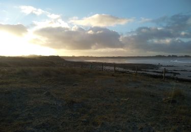
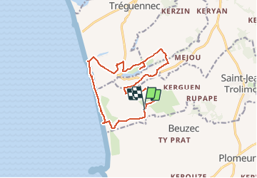
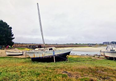
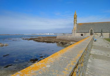
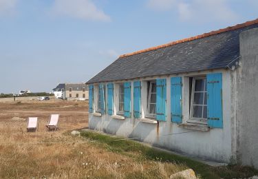
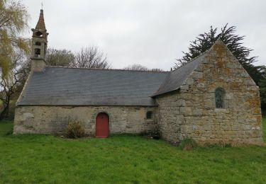
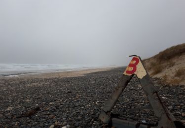
Randonnée Marche de 14,5 km à découvrir à Bretagne, Finistère, Saint-Jean-Trolimon. Cette randonnée est proposée par wallander76.
Description
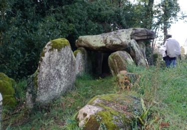
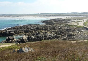
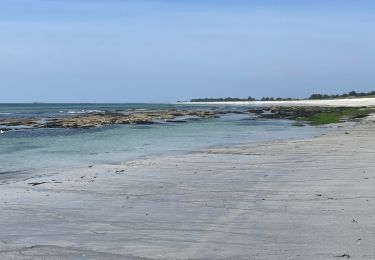
Superbe marche entre terre et mer en passant par les Chapelles de Tronoan, Saint-Vio et Saint-Evy. Un vrai petit pélerinage...
Localisation
Pays :
France
Région :
Bretagne
Département/Province :
Finistère
Commune :
Saint-Jean-Trolimon
Localité :
Unknown
Départ:(Dec)
Départ:(UTM)
400625 ; 5301232 (30T) N.
Commentaires
Randonnées à proximité
![Randonnée A pied Penmarc'h - TREK RCY GR34 2022 J6 Pen Marc'h - Loctudy - Photo](https://media.geolcdn.com/t/375/260/e0596856-50ca-44a8-8aac-fad11cae8684.jpg&format=jpg&maxdim=2)
![A pied A pied](https://static1.geolcdn.com/sitytour/trail-icons/100.png)
TREK RCY GR34 2022 J6 Pen Marc'h - Loctudy
A pied
Moyen
Penmarc'h,
Bretagne,
Finistère,
France
![](/images/other/stat-length.png)
30 km | 32 km-effort
7h 14min
![](https://static1.geolcdn.com/siteimages/upload/files/16400158638029165_repeat_loop_refresh_sync_direction_icon.png)
Non
![Randonnée Marche Plomeur - Pointe de la Torche - Pointe de Penmarc'h Kérity boucle GR34 - 18.2km 85m 5h00 (35mn) - 2019 09 11 - Photo](https://media.geolcdn.com/t/375/260/65aca7ce-b2b8-4204-a697-01fa894526e1.jpg&format=jpg&maxdim=2)
![Marche Marche](https://static1.geolcdn.com/sitytour/trail-icons/101.png)
Pointe de la Torche - Pointe de Penmarc'h Kérity boucle GR34 - 18.2km 85m 5h0...
Marche
Facile
Plomeur,
Bretagne,
Finistère,
France
![](/images/other/stat-length.png)
18,2 km | 19,3 km-effort
5h 0min
![](https://static1.geolcdn.com/siteimages/upload/files/16400158638029165_repeat_loop_refresh_sync_direction_icon.png)
Oui
![Randonnée A pied Plomeur - PLOMEUR - Photo](https://media.geolcdn.com/t/375/260/61520ad5-9a28-4010-847f-793b1c68649a.jpg&format=jpg&maxdim=2)
![A pied A pied](https://static1.geolcdn.com/sitytour/trail-icons/100.png)
![Randonnée Marche Penmarc'h - pointe de Penmarc'h - Photo](https://media.geolcdn.com/t/375/260/6f509581-3bad-433a-8135-edbf50fcef53.jpg&format=jpg&maxdim=2)
![Marche Marche](https://static1.geolcdn.com/sitytour/trail-icons/101.png)
pointe de Penmarc'h
Marche
Très facile
Penmarc'h,
Bretagne,
Finistère,
France
![](/images/other/stat-length.png)
13 km | 13,9 km-effort
3h 38min
![](https://static1.geolcdn.com/siteimages/upload/files/16400158638029165_repeat_loop_refresh_sync_direction_icon.png)
Oui
![Randonnée Marche Plomeur - Pointe de Penmarch - Photo](https://media.geolcdn.com/t/375/260/ext.jpg?maxdim=2&url=https%3A%2F%2Fservices.sitytrail.com%2FGeolivesWS%2FDownloadMedia.ashx%3FTrailID%3D460872%26Media%3Dfix__20150818112133.jpg)
![Marche Marche](https://static1.geolcdn.com/sitytour/trail-icons/101.png)
Pointe de Penmarch
Marche
Facile
(2)
Plomeur,
Bretagne,
Finistère,
France
![](/images/other/stat-length.png)
17,4 km | 18,6 km-effort
4h 8min
![](https://static1.geolcdn.com/siteimages/upload/files/16400158638029165_repeat_loop_refresh_sync_direction_icon.png)
Oui
![Randonnée Marche Penmarc'h - Saint Guenole - Le Guivinec - Photo](https://media.geolcdn.com/t/375/260/dc87e6a2-66e8-49d0-b1a1-cebb48345538.jpg&format=jpg&maxdim=2)
![Marche Marche](https://static1.geolcdn.com/sitytour/trail-icons/101.png)
Saint Guenole - Le Guivinec
Marche
Moyen
Penmarc'h,
Bretagne,
Finistère,
France
![](/images/other/stat-length.png)
11,3 km | 11,9 km-effort
2h 53min
![](https://static1.geolcdn.com/siteimages/upload/files/16400158638029165_repeat_loop_refresh_sync_direction_icon.png)
Non
![Randonnée Marche Saint-Jean-Trolimon - st evy - Photo](https://media.geolcdn.com/t/375/260/ea9dec44-1ddd-47ee-89e3-481086e7a6b9.jpg&format=jpg&maxdim=2)
![Marche Marche](https://static1.geolcdn.com/sitytour/trail-icons/101.png)
st evy
Marche
Très facile
Saint-Jean-Trolimon,
Bretagne,
Finistère,
France
![](/images/other/stat-length.png)
13,4 km | 14,7 km-effort
2h 23min
![](https://static1.geolcdn.com/siteimages/upload/files/16400158638029165_repeat_loop_refresh_sync_direction_icon.png)
Oui
![Randonnée Marche Saint-Jean-Trolimon - 020220 - Photo](https://media.geolcdn.com/t/375/260/652ec4dc-4d7b-45d2-8160-9ca123114255.jpg&format=jpg&maxdim=2)
![Marche Marche](https://static1.geolcdn.com/sitytour/trail-icons/101.png)
020220
Marche
Très facile
Saint-Jean-Trolimon,
Bretagne,
Finistère,
France
![](/images/other/stat-length.png)
11,8 km | 12,9 km-effort
2h 13min
![](https://static1.geolcdn.com/siteimages/upload/files/16400158638029165_repeat_loop_refresh_sync_direction_icon.png)
Oui
![Randonnée Marche Plomeur - PENMARC'H - Photo](https://media.geolcdn.com/t/375/260/ee26b08c-72e2-413b-a6b3-70f24db53901.jpg&format=jpg&maxdim=2)
![Marche Marche](https://static1.geolcdn.com/sitytour/trail-icons/101.png)