Randonnée Moteur Lieusaint - quad rando - Photo
 saw1983
saw1983

Utilisateur

© OpenStreetMap contributors
Longueur
Longueur
27 km
Altitude max
Altitude max
40 m
Dénivelé positif
Dénivelé positif
188 m
Km-Effort
Km-Effort  
29 km
Altitude min
Altitude min
5 m
Dénivelé négatif
Dénivelé négatif
190 m
Boucle
Boucle
Oui
Date de création :
2014-12-10 00:00:00.0
Dernière modification :
2014-12-10 00:00:00.0

(0 Avis)

Moteur
Moteur
1h00
Difficulté : Moyen

Scannez ce code QR pour ouvrir la randonnée dans l'application SityTrail

Application GPS de randonnée GRATUITE

Logo SityTrail SityTrail

IGN / Instituts géographiques

Télécharger SityTrail sur l'App Store Télécharger SityTrail sur Google Play

Logo SityTrail SityTrail World

Le monde est à vous

Télécharger SityTrail sur l'App Store Télécharger SityTrail sur Google Play Télécharger SityTrail sur Huawei AppGallery

À propos

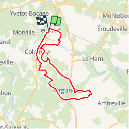
Randonnée Moteur de 27 km à découvrir à Normandie, Manche, Lieusaint. Cette randonnée est proposée par saw1983.

Description

ptit test rando en quad

Profil altimétrique

Localisation

Pays :
France
Région :
Normandie
Département/Province :
Manche
Commune :
Lieusaint
Localité :
Unknown
Départ:(Dec)
Départ:(UTM)
610325 ; 5481229 (30U) N.

Randonnées à proximité

Randonnée V.T.T. Valognes - La JC M 2010 - Valognes - Photo
V.T.T.
tracegps

V.T.T.

Difficile
(1)
Valognes, Normandie, Manche, France
49 km | 59 km-effort
3h 0min
Oui
Randonnée Marche Hémevez - Hémevez - Photo
Marche
PatRando

Marche

Moyen
Hémevez, Normandie, Manche, France
12,4 km | 13,7 km-effort
2h 31min
Oui
Randonnée Marche Valognes - Valognes - Photo
Marche
PatRando

Marche

Moyen
Valognes, Normandie, Manche, France
11,8 km | 13,6 km-effort
2h 12min
Oui
Randonnée V.T.T. Valognes - La JCM 2013 - randonnée en pays valognais - Photo
V.T.T.
tracegps

V.T.T.

Difficile
Valognes, Normandie, Manche, France
54 km | 66 km-effort
3h 30min
Oui
Randonnée V.T.T. Valognes - Rando d''Alauna 2013  -  50 km - Valognes - Photo
V.T.T.
tracegps

V.T.T.

Difficile
Valognes, Normandie, Manche, France
47 km | 56 km-effort
2h 30min
Non
Randonnée Marche Urville - ueville - Photo
Marche
xcreator

Marche

Moyen
Urville, Normandie, Manche, France
9,2 km | 10,3 km-effort
1h 59min
Non
Randonnée V.T.T. Yvetot-Bocage - Rando de Yvetot-Bocage 2013 - Photo
V.T.T.
tracegps

V.T.T.

Moyen
Yvetot-Bocage, Normandie, Manche, France
42 km | 47 km-effort
2h 45min
Oui
Randonnée V.T.T. Sortosville - La Sortosvillaise 2013 - Sortosville - Photo
V.T.T.
tracegps

V.T.T.

Moyen
Sortosville, Normandie, Manche, France
27 km | 30 km-effort
2h 0min
Oui
Randonnée Marche Colomby - Le Cul de fer - Colomby - Photo
Marche
tracegps

Marche

Moyen
(2)
Colomby, Normandie, Manche, France
11 km | 12,2 km-effort
3h 30min
Oui


Fermer
Mes abonnements