![](/images/other/stat-length.png)
![Randonnée Vélo Flines-lez-Raches - Flines - Canal de la Scarpe 2 - Photo](https://media.geolcdn.com/t/1900/400/ext.pjpeg?maxdim=2&url=https%3A%2F%2Fstatic1.geolcdn.com%2Fsiteimages%2Fupload%2Ffiles%2F1524743154velo.jpg)
Flines - Canal de la Scarpe 2
yandes
Utilisateur
![Longueur](/images/other/stat-length.png)
Longueur
16,2 km
![Altitude max](https://static1.geolcdn.com/siteimages/upload/files/1508320355ic_sort_altitude_max_24dp.png)
Altitude max
34 m
![Dénivelé positif](https://static1.geolcdn.com/siteimages/upload/files/1508320355ic_sort_den_pos_24dp.png)
Dénivelé positif
73 m
![Km-Effort](/images/other/stat-length.png)
Km-Effort
17,2 km
![Altitude min](https://static1.geolcdn.com/siteimages/upload/files/1508320355ic_sort_altitude_min_24dp.png)
Altitude min
13 m
![Dénivelé négatif](https://static1.geolcdn.com/siteimages/upload/files/1508320355ic_sort_den_neg_24dp.png)
Dénivelé négatif
74 m
![Boucle](https://static1.geolcdn.com/siteimages/upload/files/16400158638029165_repeat_loop_refresh_sync_direction_icon.png)
Boucle
Oui
Date de création :
2014-12-10 00:00:00.0
Dernière modification :
2014-12-10 00:00:00.0
![Vélo](https://static1.geolcdn.com/sitytour/trail-icons/200.png)
1h01
Difficulté : Facile
![Scannez ce code QR pour ouvrir la randonnée dans l'application SityTrail](https://capi.geolives.com/qq0zvz2zws4bq2lad0pu/sitytour/trails/190411/qr.png?size=200)
Application GPS de randonnée GRATUITE
À propos
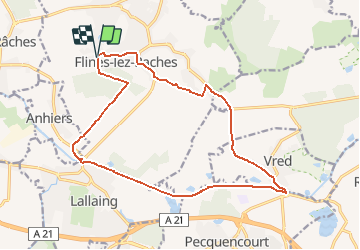
Randonnée Vélo de 16,2 km à découvrir à Hauts-de-France, Nord, Flines-lez-Raches. Cette randonnée est proposée par yandes.
Description
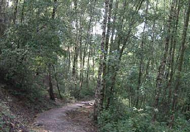
Tout chemin sans difficulté, à éviter en période humide. Un petit secteur pavé (< 500 m), carrossable néanmoins, et quelques chemins de terre.
Localisation
Pays :
France
Région :
Hauts-de-France
Département/Province :
Nord
Commune :
Flines-lez-Raches
Localité :
Unknown
Départ:(Dec)
Départ:(UTM)
512131 ; 5585125 (31U) N.
Commentaires
Randonnées à proximité
![Randonnée Marche Coutiches - Circuit des chapelles de Coutiches. - Photo](https://media.geolcdn.com/t/375/260/ext.jpg?maxdim=2&url=https%3A%2F%2Fservices.sitytrail.com%2FGeolivesWS%2FDownloadMedia.ashx%3FTrailID%3D106517%26Media%3D11069_6.jpg)
![Marche Marche](https://static1.geolcdn.com/sitytour/trail-icons/101.png)
Circuit des chapelles de Coutiches.
Marche
Difficile
(1)
Coutiches,
Hauts-de-France,
Nord,
France
![](/images/other/stat-length.png)
15,2 km | 16,3 km-effort
3h 34min
![](https://static1.geolcdn.com/siteimages/upload/files/16400158638029165_repeat_loop_refresh_sync_direction_icon.png)
Oui
![Randonnée V.T.T. Lallaing - lallaing - la fosse delloye - Photo](https://media.geolcdn.com/t/375/260/ext.jpg?maxdim=2&url=https%3A%2F%2Fservices.sitytrail.com%2FGeolivesWS%2FDownloadMedia.ashx%3FTrailID%3D148722%26Media%3D20120821181041.jpg)
![V.T.T. V.T.T.](https://static1.geolcdn.com/sitytour/trail-icons/202.png)
lallaing - la fosse delloye
V.T.T.
Moyen
(1)
Lallaing,
Hauts-de-France,
Nord,
France
![](/images/other/stat-length.png)
26 km | 29 km-effort
1h 41min
![](https://static1.geolcdn.com/siteimages/upload/files/16400158638029165_repeat_loop_refresh_sync_direction_icon.png)
Non
![Randonnée V.T.T. Lallaing - 2012-08-17 lallaing 3 cavaliers - Photo](https://media.geolcdn.com/t/375/260/ext.jpg?maxdim=2&url=https%3A%2F%2Fservices.sitytrail.com%2FGeolivesWS%2FDownloadMedia.ashx%3FTrailID%3D147793%26Media%3D20120817182019.jpg)
![V.T.T. V.T.T.](https://static1.geolcdn.com/sitytour/trail-icons/202.png)
2012-08-17 lallaing 3 cavaliers
V.T.T.
Moyen
(1)
Lallaing,
Hauts-de-France,
Nord,
France
![](/images/other/stat-length.png)
44 km | 47 km-effort
2h 50min
![](https://static1.geolcdn.com/siteimages/upload/files/16400158638029165_repeat_loop_refresh_sync_direction_icon.png)
Non
![Randonnée Marche Roost-Warendin - Roost Warendint : Escarpelle et Paturelle - Photo](https://media.geolcdn.com/t/375/260/ext.jpg?maxdim=2&url=https%3A%2F%2Fstatic1.geolcdn.com%2Fsiteimages%2Fupload%2Ffiles%2F1553511878bg_sport_marche.png)
![Marche Marche](https://static1.geolcdn.com/sitytour/trail-icons/101.png)
Roost Warendint : Escarpelle et Paturelle
Marche
Moyen
(1)
Roost-Warendin,
Hauts-de-France,
Nord,
France
![](/images/other/stat-length.png)
10,9 km | 12,7 km-effort
2h 47min
![](https://static1.geolcdn.com/siteimages/upload/files/16400158638029165_repeat_loop_refresh_sync_direction_icon.png)
Oui
![Randonnée V.T.T. Lallaing - lallaing - circuit de l'elpret - Photo](https://media.geolcdn.com/t/375/260/ext.jpg?maxdim=2&url=https%3A%2F%2Fstatic1.geolcdn.com%2Fsiteimages%2Fupload%2Ffiles%2F1524743154velo.jpg)
![V.T.T. V.T.T.](https://static1.geolcdn.com/sitytour/trail-icons/202.png)
lallaing - circuit de l'elpret
V.T.T.
Moyen
(1)
Lallaing,
Hauts-de-France,
Nord,
France
![](/images/other/stat-length.png)
40 km | 43 km-effort
2h 56min
![](https://static1.geolcdn.com/siteimages/upload/files/16400158638029165_repeat_loop_refresh_sync_direction_icon.png)
Oui
![Randonnée V.T.T. Anhiers - lallaing - Mons en peveles - Photo](https://media.geolcdn.com/t/375/260/ext.jpg?maxdim=2&url=https%3A%2F%2Fstatic1.geolcdn.com%2Fsiteimages%2Fupload%2Ffiles%2F1524743154velo.jpg)
![V.T.T. V.T.T.](https://static1.geolcdn.com/sitytour/trail-icons/202.png)
lallaing - Mons en peveles
V.T.T.
Facile
(1)
Anhiers,
Hauts-de-France,
Nord,
France
![](/images/other/stat-length.png)
27 km | 29 km-effort
1h 32min
![](https://static1.geolcdn.com/siteimages/upload/files/16400158638029165_repeat_loop_refresh_sync_direction_icon.png)
Non
![Randonnée V.T.T. Anhiers - rando renard - Photo](https://media.geolcdn.com/t/375/260/ext.jpg?maxdim=2&url=https%3A%2F%2Fstatic1.geolcdn.com%2Fsiteimages%2Fupload%2Ffiles%2F1524743154velo.jpg)
![V.T.T. V.T.T.](https://static1.geolcdn.com/sitytour/trail-icons/202.png)
rando renard
V.T.T.
Très facile
(1)
Anhiers,
Hauts-de-France,
Nord,
France
![](/images/other/stat-length.png)
20 km | 22 km-effort
1h 17min
![](https://static1.geolcdn.com/siteimages/upload/files/16400158638029165_repeat_loop_refresh_sync_direction_icon.png)
Non
![Randonnée V.T.T. Flines-lez-Raches - La rando VTT des Renards des Sables - Flines les Raches - Photo](https://media.geolcdn.com/t/375/260/ext.jpg?maxdim=2&url=https%3A%2F%2Fservices.sitytrail.com%2FGeolivesWS%2FDownloadMedia.ashx%3FTrailID%3D118694%26Media%3D12864_3.jpg)
![V.T.T. V.T.T.](https://static1.geolcdn.com/sitytour/trail-icons/202.png)
La rando VTT des Renards des Sables - Flines les Raches
V.T.T.
Difficile
Flines-lez-Raches,
Hauts-de-France,
Nord,
France
![](/images/other/stat-length.png)
47 km | 52 km-effort
3h 0min
![](https://static1.geolcdn.com/siteimages/upload/files/16400158638029165_repeat_loop_refresh_sync_direction_icon.png)
Non
![Randonnée Marche Vred - Circuit de Germignies - Vred - Photo](https://media.geolcdn.com/t/375/260/ext.jpg?maxdim=2&url=https%3A%2F%2Fservices.sitytrail.com%2FGeolivesWS%2FDownloadMedia.ashx%3FTrailID%3D111942%26Media%3D9083_6.jpg)
![Marche Marche](https://static1.geolcdn.com/sitytour/trail-icons/101.png)
Circuit de Germignies - Vred
Marche
Moyen
(1)
Vred,
Hauts-de-France,
Nord,
France
![](/images/other/stat-length.png)
7,6 km | 8,2 km-effort
2h 0min
![](https://static1.geolcdn.com/siteimages/upload/files/16400158638029165_repeat_loop_refresh_sync_direction_icon.png)
Oui