![](/images/other/stat-length.png)
![Randonnée Cheval Saint-Pierre-d'Oléron - Le Paddock - La mer - Photo](https://media.geolcdn.com/t/1900/400/ext.pjpeg?maxdim=2&url=https%3A%2F%2Fstatic1.geolcdn.com%2Fsiteimages%2Fupload%2Ffiles%2F1524743154cheval.jpg)
Le Paddock - La mer
socrate86
Utilisateur
![Longueur](/images/other/stat-length.png)
Longueur
16,4 km
![Altitude max](https://static1.geolcdn.com/siteimages/upload/files/1508320355ic_sort_altitude_max_24dp.png)
Altitude max
18 m
![Dénivelé positif](https://static1.geolcdn.com/siteimages/upload/files/1508320355ic_sort_den_pos_24dp.png)
Dénivelé positif
76 m
![Km-Effort](/images/other/stat-length.png)
Km-Effort
17,5 km
![Altitude min](https://static1.geolcdn.com/siteimages/upload/files/1508320355ic_sort_altitude_min_24dp.png)
Altitude min
-1 m
![Dénivelé négatif](https://static1.geolcdn.com/siteimages/upload/files/1508320355ic_sort_den_neg_24dp.png)
Dénivelé négatif
77 m
![Boucle](https://static1.geolcdn.com/siteimages/upload/files/16400158638029165_repeat_loop_refresh_sync_direction_icon.png)
Boucle
Non
Date de création :
2014-12-10 00:00:00.0
Dernière modification :
2014-12-10 00:00:00.0
![Cheval](https://static1.geolcdn.com/sitytour/trail-icons/300.png)
2h14
Difficulté : Moyen
![Scannez ce code QR pour ouvrir la randonnée dans l'application SityTrail](https://capi.geolives.com/qq0zvz2zws4bq2lad0pu/sitytour/trails/189766/qr.png?size=200)
Application GPS de randonnée GRATUITE
À propos
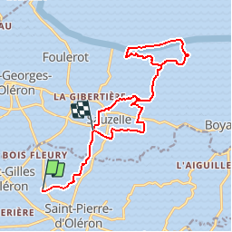
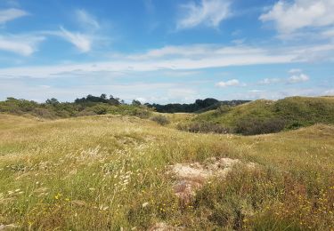
Randonnée Cheval de 16,4 km à découvrir à Nouvelle-Aquitaine, Charente-Maritime, Saint-Pierre-d'Oléron. Cette randonnée est proposée par socrate86.
Description
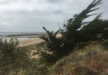
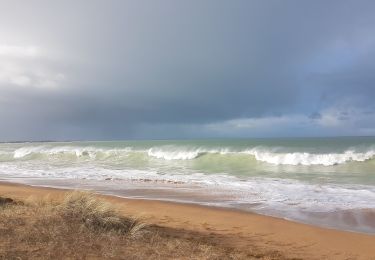
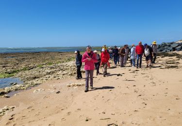
Petit parcours de moins de 20 km pour aller jusqu'à la mer, au niveau de la plage des Saumonards.
Possibilités d'attacher les chevaux à "La Nouette"
Localisation
Pays :
France
Région :
Nouvelle-Aquitaine
Département/Province :
Charente-Maritime
Commune :
Saint-Pierre-d'Oléron
Localité :
Unknown
Départ:(Dec)
Départ:(UTM)
630248 ; 5089952 (30T) N.
Commentaires
Randonnées à proximité
![Randonnée Marche Saint-Pierre-d'Oléron - oléron salines - Photo](https://media.geolcdn.com/t/375/260/ext.jpg?maxdim=2&url=https%3A%2F%2Fstatic1.geolcdn.com%2Fsiteimages%2Fupload%2Ffiles%2F1553511878bg_sport_marche.png)
![Marche Marche](https://static1.geolcdn.com/sitytour/trail-icons/101.png)
oléron salines
Marche
Très facile
(3)
Saint-Pierre-d'Oléron,
Nouvelle-Aquitaine,
Charente-Maritime,
France
![](/images/other/stat-length.png)
9,2 km | 9,6 km-effort
2h 2min
![](https://static1.geolcdn.com/siteimages/upload/files/16400158638029165_repeat_loop_refresh_sync_direction_icon.png)
Oui
![Randonnée Marche Saint-Pierre-d'Oléron - Balade japonaise La Mimiche - Photo](https://media.geolcdn.com/t/375/260/aba403ea-f168-4b1a-98e2-396bc0622e38.jpg&format=jpg&maxdim=2)
![Marche Marche](https://static1.geolcdn.com/sitytour/trail-icons/101.png)
Balade japonaise La Mimiche
Marche
Moyen
Saint-Pierre-d'Oléron,
Nouvelle-Aquitaine,
Charente-Maritime,
France
![](/images/other/stat-length.png)
8,7 km | 9,5 km-effort
2h 24min
![](https://static1.geolcdn.com/siteimages/upload/files/16400158638029165_repeat_loop_refresh_sync_direction_icon.png)
Oui
![Randonnée Marche Saint-Pierre-d'Oléron - rando st pierre - Photo](https://media.geolcdn.com/t/375/260/7d3fce1d-b4ee-48a8-b9a7-16a5114dfe82.jpg&format=jpg&maxdim=2)
![Marche Marche](https://static1.geolcdn.com/sitytour/trail-icons/101.png)
rando st pierre
Marche
Très facile
Saint-Pierre-d'Oléron,
Nouvelle-Aquitaine,
Charente-Maritime,
France
![](/images/other/stat-length.png)
12,4 km | 12,9 km-effort
4h 5min
![](https://static1.geolcdn.com/siteimages/upload/files/16400158638029165_repeat_loop_refresh_sync_direction_icon.png)
Oui
![Randonnée V.T.T. Saint-Georges-d'Oléron - 12092013 - Photo](https://media.geolcdn.com/t/375/260/ext.jpg?maxdim=2&url=https%3A%2F%2Fservices.sitytrail.com%2FGeolivesWS%2FDownloadMedia.ashx%3FTrailID%3D220725%26Media%3Dfix__20130912110800.jpg)
![V.T.T. V.T.T.](https://static1.geolcdn.com/sitytour/trail-icons/202.png)
12092013
V.T.T.
Facile
Saint-Georges-d'Oléron,
Nouvelle-Aquitaine,
Charente-Maritime,
France
![](/images/other/stat-length.png)
90 km | 95 km-effort
4h 30min
![](https://static1.geolcdn.com/siteimages/upload/files/16400158638029165_repeat_loop_refresh_sync_direction_icon.png)
Oui
![Randonnée Marche Saint-Georges-d'Oléron - domino - Photo](https://media.geolcdn.com/t/375/260/e5423c97-cceb-4912-8f52-9c9f999bbd44.jpg&format=jpg&maxdim=2)
![Marche Marche](https://static1.geolcdn.com/sitytour/trail-icons/101.png)
domino
Marche
Facile
Saint-Georges-d'Oléron,
Nouvelle-Aquitaine,
Charente-Maritime,
France
![](/images/other/stat-length.png)
7,4 km | 8,3 km-effort
2h 31min
![](https://static1.geolcdn.com/siteimages/upload/files/16400158638029165_repeat_loop_refresh_sync_direction_icon.png)
Oui
![Randonnée Marche Saint-Georges-d'Oléron - gautrelle - Photo](https://media.geolcdn.com/t/375/260/07583435-cb47-46e6-8e8c-81f97e05f394.jpg&format=jpg&maxdim=2)
![Marche Marche](https://static1.geolcdn.com/sitytour/trail-icons/101.png)
gautrelle
Marche
Moyen
Saint-Georges-d'Oléron,
Nouvelle-Aquitaine,
Charente-Maritime,
France
![](/images/other/stat-length.png)
7,2 km | 8 km-effort
1h 58min
![](https://static1.geolcdn.com/siteimages/upload/files/16400158638029165_repeat_loop_refresh_sync_direction_icon.png)
Oui
![Randonnée Vélo électrique Dolus-d'Oléron - explorer - Photo](https://media.geolcdn.com/t/375/260/4c089d45-439c-46af-9719-c41ff54dbc9a.jpg&format=jpg&maxdim=2)
![Vélo électrique Vélo électrique](https://static1.geolcdn.com/sitytour/trail-icons/205.png)
explorer
Vélo électrique
Facile
Dolus-d'Oléron,
Nouvelle-Aquitaine,
Charente-Maritime,
France
![](/images/other/stat-length.png)
20 km | 22 km-effort
1h 32min
![](https://static1.geolcdn.com/siteimages/upload/files/16400158638029165_repeat_loop_refresh_sync_direction_icon.png)
Oui
![Randonnée Marche Saint-Pierre-d'Oléron - St Pierre 1205 - Photo](https://media.geolcdn.com/t/375/260/fa452f64-8edb-4147-a850-780b399cf2e8.jpg&format=jpg&maxdim=2)
![Marche Marche](https://static1.geolcdn.com/sitytour/trail-icons/101.png)
St Pierre 1205
Marche
Moyen
Saint-Pierre-d'Oléron,
Nouvelle-Aquitaine,
Charente-Maritime,
France
![](/images/other/stat-length.png)
6 km | 6,4 km-effort
3h 22min
![](https://static1.geolcdn.com/siteimages/upload/files/16400158638029165_repeat_loop_refresh_sync_direction_icon.png)
Oui
![Randonnée Marche Saint-Georges-d'Oléron - sables viguier - Photo](https://media.geolcdn.com/t/375/260/93ed052a-50b4-4459-95ce-f424f03253af.jpg&format=jpg&maxdim=2)
![Marche Marche](https://static1.geolcdn.com/sitytour/trail-icons/101.png)
sables viguier
Marche
Très facile
Saint-Georges-d'Oléron,
Nouvelle-Aquitaine,
Charente-Maritime,
France
![](/images/other/stat-length.png)
13,7 km | 14,7 km-effort
2h 48min
![](https://static1.geolcdn.com/siteimages/upload/files/16400158638029165_repeat_loop_refresh_sync_direction_icon.png)
Non