![](/images/other/stat-length.png)
![Randonnée V.T.T. Dardilly - Mont verdun - Photo](https://media.geolcdn.com/t/1900/400/ext.pjpeg?maxdim=2&url=https%3A%2F%2Fservices.sitytrail.com%2FGeolivesWS%2FDownloadMedia.ashx%3FTrailID%3D187850%26Media%3D7902de5c-05b1-4d77-b18c-d957dc412eb7.jpg)
Mont verdun
simon.paume
Utilisateur
![Longueur](/images/other/stat-length.png)
Longueur
19,6 km
![Altitude max](https://static1.geolcdn.com/siteimages/upload/files/1508320355ic_sort_altitude_max_24dp.png)
Altitude max
602 m
![Dénivelé positif](https://static1.geolcdn.com/siteimages/upload/files/1508320355ic_sort_den_pos_24dp.png)
Dénivelé positif
469 m
![Km-Effort](/images/other/stat-length.png)
Km-Effort
26 km
![Altitude min](https://static1.geolcdn.com/siteimages/upload/files/1508320355ic_sort_altitude_min_24dp.png)
Altitude min
285 m
![Dénivelé négatif](https://static1.geolcdn.com/siteimages/upload/files/1508320355ic_sort_den_neg_24dp.png)
Dénivelé négatif
470 m
![Boucle](https://static1.geolcdn.com/siteimages/upload/files/16400158638029165_repeat_loop_refresh_sync_direction_icon.png)
Boucle
Oui
Date de création :
2014-12-10 00:00:00.0
Dernière modification :
2014-12-10 00:00:00.0
![V.T.T.](https://static1.geolcdn.com/sitytour/trail-icons/202.png)
1h45
Difficulté : Facile
![Scannez ce code QR pour ouvrir la randonnée dans l'application SityTrail](https://capi.geolives.com/qq0zvz2zws4bq2lad0pu/sitytour/trails/187850/qr.png?size=200)
Application GPS de randonnée GRATUITE
À propos
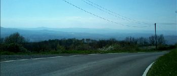
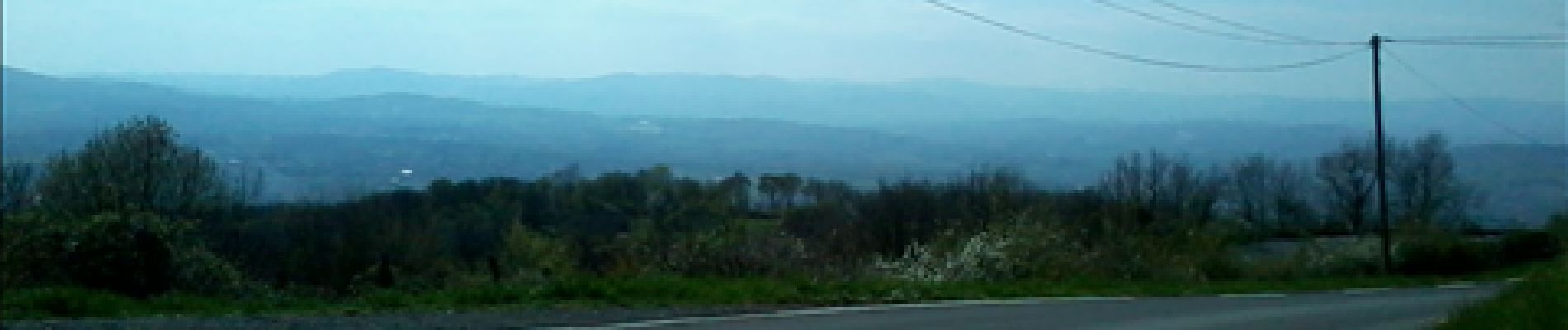
Randonnée V.T.T. de 19,6 km à découvrir à Auvergne-Rhône-Alpes, Métropole de Lyon, Dardilly. Cette randonnée est proposée par simon.paume.
Description
Randonnée facile mais montées très raide entre Le Puy d'Or et Limonest. Suivre le balisage jaune du dept. du Rhône puis balisage bleu des Monts d'Or
Localisation
Pays :
France
Région :
Auvergne-Rhône-Alpes
Département/Province :
Métropole de Lyon
Commune :
Dardilly
Localité :
Unknown
Départ:(Dec)
Départ:(UTM)
636215 ; 5073932 (31T) N.
Commentaires
Randonnées à proximité
![Randonnée Course à pied Limonest - Monts d'Or - Limonest - Photo](https://media.geolcdn.com/t/375/260/ext.jpg?maxdim=2&url=https%3A%2F%2Fservices.sitytrail.com%2FGeolivesWS%2FDownloadMedia.ashx%3FTrailID%3D118776%26Media%3D12977_1.jpg)
![Course à pied Course à pied](https://static1.geolcdn.com/sitytour/trail-icons/103.png)
Monts d'Or - Limonest
Course à pied
Moyen
(2)
Limonest,
Auvergne-Rhône-Alpes,
Métropole de Lyon,
France
![](/images/other/stat-length.png)
21 km | 32 km-effort
2h 0min
![](https://static1.geolcdn.com/siteimages/upload/files/16400158638029165_repeat_loop_refresh_sync_direction_icon.png)
Oui
![Randonnée Marche Marcy-l'Étoile - 69 Marcy l'Etoile et les Monts du Lyonnais - Photo](https://media.geolcdn.com/t/375/260/ext.jpg?maxdim=2&url=https%3A%2F%2Fstatic1.geolcdn.com%2Fsiteimages%2Fupload%2Ffiles%2F1553511878bg_sport_marche.png)
![Marche Marche](https://static1.geolcdn.com/sitytour/trail-icons/101.png)
69 Marcy l'Etoile et les Monts du Lyonnais
Marche
Moyen
(1)
Marcy-l'Étoile,
Auvergne-Rhône-Alpes,
Métropole de Lyon,
France
![](/images/other/stat-length.png)
22 km | 30 km-effort
5h 0min
![](https://static1.geolcdn.com/siteimages/upload/files/16400158638029165_repeat_loop_refresh_sync_direction_icon.png)
Oui
![Randonnée Marche Dommartin - A_DOMMARTIN 69380 Civrieux - Marand - Photo](https://media.geolcdn.com/t/375/260/ext.jpg?maxdim=2&url=https%3A%2F%2Fstatic1.geolcdn.com%2Fsiteimages%2Fupload%2Ffiles%2F1553511878bg_sport_marche.png)
![Marche Marche](https://static1.geolcdn.com/sitytour/trail-icons/101.png)
A_DOMMARTIN 69380 Civrieux - Marand
Marche
Facile
(1)
Dommartin,
Auvergne-Rhône-Alpes,
Rhône,
France
![](/images/other/stat-length.png)
10,1 km | 12,2 km-effort
3h 0min
![](https://static1.geolcdn.com/siteimages/upload/files/16400158638029165_repeat_loop_refresh_sync_direction_icon.png)
Oui
![Randonnée V.T.T. Lyon - Monts d'Or_02 - Photo](https://media.geolcdn.com/t/375/260/ext.jpg?maxdim=2&url=https%3A%2F%2Fstatic1.geolcdn.com%2Fsiteimages%2Fupload%2Ffiles%2F1524743154velo.jpg)
![V.T.T. V.T.T.](https://static1.geolcdn.com/sitytour/trail-icons/202.png)
Monts d'Or_02
V.T.T.
Moyen
(2)
Lyon,
Auvergne-Rhône-Alpes,
Métropole de Lyon,
France
![](/images/other/stat-length.png)
32 km | 45 km-effort
2h 54min
![](https://static1.geolcdn.com/siteimages/upload/files/16400158638029165_repeat_loop_refresh_sync_direction_icon.png)
Oui
![Randonnée V.T.T. Dardilly - Mont Verdun 2 - Photo](https://media.geolcdn.com/t/375/260/ext.jpg?maxdim=2&url=https%3A%2F%2Fstatic1.geolcdn.com%2Fsiteimages%2Fupload%2Ffiles%2F1524743154velo.jpg)
![V.T.T. V.T.T.](https://static1.geolcdn.com/sitytour/trail-icons/202.png)
Mont Verdun 2
V.T.T.
Moyen
(1)
Dardilly,
Auvergne-Rhône-Alpes,
Métropole de Lyon,
France
![](/images/other/stat-length.png)
17,9 km | 24 km-effort
1h 38min
![](https://static1.geolcdn.com/siteimages/upload/files/16400158638029165_repeat_loop_refresh_sync_direction_icon.png)
Oui
![Randonnée V.T.T. La Tour-de-Salvagny - La Tourelloise 2011 30km - Photo](https://media.geolcdn.com/t/375/260/ext.jpg?maxdim=2&url=https%3A%2F%2Fstatic1.geolcdn.com%2Fsiteimages%2Fupload%2Ffiles%2F1524743154velo.jpg)
![V.T.T. V.T.T.](https://static1.geolcdn.com/sitytour/trail-icons/202.png)
La Tourelloise 2011 30km
V.T.T.
Difficile
(1)
La Tour-de-Salvagny,
Auvergne-Rhône-Alpes,
Métropole de Lyon,
France
![](/images/other/stat-length.png)
30 km | 42 km-effort
2h 30min
![](https://static1.geolcdn.com/siteimages/upload/files/16400158638029165_repeat_loop_refresh_sync_direction_icon.png)
Oui
![Randonnée Marche Limonest - Tour de Limonest - Photo](https://media.geolcdn.com/t/375/260/ext.jpg?maxdim=2&url=https%3A%2F%2Fstatic1.geolcdn.com%2Fsiteimages%2Fupload%2Ffiles%2F1553511878bg_sport_marche.png)
![Marche Marche](https://static1.geolcdn.com/sitytour/trail-icons/101.png)
Tour de Limonest
Marche
Moyen
(2)
Limonest,
Auvergne-Rhône-Alpes,
Métropole de Lyon,
France
![](/images/other/stat-length.png)
9,1 km | 13,4 km-effort
2h 15min
![](https://static1.geolcdn.com/siteimages/upload/files/16400158638029165_repeat_loop_refresh_sync_direction_icon.png)
Non
![Randonnée Marche Écully - Le bois de Serres - Photo](https://media.geolcdn.com/t/375/260/d512f125-8af4-4c7f-a25d-89bf9b92124c.jpg&format=jpg&maxdim=2)
![Marche Marche](https://static1.geolcdn.com/sitytour/trail-icons/101.png)
Le bois de Serres
Marche
Facile
Écully,
Auvergne-Rhône-Alpes,
Métropole de Lyon,
France
![](/images/other/stat-length.png)
7 km | 9 km-effort
2h 9min
![](https://static1.geolcdn.com/siteimages/upload/files/16400158638029165_repeat_loop_refresh_sync_direction_icon.png)
Non
![Randonnée Randonnée équestre Limonest - limonest2-hangar par azergues 17k - Photo](https://media.geolcdn.com/t/375/260/ext.jpg?maxdim=2&url=https%3A%2F%2Fstatic1.geolcdn.com%2Fsiteimages%2Fupload%2Ffiles%2F1524743154cheval.jpg)
![Randonnée équestre Randonnée équestre](https://static1.geolcdn.com/sitytour/trail-icons/301.png)
limonest2-hangar par azergues 17k
Randonnée équestre
Moyen
(3)
Limonest,
Auvergne-Rhône-Alpes,
Métropole de Lyon,
France
![](/images/other/stat-length.png)
18,3 km | 21 km-effort
2h 41min
![](https://static1.geolcdn.com/siteimages/upload/files/16400158638029165_repeat_loop_refresh_sync_direction_icon.png)
Non