![](/images/other/stat-length.png)
![Randonnée Course à pied Saint-Lubin-des-Joncherets - Jogging 1h St Jacques de compostelle - Photo](https://media.geolcdn.com/t/1900/400/ext.pjpeg?maxdim=2&url=https%3A%2F%2Fstatic1.geolcdn.com%2Fsiteimages%2Fupload%2Ffiles%2F1524743154running.jpg)
Jogging 1h St Jacques de compostelle
olivier28350
Utilisateur
![Longueur](/images/other/stat-length.png)
Longueur
10,8 km
![Altitude max](https://static1.geolcdn.com/siteimages/upload/files/1508320355ic_sort_altitude_max_24dp.png)
Altitude max
157 m
![Dénivelé positif](https://static1.geolcdn.com/siteimages/upload/files/1508320355ic_sort_den_pos_24dp.png)
Dénivelé positif
127 m
![Km-Effort](/images/other/stat-length.png)
Km-Effort
12,5 km
![Altitude min](https://static1.geolcdn.com/siteimages/upload/files/1508320355ic_sort_altitude_min_24dp.png)
Altitude min
118 m
![Dénivelé négatif](https://static1.geolcdn.com/siteimages/upload/files/1508320355ic_sort_den_neg_24dp.png)
Dénivelé négatif
128 m
![Boucle](https://static1.geolcdn.com/siteimages/upload/files/16400158638029165_repeat_loop_refresh_sync_direction_icon.png)
Boucle
Oui
Date de création :
2014-12-10 00:00:00.0
Dernière modification :
2014-12-10 00:00:00.0
![Course à pied](https://static1.geolcdn.com/sitytour/trail-icons/103.png)
1h15
Difficulté : Moyen
![Scannez ce code QR pour ouvrir la randonnée dans l'application SityTrail](https://capi.geolives.com/qq0zvz2zws4bq2lad0pu/sitytour/trails/187412/qr.png?size=200)
Application GPS de randonnée GRATUITE
À propos
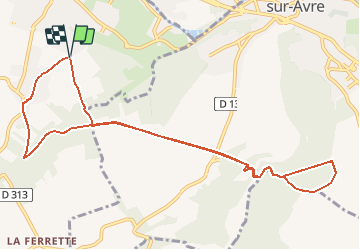
Randonnée Course à pied de 10,8 km à découvrir à Centre-Val de Loire, Eure-et-Loir, Saint-Lubin-des-Joncherets. Cette randonnée est proposée par olivier28350.
Description
Passages en plaine et des dénivelés très prononcés.
Départ et arrivée à la croix Saint Jacques de Compostelle.
Localisation
Pays :
France
Région :
Centre-Val de Loire
Département/Province :
Eure-et-Loir
Commune :
Saint-Lubin-des-Joncherets
Localité :
Unknown
Départ:(Dec)
Départ:(UTM)
367837 ; 5401877 (31U) N.
Commentaires
Randonnées à proximité
![Randonnée Marche Nonancourt - Balade des Crampons - Nonancourt - Photo](https://media.geolcdn.com/t/375/260/ext.jpg?maxdim=2&url=https%3A%2F%2Fservices.sitytrail.com%2FGeolivesWS%2FDownloadMedia.ashx%3FTrailID%3D112543%26Media%3D10752_6.jpg)
![Marche Marche](https://static1.geolcdn.com/sitytour/trail-icons/101.png)
Balade des Crampons - Nonancourt
Marche
Très difficile
(2)
Nonancourt,
Normandie,
Eure,
France
![](/images/other/stat-length.png)
17,5 km | 20 km-effort
4h 25min
![](https://static1.geolcdn.com/siteimages/upload/files/16400158638029165_repeat_loop_refresh_sync_direction_icon.png)
Oui
![Randonnée Marche Saint-Lubin-des-Joncherets - Saint Lubin des Joncherets / Tillières sur Avre (28) - Photo](https://media.geolcdn.com/t/375/260/ext.jpg?maxdim=2&url=https%3A%2F%2Fservices.sitytrail.com%2FGeolivesWS%2FDownloadMedia.ashx%3FTrailID%3D187386%26Media%3D1b9cba9c-d9b6-490c-ba3f-3700dfb78d43.JPG)
![Marche Marche](https://static1.geolcdn.com/sitytour/trail-icons/101.png)
Saint Lubin des Joncherets / Tillières sur Avre (28)
Marche
Très facile
(2)
Saint-Lubin-des-Joncherets,
Centre-Val de Loire,
Eure-et-Loir,
France
![](/images/other/stat-length.png)
11,2 km | 12,9 km-effort
2h 53min
![](https://static1.geolcdn.com/siteimages/upload/files/16400158638029165_repeat_loop_refresh_sync_direction_icon.png)
Non
![Randonnée V.T.T. Saint-Rémy-sur-Avre - Les 3 ponts - Saint-Rémy-sur-Avre - Photo](https://media.geolcdn.com/t/375/260/ext.jpg?maxdim=2&url=https%3A%2F%2Fservices.sitytrail.com%2FGeolivesWS%2FDownloadMedia.ashx%3FTrailID%3D112565%26Media%3D10950_6.jpg)
![V.T.T. V.T.T.](https://static1.geolcdn.com/sitytour/trail-icons/202.png)
Les 3 ponts - Saint-Rémy-sur-Avre
V.T.T.
Facile
Saint-Rémy-sur-Avre,
Centre-Val de Loire,
Eure-et-Loir,
France
![](/images/other/stat-length.png)
16,1 km | 18,8 km-effort
2h 0min
![](https://static1.geolcdn.com/siteimages/upload/files/16400158638029165_repeat_loop_refresh_sync_direction_icon.png)
Oui
![Randonnée Marche Nonancourt - Nonancourt(Ouest)-Acon - Photo](https://media.geolcdn.com/t/375/260/ext.jpg?maxdim=2&url=https%3A%2F%2Fstatic1.geolcdn.com%2Fsiteimages%2Fupload%2Ffiles%2F1553511878bg_sport_marche.png)
![Marche Marche](https://static1.geolcdn.com/sitytour/trail-icons/101.png)
Nonancourt(Ouest)-Acon
Marche
Moyen
Nonancourt,
Normandie,
Eure,
France
![](/images/other/stat-length.png)
24 km | 27 km-effort
6h 0min
![](https://static1.geolcdn.com/siteimages/upload/files/16400158638029165_repeat_loop_refresh_sync_direction_icon.png)
Oui
![Randonnée V.T.T. Saint-Rémy-sur-Avre - Vallée de l' Avre - Photo](https://media.geolcdn.com/t/375/260/ext.jpg?maxdim=2&url=https%3A%2F%2Fstatic1.geolcdn.com%2Fsiteimages%2Fupload%2Ffiles%2F1524743154velo.jpg)
![V.T.T. V.T.T.](https://static1.geolcdn.com/sitytour/trail-icons/202.png)
Vallée de l' Avre
V.T.T.
Moyen
Saint-Rémy-sur-Avre,
Centre-Val de Loire,
Eure-et-Loir,
France
![](/images/other/stat-length.png)
33 km | 40 km-effort
2h 0min
![](https://static1.geolcdn.com/siteimages/upload/files/16400158638029165_repeat_loop_refresh_sync_direction_icon.png)
Oui
![Randonnée Marche Nonancourt - nonancourt - Photo](https://media.geolcdn.com/t/375/260/ext.jpg?maxdim=2&url=https%3A%2F%2Fstatic1.geolcdn.com%2Fsiteimages%2Fupload%2Ffiles%2F1553511878bg_sport_marche.png)
![Marche Marche](https://static1.geolcdn.com/sitytour/trail-icons/101.png)
![Randonnée Marche Saint-Lubin-des-Joncherets - st Lubin - Photo](https://media.geolcdn.com/t/375/260/ext.jpg?maxdim=2&url=https%3A%2F%2Fstatic1.geolcdn.com%2Fsiteimages%2Fupload%2Ffiles%2F1553511878bg_sport_marche.png)
![Marche Marche](https://static1.geolcdn.com/sitytour/trail-icons/101.png)
st Lubin
Marche
Moyen
Saint-Lubin-des-Joncherets,
Centre-Val de Loire,
Eure-et-Loir,
France
![](/images/other/stat-length.png)
7,8 km | 9 km-effort
2h 2min
![](https://static1.geolcdn.com/siteimages/upload/files/16400158638029165_repeat_loop_refresh_sync_direction_icon.png)
Oui
![Randonnée Marche Saint-Lubin-des-Joncherets - 2022_04_St Lubin_Vallée de l'Avre - Photo](https://media.geolcdn.com/t/375/260/ext.jpg?maxdim=2&url=https%3A%2F%2Fstatic1.geolcdn.com%2Fsiteimages%2Fupload%2Ffiles%2F1553511878bg_sport_marche.png)
![Marche Marche](https://static1.geolcdn.com/sitytour/trail-icons/101.png)
2022_04_St Lubin_Vallée de l'Avre
Marche
Très difficile
Saint-Lubin-des-Joncherets,
Centre-Val de Loire,
Eure-et-Loir,
France
![](/images/other/stat-length.png)
17,3 km | 19,8 km-effort
4h 0min
![](https://static1.geolcdn.com/siteimages/upload/files/16400158638029165_repeat_loop_refresh_sync_direction_icon.png)
Oui
![Randonnée Marche Escorpain - Escorpain 16.17 - Photo](https://media.geolcdn.com/t/375/260/ext.jpg?maxdim=2&url=https%3A%2F%2Fstatic1.geolcdn.com%2Fsiteimages%2Fupload%2Ffiles%2F1553511878bg_sport_marche.png)
![Marche Marche](https://static1.geolcdn.com/sitytour/trail-icons/101.png)
Escorpain 16.17
Marche
Facile
Escorpain,
Centre-Val de Loire,
Eure-et-Loir,
France
![](/images/other/stat-length.png)
16,2 km | 18,7 km-effort
Inconnu
![](https://static1.geolcdn.com/siteimages/upload/files/16400158638029165_repeat_loop_refresh_sync_direction_icon.png)
Oui