![](/images/other/stat-length.png)
![Randonnée Autre activité Hérémence - Mont Blava, Cabane de Prafleuri [loop/boucle/Rundwand.] - Photo](https://media.geolcdn.com/t/1900/400/ext.pjpeg?maxdim=2&url=https%3A%2F%2Fstatic1.geolcdn.com%2Fsiteimages%2Fupload%2Ffiles%2F1545311037marcheuse_200dpi.jpg)
Mont Blava, Cabane de Prafleuri [loop/boucle/Rundwand.]
pnoth
Utilisateur
![Longueur](/images/other/stat-length.png)
Longueur
9,8 km
![Altitude max](https://static1.geolcdn.com/siteimages/upload/files/1508320355ic_sort_altitude_max_24dp.png)
Altitude max
2913 m
![Dénivelé positif](https://static1.geolcdn.com/siteimages/upload/files/1508320355ic_sort_den_pos_24dp.png)
Dénivelé positif
674 m
![Km-Effort](/images/other/stat-length.png)
Km-Effort
18,8 km
![Altitude min](https://static1.geolcdn.com/siteimages/upload/files/1508320355ic_sort_altitude_min_24dp.png)
Altitude min
2303 m
![Dénivelé négatif](https://static1.geolcdn.com/siteimages/upload/files/1508320355ic_sort_den_neg_24dp.png)
Dénivelé négatif
676 m
![Boucle](https://static1.geolcdn.com/siteimages/upload/files/16400158638029165_repeat_loop_refresh_sync_direction_icon.png)
Boucle
Oui
Date de création :
2014-12-11 00:00:00.0
Dernière modification :
2014-12-11 00:00:00.0
![Autre activité](https://static1.geolcdn.com/sitytour/trail-icons/900.png)
--
Difficulté : Inconnu
![Scannez ce code QR pour ouvrir la randonnée dans l'application SityTrail](https://capi.geolives.com/qq0zvz2zws4bq2lad0pu/sitytour/trails/18713/qr.png?size=200)
Application GPS de randonnée GRATUITE
À propos
Randonnée Autre activité de 9,8 km à découvrir à Valais, Hérens, Hérémence. Cette randonnée est proposée par pnoth.
Description
English: http://www.noth.ch/h0134_e.html
Français: http://www.noth.ch/h0134_f.html
Deutsch: http://www.noth.ch/h0134_d.html
Localisation
Pays :
Suisse
Région :
Valais
Département/Province :
Hérens
Commune :
Hérémence
Localité :
Unknown
Départ:(Dec)
Départ:(UTM)
376100 ; 5104274 (32T) N.
Commentaires
Randonnées à proximité
![Randonnée Marche Hérémence - La Haute Route : J4 - Photo](https://media.geolcdn.com/t/375/260/76ee7fac-30db-42d5-834e-37a8215569d8.jpg&format=jpg&maxdim=2)
![Marche Marche](https://static1.geolcdn.com/sitytour/trail-icons/101.png)
La Haute Route : J4
Marche
Difficile
Hérémence,
Valais,
Hérens,
Suisse
![](/images/other/stat-length.png)
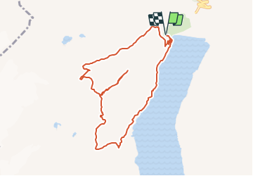
18,3 km | 31 km-effort
5h 31min
![](https://static1.geolcdn.com/siteimages/upload/files/16400158638029165_repeat_loop_refresh_sync_direction_icon.png)
Non
![Randonnée A pied Hérémence - Le sentier des bouquetins - Photo](https://media.geolcdn.com/t/375/260/d667c5e4-6a47-4bd4-95c7-4007d7b01461.jpeg&format=jpg&maxdim=2)
![A pied A pied](https://static1.geolcdn.com/sitytour/trail-icons/100.png)
Le sentier des bouquetins
A pied
Facile
Hérémence,
Valais,
Hérens,
Suisse
![](/images/other/stat-length.png)
8,3 km | 16,6 km-effort
3h 46min
![](https://static1.geolcdn.com/siteimages/upload/files/16400158638029165_repeat_loop_refresh_sync_direction_icon.png)
Oui
![Randonnée Marche Hérémence - CHX ZRMT Étape 5 de Cabane de prafleuri à Arolla - Photo](https://media.geolcdn.com/t/375/260/ext.jpg?maxdim=2&url=https%3A%2F%2Fservices.sitytrail.com%2FGeolivesWS%2FDownloadMedia.ashx%3FTrailID%3D635932%26Media%3Dfix__20160917122629.jpg)
![Marche Marche](https://static1.geolcdn.com/sitytour/trail-icons/101.png)
CHX ZRMT Étape 5 de Cabane de prafleuri à Arolla
Marche
Moyen
Hérémence,
Valais,
Hérens,
Suisse
![](/images/other/stat-length.png)
18,8 km | 32 km-effort
6h 31min
![](https://static1.geolcdn.com/siteimages/upload/files/16400158638029165_repeat_loop_refresh_sync_direction_icon.png)
Non
![Randonnée Marche nordique Hérémence - tour du lac de la grande Dixence - Photo](https://media.geolcdn.com/t/375/260/46c41aba-dd1b-40b9-bedf-56525ffd86be.jpg&format=jpg&maxdim=2)
![Marche nordique Marche nordique](https://static1.geolcdn.com/sitytour/trail-icons/102.png)
tour du lac de la grande Dixence
Marche nordique
Très facile
Hérémence,
Valais,
Hérens,
Suisse
![](/images/other/stat-length.png)
10,9 km | 19,2 km-effort
2h 33min
![](https://static1.geolcdn.com/siteimages/upload/files/16400158638029165_repeat_loop_refresh_sync_direction_icon.png)
Oui
![Randonnée Sports d'hiver Hérémence - Verbier/Zermat (Cabane Prafleuri- Cabane des Dix) - Photo](https://media.geolcdn.com/t/375/260/ext.jpg?maxdim=2&url=https%3A%2F%2Fstatic1.geolcdn.com%2Fsiteimages%2Fupload%2Ffiles%2F1524743153ski.jpg)
![Sports d'hiver Sports d'hiver](https://static1.geolcdn.com/sitytour/trail-icons/500.png)
Verbier/Zermat (Cabane Prafleuri- Cabane des Dix)
Sports d'hiver
Très facile
Hérémence,
Valais,
Hérens,
Suisse
![](/images/other/stat-length.png)
11 km | 21 km-effort
4h 0min
![](https://static1.geolcdn.com/siteimages/upload/files/16400158638029165_repeat_loop_refresh_sync_direction_icon.png)
Non
![Randonnée Marche Hérémence - vs_hike674b - Photo](https://media.geolcdn.com/t/375/260/ext.jpg?maxdim=2&url=https%3A%2F%2Fstatic1.geolcdn.com%2Fsiteimages%2Fupload%2Ffiles%2F1553511878bg_sport_marche.png)
![Marche Marche](https://static1.geolcdn.com/sitytour/trail-icons/101.png)
vs_hike674b
Marche
Très facile
Hérémence,
Valais,
Hérens,
Suisse
![](/images/other/stat-length.png)
15,1 km | 26 km-effort
4h 32min
![](https://static1.geolcdn.com/siteimages/upload/files/16400158638029165_repeat_loop_refresh_sync_direction_icon.png)
Non
![Randonnée Marche nordique Hérémence - lac des dix - Photo](https://media.geolcdn.com/t/375/260/ext.jpg?maxdim=2&url=https%3A%2F%2Fstatic1.geolcdn.com%2Fsiteimages%2Fupload%2Ffiles%2F1545311037marcheuse_200dpi.jpg)
![Marche nordique Marche nordique](https://static1.geolcdn.com/sitytour/trail-icons/102.png)
lac des dix
Marche nordique
Moyen
Hérémence,
Valais,
Hérens,
Suisse
![](/images/other/stat-length.png)
11,3 km | 23 km-effort
5h 38min
![](https://static1.geolcdn.com/siteimages/upload/files/16400158638029165_repeat_loop_refresh_sync_direction_icon.png)
Oui
![Randonnée Autre activité Hérémence - pra fleuri les dix - Photo](https://media.geolcdn.com/t/375/260/ext.jpg?maxdim=2&url=https%3A%2F%2Fstatic1.geolcdn.com%2Fsiteimages%2Fupload%2Ffiles%2F1545311037marcheuse_200dpi.jpg)
![Autre activité Autre activité](https://static1.geolcdn.com/sitytour/trail-icons/900.png)
pra fleuri les dix
Autre activité
Très facile
Hérémence,
Valais,
Hérens,
Suisse
![](/images/other/stat-length.png)
8,3 km | 18,6 km-effort
5h 36min
![](https://static1.geolcdn.com/siteimages/upload/files/16400158638029165_repeat_loop_refresh_sync_direction_icon.png)
Non
![Randonnée Marche Hérémence - Dixence - Photo](https://media.geolcdn.com/t/375/260/ext.jpg?maxdim=2&url=https%3A%2F%2Fstatic1.geolcdn.com%2Fsiteimages%2Fupload%2Ffiles%2F1553511878bg_sport_marche.png)
![Marche Marche](https://static1.geolcdn.com/sitytour/trail-icons/101.png)