![](/images/other/stat-length.png)
![Randonnée Sports d'hiver L'Abbaye - Tour du Lac de Joux (par les hauts) - Photo](https://media.geolcdn.com/t/1900/400/ext.pjpeg?maxdim=2&url=https%3A%2F%2Fstatic1.geolcdn.com%2Fsiteimages%2Fupload%2Ffiles%2F1524743153ski.jpg)
Tour du Lac de Joux (par les hauts)
Romrando
Utilisateur
![Longueur](/images/other/stat-length.png)
![Altitude max](https://static1.geolcdn.com/siteimages/upload/files/1508320355ic_sort_altitude_max_24dp.png)
![Dénivelé positif](https://static1.geolcdn.com/siteimages/upload/files/1508320355ic_sort_den_pos_24dp.png)
![Km-Effort](/images/other/stat-length.png)
![Altitude min](https://static1.geolcdn.com/siteimages/upload/files/1508320355ic_sort_altitude_min_24dp.png)
![Dénivelé négatif](https://static1.geolcdn.com/siteimages/upload/files/1508320355ic_sort_den_neg_24dp.png)
![Boucle](https://static1.geolcdn.com/siteimages/upload/files/16400158638029165_repeat_loop_refresh_sync_direction_icon.png)
![Sports d'hiver](https://static1.geolcdn.com/sitytour/trail-icons/500.png)
--
Difficulté : Inconnu
![Scannez ce code QR pour ouvrir la randonnée dans l'application SityTrail](https://capi.geolives.com/qq0zvz2zws4bq2lad0pu/sitytour/trails/18551/qr.png?size=200)
Application GPS de randonnée GRATUITE
À propos
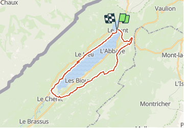
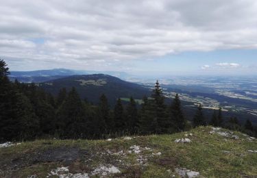
Randonnée Sports d'hiver de 25 km à découvrir à Vaud, District du Jura-Nord vaudois, L'Abbaye. Cette randonnée est proposée par Romrando.
Description
Source:geocities.com/romrando
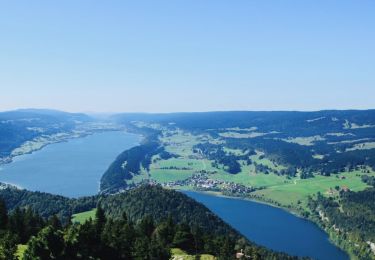
Depuis Le Pont prendre la route jusqu''à l''entée des Charbonnières et prendre à gauche dès que possible un chemin, franchir la voie ferrée et gagner la crête (>>>) au point 1080 m (vélo à pousser parfois). De là on suit la crête par un chemin plus ou moins bon, assez chaotique par moments, boueux parfois. On passe au S du Lieu puis toujours par la crête on rejoint 1 km plus loin la voie ferrée. De là descendre par un chemin forestier en deux S et rejoindre le bord du lac (très beau coin à pic nic et baignade sur une plage de cailloux).
On longe ensuite le bord du lac très fréquenté le week-end jusqu''à la Golisse puis on passe sur l''autre rive par une route qui rejoint la RC Le Brassus- L''Abbaye.
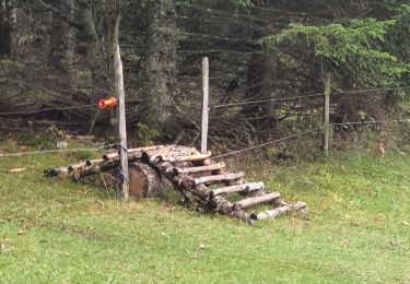
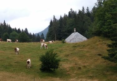
De là 100 m à gauche puis tout de suite à droite (>>>) on s''élève par une petite route sur environ 1 km puis on prend à gauche vers le N un chemin qui mène à la ferme "Les Fives" . De là par un mauvais chemin d''abord à plat, on franchit un bois et un ruisseau (souvent boueux) puis on rejoint par une légère montée (vélo à pousser si nécessaire) la ferme de "Jolimont". Ensuite toujours vers le NE un chemin à plat vous mène à une autre ferme puis rejoint une petite route goudronnée. Suivre celle-ci vers le NE (>>). Au croisement du "Chalet Neuf" on continue tout droit vers le couvert de la Coche puis on rejoint (>) la ferme de "La Coche".
De là à travers champ (vélo à pousser), dans une direction ENE sur 1 km, on rejoint un chemin que l''on descend sur 1 km NNE jusqu''à un croisement.
Continuer à descendre dans un vallon sur 1 km (assez raide) puis à un croisement partir à droite vers le NE et suivre à flanc de montagne jusqu''à une petite route qui vous amène tout près de Petra Félix. Rejoindre alors Le Pont par la RC.
Localisation
Commentaires
Randonnées à proximité
![Randonnée A pied Vallorbe - Mont d'Orzeires - Le Pont Gare - Photo](https://media.geolcdn.com/t/375/260/7e9156be-5722-477c-ab77-407a4f623ffb.jpeg&format=jpg&maxdim=2)
![A pied A pied](https://static1.geolcdn.com/sitytour/trail-icons/100.png)
A pied
![](/images/other/stat-length.png)
![](https://static1.geolcdn.com/siteimages/upload/files/16400158638029165_repeat_loop_refresh_sync_direction_icon.png)
![Randonnée A pied L'Abbaye - Pétra Félix-Dent du Vaulion - Photo](https://media.geolcdn.com/t/375/260/791319e2-c645-47ad-9892-4c78de70e46d.jpeg&format=jpg&maxdim=2)
![A pied A pied](https://static1.geolcdn.com/sitytour/trail-icons/100.png)
A pied
![](/images/other/stat-length.png)
![](https://static1.geolcdn.com/siteimages/upload/files/16400158638029165_repeat_loop_refresh_sync_direction_icon.png)
![Randonnée A pied Vallorbe - Saigne Geret-Les Revines - Photo](https://media.geolcdn.com/t/375/260/7e9156be-5722-477c-ab77-407a4f623ffb.jpeg&format=jpg&maxdim=2)
![A pied A pied](https://static1.geolcdn.com/sitytour/trail-icons/100.png)
A pied
![](/images/other/stat-length.png)
![](https://static1.geolcdn.com/siteimages/upload/files/16400158638029165_repeat_loop_refresh_sync_direction_icon.png)
![Randonnée Marche L'Abbaye - La Dent de Vaulion - Photo](https://media.geolcdn.com/t/375/260/d5e685b7-4a94-4c58-8eef-781dbd85a043.jpg&format=jpg&maxdim=2)
![Marche Marche](https://static1.geolcdn.com/sitytour/trail-icons/101.png)
Marche
![](/images/other/stat-length.png)
![](https://static1.geolcdn.com/siteimages/upload/files/16400158638029165_repeat_loop_refresh_sync_direction_icon.png)
![Randonnée Raquettes à neige L'Abbaye - Le Pont dent de Vaulion Suisse - Photo](https://media.geolcdn.com/t/375/260/9e2200ad-9d42-4562-b83d-ca6468e63af4.jpg&format=jpg&maxdim=2)
![Raquettes à neige Raquettes à neige](https://static1.geolcdn.com/sitytour/trail-icons/504.png)
Raquettes à neige
![](/images/other/stat-length.png)
![](https://static1.geolcdn.com/siteimages/upload/files/16400158638029165_repeat_loop_refresh_sync_direction_icon.png)
![Randonnée Marche Mont-la-Ville - Col du Mollendruz- Châtel12.08.16 - Photo](https://media.geolcdn.com/t/375/260/ext.jpg?maxdim=2&url=https%3A%2F%2Fservices.sitytrail.com%2FGeolivesWS%2FDownloadMedia.ashx%3FTrailID%3D613380%26Media%3D43a7cf82-b29c-47b6-b70e-4ce03287cc7c.jpg)
![Marche Marche](https://static1.geolcdn.com/sitytour/trail-icons/101.png)
Marche
![](/images/other/stat-length.png)
![](https://static1.geolcdn.com/siteimages/upload/files/16400158638029165_repeat_loop_refresh_sync_direction_icon.png)
![Randonnée Marche Mont-la-Ville - Jura Club Grand Tour belle vue lac leman - Photo](https://media.geolcdn.com/t/375/260/ef457377-2225-4112-a04a-847f4d6a388b.jpg&format=jpg&maxdim=2)
![Marche Marche](https://static1.geolcdn.com/sitytour/trail-icons/101.png)
Marche
![](/images/other/stat-length.png)
![](https://static1.geolcdn.com/siteimages/upload/files/16400158638029165_repeat_loop_refresh_sync_direction_icon.png)
![Randonnée A pied Vaulion - Sur le Voué- - Photo](https://media.geolcdn.com/t/375/260/ext.jpg?maxdim=2&url=https%3A%2F%2Fstatic1.geolcdn.com%2Fsiteimages%2Fupload%2Ffiles%2F1545311037marcheuse_200dpi.jpg)
![A pied A pied](https://static1.geolcdn.com/sitytour/trail-icons/100.png)
A pied
![](/images/other/stat-length.png)
![](https://static1.geolcdn.com/siteimages/upload/files/16400158638029165_repeat_loop_refresh_sync_direction_icon.png)
![Randonnée Marche Vallorbe - Vallorbe La Dent du Vaulion Fort du Pré Giroud 4 août 2020 CAF - Photo](https://media.geolcdn.com/t/375/260/51f06875-567a-49a6-9929-f56fedfeebf9.jpg&format=jpg&maxdim=2)
![Marche Marche](https://static1.geolcdn.com/sitytour/trail-icons/101.png)
Marche
![](/images/other/stat-length.png)
![](https://static1.geolcdn.com/siteimages/upload/files/16400158638029165_repeat_loop_refresh_sync_direction_icon.png)