![](/images/other/stat-length.png)
![Randonnée Marche Mauzé-sur-le-Mignon - Mauzé sur le Mignon village - Photo](https://media.geolcdn.com/t/1900/400/ext.pjpeg?maxdim=2&url=https%3A%2F%2Fservices.sitytrail.com%2FGeolivesWS%2FDownloadMedia.ashx%3FTrailID%3D181572%26Media%3D20130326163958.jpeg)
Mauzé sur le Mignon village
olaze
Utilisateur
![Longueur](/images/other/stat-length.png)
Longueur
10,7 km
![Altitude max](https://static1.geolcdn.com/siteimages/upload/files/1508320355ic_sort_altitude_max_24dp.png)
Altitude max
24 m
![Dénivelé positif](https://static1.geolcdn.com/siteimages/upload/files/1508320355ic_sort_den_pos_24dp.png)
Dénivelé positif
55 m
![Km-Effort](/images/other/stat-length.png)
Km-Effort
11,5 km
![Altitude min](https://static1.geolcdn.com/siteimages/upload/files/1508320355ic_sort_altitude_min_24dp.png)
Altitude min
5 m
![Dénivelé négatif](https://static1.geolcdn.com/siteimages/upload/files/1508320355ic_sort_den_neg_24dp.png)
Dénivelé négatif
56 m
![Boucle](https://static1.geolcdn.com/siteimages/upload/files/16400158638029165_repeat_loop_refresh_sync_direction_icon.png)
Boucle
Oui
Date de création :
2016-03-09 00:00:00.0
Dernière modification :
2016-03-09 00:00:00.0
![Marche](https://static1.geolcdn.com/sitytour/trail-icons/101.png)
2h32
Difficulté : Facile
![Scannez ce code QR pour ouvrir la randonnée dans l'application SityTrail](https://capi.geolives.com/qq0zvz2zws4bq2lad0pu/sitytour/trails/181572/qr.png?size=200)
Application GPS de randonnée GRATUITE
À propos
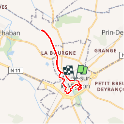
Randonnée Marche de 10,7 km à découvrir à Nouvelle-Aquitaine, Deux-Sèvres, Mauzé-sur-le-Mignon. Cette randonnée est proposée par olaze.
Description
Départ parking de léglise.
Promenade dans village.Le long du Mignon, jusque l''écluse de Chaban.
Club rando Bessines 03/2013
Localisation
Pays :
France
Région :
Nouvelle-Aquitaine
Département/Province :
Deux-Sèvres
Commune :
Mauzé-sur-le-Mignon
Localité :
Unknown
Départ:(Dec)
Départ:(UTM)
679720 ; 5118493 (30T) N.
Commentaires
Randonnées à proximité
![Randonnée Marche Cramchaban - cramchaban - Photo](https://media.geolcdn.com/t/375/260/fe3a5a2e-3599-4cce-ab14-3687773f18b2.jpg&format=jpg&maxdim=2)
![Marche Marche](https://static1.geolcdn.com/sitytour/trail-icons/101.png)
cramchaban
Marche
Très facile
Cramchaban,
Nouvelle-Aquitaine,
Charente-Maritime,
France
![](/images/other/stat-length.png)
8,3 km | 8,7 km-effort
2h 20min
![](https://static1.geolcdn.com/siteimages/upload/files/16400158638029165_repeat_loop_refresh_sync_direction_icon.png)
Oui
![Randonnée Marche Le Bourdet - Le Bourdet - 10km - Photo](https://media.geolcdn.com/t/375/260/ext.jpg?maxdim=2&url=https%3A%2F%2Fservices.sitytrail.com%2FGeolivesWS%2FDownloadMedia.ashx%3FTrailID%3D197620%26Media%3D20130611144155.jpeg)
![Marche Marche](https://static1.geolcdn.com/sitytour/trail-icons/101.png)
Le Bourdet - 10km
Marche
Facile
Le Bourdet,
Nouvelle-Aquitaine,
Deux-Sèvres,
France
![](/images/other/stat-length.png)
10,5 km | 11,1 km-effort
2h 28min
![](https://static1.geolcdn.com/siteimages/upload/files/16400158638029165_repeat_loop_refresh_sync_direction_icon.png)
Oui
![Randonnée Marche Cramchaban - Cramchaban - Photo](https://media.geolcdn.com/t/375/260/ext.jpg?maxdim=2&url=https%3A%2F%2Fstatic1.geolcdn.com%2Fsiteimages%2Fupload%2Ffiles%2F1553511878bg_sport_marche.png)
![Marche Marche](https://static1.geolcdn.com/sitytour/trail-icons/101.png)
Cramchaban
Marche
Très difficile
Cramchaban,
Nouvelle-Aquitaine,
Charente-Maritime,
France
![](/images/other/stat-length.png)
52 km | 56 km-effort
4h 3min
![](https://static1.geolcdn.com/siteimages/upload/files/16400158638029165_repeat_loop_refresh_sync_direction_icon.png)
Non
![Randonnée Marche Prin-Deyrançon - Prin Deyrançon 2 - Photo](https://media.geolcdn.com/t/375/260/ext.jpg?maxdim=2&url=https%3A%2F%2Fservices.sitytrail.com%2FGeolivesWS%2FDownloadMedia.ashx%3FTrailID%3D934840%26Media%3Dfix__20180327150849.jpg)
![Marche Marche](https://static1.geolcdn.com/sitytour/trail-icons/101.png)
Prin Deyrançon 2
Marche
Facile
Prin-Deyrançon,
Nouvelle-Aquitaine,
Deux-Sèvres,
France
![](/images/other/stat-length.png)
8,4 km | 9,1 km-effort
2h 9min
![](https://static1.geolcdn.com/siteimages/upload/files/16400158638029165_repeat_loop_refresh_sync_direction_icon.png)
Oui
![Randonnée Marche Mauzé-sur-le-Mignon - Mauzé sur Le Mignon .Village - Photo](https://media.geolcdn.com/t/375/260/ext.jpg?maxdim=2&url=https%3A%2F%2Fstatic1.geolcdn.com%2Fsiteimages%2Fupload%2Ffiles%2F1553511878bg_sport_marche.png)
![Marche Marche](https://static1.geolcdn.com/sitytour/trail-icons/101.png)
Mauzé sur Le Mignon .Village
Marche
Facile
Mauzé-sur-le-Mignon,
Nouvelle-Aquitaine,
Deux-Sèvres,
France
![](/images/other/stat-length.png)
9,8 km | 10,5 km-effort
2h 19min
![](https://static1.geolcdn.com/siteimages/upload/files/16400158638029165_repeat_loop_refresh_sync_direction_icon.png)
Oui
![Randonnée Marche Le Bourdet - Le Bourdet . Deux-Sèvres. 79 - Photo](https://media.geolcdn.com/t/375/260/ext.jpg?maxdim=2&url=https%3A%2F%2Fstatic1.geolcdn.com%2Fsiteimages%2Fupload%2Ffiles%2F1553511878bg_sport_marche.png)
![Marche Marche](https://static1.geolcdn.com/sitytour/trail-icons/101.png)
Le Bourdet . Deux-Sèvres. 79
Marche
Facile
Le Bourdet,
Nouvelle-Aquitaine,
Deux-Sèvres,
France
![](/images/other/stat-length.png)
8,6 km | 9,2 km-effort
2h 9min
![](https://static1.geolcdn.com/siteimages/upload/files/16400158638029165_repeat_loop_refresh_sync_direction_icon.png)
Oui
![Randonnée Marche Mauzé-sur-le-Mignon - Mauze sur le Mignon - Photo](https://media.geolcdn.com/t/375/260/ext.jpg?maxdim=2&url=https%3A%2F%2Fstatic1.geolcdn.com%2Fsiteimages%2Fupload%2Ffiles%2F1553511878bg_sport_marche.png)
![Marche Marche](https://static1.geolcdn.com/sitytour/trail-icons/101.png)
Mauze sur le Mignon
Marche
Facile
Mauzé-sur-le-Mignon,
Nouvelle-Aquitaine,
Deux-Sèvres,
France
![](/images/other/stat-length.png)
10,6 km | 11,1 km-effort
2h 25min
![](https://static1.geolcdn.com/siteimages/upload/files/16400158638029165_repeat_loop_refresh_sync_direction_icon.png)
Oui
![Randonnée Marche Saint-Pierre-d'Amilly - Saint-Pierre-d'Amilly - Photo](https://media.geolcdn.com/t/375/260/ext.jpg?maxdim=2&url=https%3A%2F%2Fstatic1.geolcdn.com%2Fsiteimages%2Fupload%2Ffiles%2F1553511878bg_sport_marche.png)
![Marche Marche](https://static1.geolcdn.com/sitytour/trail-icons/101.png)
Saint-Pierre-d'Amilly
Marche
Facile
Saint-Pierre-d'Amilly,
Nouvelle-Aquitaine,
Charente-Maritime,
France
![](/images/other/stat-length.png)
8,8 km | 9,9 km-effort
2h 8min
![](https://static1.geolcdn.com/siteimages/upload/files/16400158638029165_repeat_loop_refresh_sync_direction_icon.png)
Oui
![Randonnée Marche Prin-Deyrançon - Prin-Deyrançon - Photo](https://media.geolcdn.com/t/375/260/ext.jpg?maxdim=2&url=https%3A%2F%2Fstatic1.geolcdn.com%2Fsiteimages%2Fupload%2Ffiles%2F1553511878bg_sport_marche.png)
![Marche Marche](https://static1.geolcdn.com/sitytour/trail-icons/101.png)
Prin-Deyrançon
Marche
Moyen
Prin-Deyrançon,
Nouvelle-Aquitaine,
Deux-Sèvres,
France
![](/images/other/stat-length.png)
8,4 km | 9,1 km-effort
Inconnu
![](https://static1.geolcdn.com/siteimages/upload/files/16400158638029165_repeat_loop_refresh_sync_direction_icon.png)
Oui
gros soucis avec mon galaxy s5. gros carré blanc qui me cache une grosse partie de la carte. appli impossible à utiliser