![](/images/other/stat-length.png)
![Randonnée Marche Aywaille - RB-Lg-15_Harzé - Photo](https://media.geolcdn.com/t/1900/400/ext.pjpeg?maxdim=2&url=https%3A%2F%2Fservices.sitytrail.com%2FGeolivesWS%2FDownloadMedia.ashx%3FTrailID%3D179573%26Media%3D790acd11-a9eb-4644-bdd3-c1540608bba1.jpg)
RB-Lg-15_Harzé
GR Rando
Randonnez sur et autour des GR ® wallons (Sentiers de Grande Randonnée). PRO
![Longueur](/images/other/stat-length.png)
![Altitude max](https://static1.geolcdn.com/siteimages/upload/files/1508320355ic_sort_altitude_max_24dp.png)
![Dénivelé positif](https://static1.geolcdn.com/siteimages/upload/files/1508320355ic_sort_den_pos_24dp.png)
![Km-Effort](/images/other/stat-length.png)
![Altitude min](https://static1.geolcdn.com/siteimages/upload/files/1508320355ic_sort_altitude_min_24dp.png)
![Dénivelé négatif](https://static1.geolcdn.com/siteimages/upload/files/1508320355ic_sort_den_neg_24dp.png)
![Boucle](https://static1.geolcdn.com/siteimages/upload/files/16400158638029165_repeat_loop_refresh_sync_direction_icon.png)
![Marche](https://static1.geolcdn.com/sitytour/trail-icons/101.png)
6h10
Difficulté : Difficile
![Scannez ce code QR pour ouvrir la randonnée dans l'application SityTrail](https://capi.geolives.com/qq0zvz2zws4bq2lad0pu/sitytour/trails/179573/qr.png?size=200)
Application GPS de randonnée GRATUITE
À propos
Randonnée Marche de 22 km à découvrir à Wallonie, Liège, Aywaille. Cette randonnée est proposée par GR Rando.
Description
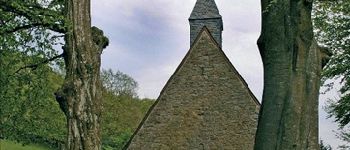
Harzé – chapelle Sainte-Anne – Ernonheid – Grimonster – La Rouge Minière –Collège Saint-Roch – chapelle Saint-Roch – Harzé
Cartographie et documentation
Cartes IGN au 1 : 20 000, 49/5-6 « Hamoir – Ferrières » et 49/7-8 « Harzé – Stoumont ».
Topo-guides du GR 576 « Tour du Condroz liégeois » et GR 15 « Monschau – Martelange ».
Où se désaltérer et se restaurer
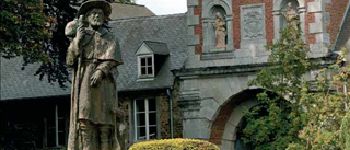
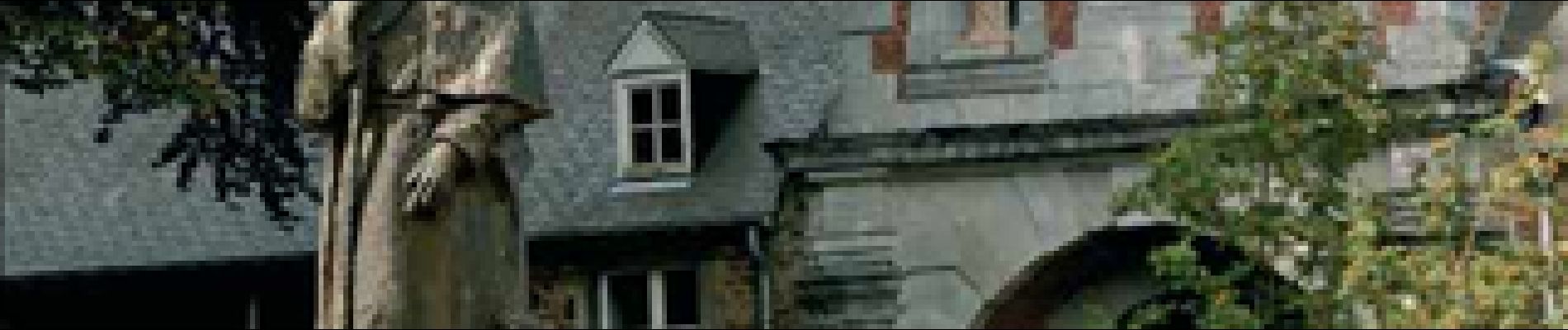
Restaurant au château de Harzé.
Nombreux établissements Horeca dans la commune d’Aywaille à 4,5 kilomètres.
Infos touristiques
Maison du Tourisme Ourthe Vesdre Amblève : rue du Louvegné, 3 – 4920 Remouchamps – Tél. 04 384 35 44 – info.ovatourisme.be – http://www.ovatourisme.be
www.chateau-harze.be (avec notamment le musée de la Meunerie et de la Boulangerie.)
Localisation
Commentaires
Randonnées à proximité
![Randonnée Marche Stoumont - Lorcé, Natura 2000 - Des sites qui valent le détour, Lg13 - Photo](https://media.geolcdn.com/t/375/260/ext.jpg?maxdim=2&url=https%3A%2F%2Fservices.sitytrail.com%2FGeolivesWS%2FDownloadMedia.ashx%3FTrailID%3D182859%26Media%3D43b80b1e-327b-4d3e-accc-f8b9c8a445c2.JPG)
![Marche Marche](https://static1.geolcdn.com/sitytour/trail-icons/101.png)
Marche
![](/images/other/stat-length.png)
![](https://static1.geolcdn.com/siteimages/upload/files/16400158638029165_repeat_loop_refresh_sync_direction_icon.png)
![Randonnée Marche Aywaille - RB-Lg-12_Remouchamps - Photo](https://media.geolcdn.com/t/375/260/ext.jpg?maxdim=2&url=https%3A%2F%2Fservices.sitytrail.com%2FGeolivesWS%2FDownloadMedia.ashx%3FTrailID%3D179570%26Media%3D1074d230-2da3-49cf-8210-a5f6b46fd870.jpg)
![Marche Marche](https://static1.geolcdn.com/sitytour/trail-icons/101.png)
Marche
![](/images/other/stat-length.png)
![](https://static1.geolcdn.com/siteimages/upload/files/16400158638029165_repeat_loop_refresh_sync_direction_icon.png)
![Randonnée Marche Ferrières - Rouge-Minière. Natura 2000, des sites qui valent le détour ! Lg 3 - Photo](https://media.geolcdn.com/t/375/260/ext.jpg?maxdim=2&url=https%3A%2F%2Fservices.sitytrail.com%2FGeolivesWS%2FDownloadMedia.ashx%3FTrailID%3D142641%26Media%3Dc08233b4-27a6-486a-be6b-e1cb0ee623d1.JPG)
![Marche Marche](https://static1.geolcdn.com/sitytour/trail-icons/101.png)
Marche
![](/images/other/stat-length.png)
![](https://static1.geolcdn.com/siteimages/upload/files/16400158638029165_repeat_loop_refresh_sync_direction_icon.png)
![Randonnée Marche Aywaille - aywaille . florzé . martinrive . septroux . aywaille - Photo](https://media.geolcdn.com/t/375/260/8275975a-b8e8-47c1-9fb9-0580e1d080c9.jpg&format=jpg&maxdim=2)
![Marche Marche](https://static1.geolcdn.com/sitytour/trail-icons/101.png)
Marche
![](/images/other/stat-length.png)
![](https://static1.geolcdn.com/siteimages/upload/files/16400158638029165_repeat_loop_refresh_sync_direction_icon.png)
![Randonnée Marche Aywaille - RB-Lg-12_Remouchamps_via-racc-1 - Photo](https://media.geolcdn.com/t/375/260/ext.jpg?maxdim=2&url=https%3A%2F%2Fservices.sitytrail.com%2FGeolivesWS%2FDownloadMedia.ashx%3FTrailID%3D209433%26Media%3D1f1ef83d-c0c7-4521-b15a-02c5e9e7c1f1.jpg)
![Marche Marche](https://static1.geolcdn.com/sitytour/trail-icons/101.png)
Marche
![](/images/other/stat-length.png)
![](https://static1.geolcdn.com/siteimages/upload/files/16400158638029165_repeat_loop_refresh_sync_direction_icon.png)
![Randonnée Marche Aywaille - Aywaille - Kin - Château de Harzé - Awan - Photo](https://media.geolcdn.com/t/375/260/fc604b5e-e950-4941-952b-ecd138cbf420.jpg&format=jpg&maxdim=2)
![Marche Marche](https://static1.geolcdn.com/sitytour/trail-icons/101.png)
Marche
![](/images/other/stat-length.png)
![](https://static1.geolcdn.com/siteimages/upload/files/16400158638029165_repeat_loop_refresh_sync_direction_icon.png)
![Randonnée Marche Aywaille - Remouchamps - Aywaille - Croix de Septroux - Photo](https://media.geolcdn.com/t/375/260/73151627-72a6-4506-ac77-59fc8213a179.jpg&format=jpg&maxdim=2)
![Marche Marche](https://static1.geolcdn.com/sitytour/trail-icons/101.png)
Marche
![](/images/other/stat-length.png)
![](https://static1.geolcdn.com/siteimages/upload/files/16400158638029165_repeat_loop_refresh_sync_direction_icon.png)
![Randonnée Marche Stoumont - lorcé . suf la lienne . Chevron . lorcé - Photo](https://media.geolcdn.com/t/375/260/9599f201-d2ad-4521-ad0a-b4661e5a5ff4.jpg&format=jpg&maxdim=2)
![Marche Marche](https://static1.geolcdn.com/sitytour/trail-icons/101.png)
Marche
![](/images/other/stat-length.png)
![](https://static1.geolcdn.com/siteimages/upload/files/16400158638029165_repeat_loop_refresh_sync_direction_icon.png)
![Randonnée Marche Aywaille - houssonloge . bois du pouhon . trou de bosson . paradis . houssonloge - Photo](https://media.geolcdn.com/t/375/260/8bc033a3-d4f5-4c9f-9bb4-a2d3fb614b59.jpg&format=jpg&maxdim=2)
![Marche Marche](https://static1.geolcdn.com/sitytour/trail-icons/101.png)
Marche
![](/images/other/stat-length.png)
![](https://static1.geolcdn.com/siteimages/upload/files/16400158638029165_repeat_loop_refresh_sync_direction_icon.png)
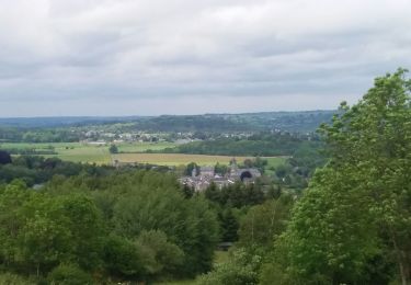
Promenade dans les bois, fort enfermée, peu des vues...
Variée 🥾
hatze
le randoguide nous signalait ?tre hors piste alors que nous ?tions bien sur le gr confirm? par le rep?re. Est ce bien normal?