![](/images/other/stat-length.png)
![Randonnée Marche Carnas - Carnas bois de Paris - Photo](https://media.geolcdn.com/t/1900/400/ext.pjpeg?maxdim=2&url=https%3A%2F%2Fservices.sitytrail.com%2FGeolivesWS%2FDownloadMedia.ashx%3FTrailID%3D178653%26Media%3D20130304133341.jpeg)
Carnas bois de Paris
CAMBON
Utilisateur
![Longueur](/images/other/stat-length.png)
Longueur
12,8 km
![Altitude max](https://static1.geolcdn.com/siteimages/upload/files/1508320355ic_sort_altitude_max_24dp.png)
Altitude max
239 m
![Dénivelé positif](https://static1.geolcdn.com/siteimages/upload/files/1508320355ic_sort_den_pos_24dp.png)
Dénivelé positif
210 m
![Km-Effort](/images/other/stat-length.png)
Km-Effort
15,6 km
![Altitude min](https://static1.geolcdn.com/siteimages/upload/files/1508320355ic_sort_altitude_min_24dp.png)
Altitude min
86 m
![Dénivelé négatif](https://static1.geolcdn.com/siteimages/upload/files/1508320355ic_sort_den_neg_24dp.png)
Dénivelé négatif
209 m
![Boucle](https://static1.geolcdn.com/siteimages/upload/files/16400158638029165_repeat_loop_refresh_sync_direction_icon.png)
Boucle
Oui
Date de création :
2014-12-10 00:00:00.0
Dernière modification :
2014-12-10 00:00:00.0
![Marche](https://static1.geolcdn.com/sitytour/trail-icons/101.png)
4h00
Difficulté : Moyen
![Scannez ce code QR pour ouvrir la randonnée dans l'application SityTrail](https://capi.geolives.com/qq0zvz2zws4bq2lad0pu/sitytour/trails/178653/qr.png?size=200)
Application GPS de randonnée GRATUITE
À propos
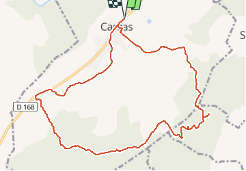
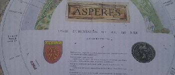
Randonnée Marche de 12,8 km à découvrir à Occitanie, Gard, Carnas. Cette randonnée est proposée par CAMBON.
Description
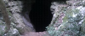
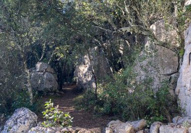
Promenade agréable, prévoir une lampe torche pour descendre avec prudence dans la grotte de Bois de Paris (escaliers aménagés)
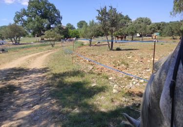
Localisation
Pays :
France
Région :
Occitanie
Département/Province :
Gard
Commune :
Carnas
Localité :
Unknown
Départ:(Dec)
Départ:(UTM)
579593 ; 4853883 (31T) N.
Commentaires
Randonnées à proximité
![Randonnée Randonnée équestre Orthoux-Sérignac-Quilhan - mas bas - corconnes en boucle - Photo](https://media.geolcdn.com/t/375/260/debc9152-3802-423a-8c6a-1db256dabcad.jpg&format=jpg&maxdim=2)
![Randonnée équestre Randonnée équestre](https://static1.geolcdn.com/sitytour/trail-icons/301.png)
mas bas - corconnes en boucle
Randonnée équestre
Moyen
Orthoux-Sérignac-Quilhan,
Occitanie,
Gard,
France
![](/images/other/stat-length.png)
22 km | 26 km-effort
4h 51min
![](https://static1.geolcdn.com/siteimages/upload/files/16400158638029165_repeat_loop_refresh_sync_direction_icon.png)
Oui
![Randonnée Marche Saint-Clément - Le bois de Paris - Grotte, Table d'orientation, Oppidum - Photo](https://media.geolcdn.com/t/375/260/ext.jpg?maxdim=2&url=https%3A%2F%2Fstatic1.geolcdn.com%2Fsiteimages%2Fupload%2Ffiles%2F1553511878bg_sport_marche.png)
![Marche Marche](https://static1.geolcdn.com/sitytour/trail-icons/101.png)
Le bois de Paris - Grotte, Table d'orientation, Oppidum
Marche
Moyen
(1)
Saint-Clément,
Occitanie,
Gard,
France
![](/images/other/stat-length.png)
8,2 km | 10,9 km-effort
2h 29min
![](https://static1.geolcdn.com/siteimages/upload/files/16400158638029165_repeat_loop_refresh_sync_direction_icon.png)
Oui
![Randonnée Marche Corconne - 30 corconne - Photo](https://media.geolcdn.com/t/375/260/935d2ba4-5725-4112-bf5b-aad99ed037b4.jpg&format=jpg&maxdim=2)
![Marche Marche](https://static1.geolcdn.com/sitytour/trail-icons/101.png)
![Randonnée Marche Corconne - Corconne et la forêt de Coutach - Photo](https://media.geolcdn.com/t/375/260/ext.jpg?maxdim=2&url=https%3A%2F%2Fstatic1.geolcdn.com%2Fsiteimages%2Fupload%2Ffiles%2F1553511878bg_sport_marche.png)
![Marche Marche](https://static1.geolcdn.com/sitytour/trail-icons/101.png)
Corconne et la forêt de Coutach
Marche
Facile
(2)
Corconne,
Occitanie,
Gard,
France
![](/images/other/stat-length.png)
18,1 km | 25 km-effort
5h 26min
![](https://static1.geolcdn.com/siteimages/upload/files/16400158638029165_repeat_loop_refresh_sync_direction_icon.png)
Oui
![Randonnée Marche Corconne - Corconne - Photo](https://media.geolcdn.com/t/375/260/ext.jpg?maxdim=2&url=https%3A%2F%2Fstatic1.geolcdn.com%2Fsiteimages%2Fupload%2Ffiles%2F1553511878bg_sport_marche.png)
![Marche Marche](https://static1.geolcdn.com/sitytour/trail-icons/101.png)
![Randonnée Marche Corconne - CORCONNE - Photo](https://media.geolcdn.com/t/375/260/cec47011-04b4-4f0a-b521-d4e592fe1993.jpg&format=jpg&maxdim=2)
![Marche Marche](https://static1.geolcdn.com/sitytour/trail-icons/101.png)
![Randonnée Marche Aspères - Aspères - Photo](https://media.geolcdn.com/t/375/260/3aa1cad7-a037-4103-94ea-4f508e99c3ef.jpg&format=jpg&maxdim=2)
![Marche Marche](https://static1.geolcdn.com/sitytour/trail-icons/101.png)
![Randonnée Marche Vacquières - chapelle D'Aleyrac vers vacquieres parc du duc - Photo](https://media.geolcdn.com/t/375/260/1016cbc1-84d7-4082-b269-d91c1919b57d.jpg&format=jpg&maxdim=2)
![Marche Marche](https://static1.geolcdn.com/sitytour/trail-icons/101.png)
chapelle D'Aleyrac vers vacquieres parc du duc
Marche
Difficile
Vacquières,
Occitanie,
Hérault,
France
![](/images/other/stat-length.png)
12,9 km | 15,3 km-effort
3h 28min
![](https://static1.geolcdn.com/siteimages/upload/files/16400158638029165_repeat_loop_refresh_sync_direction_icon.png)
Oui
![Randonnée Marche Aspères - Aspères - Photo](https://media.geolcdn.com/t/375/260/066f7f1d-8ada-4c66-8b3d-d6874a67ba86.jpg&format=jpg&maxdim=2)
![Marche Marche](https://static1.geolcdn.com/sitytour/trail-icons/101.png)
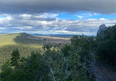
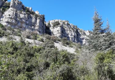
belle randonnées par beau soleil d hiver. vues de la mer er du pic st loup.