![](/images/other/stat-length.png)
Balade à Solre-sur-Sambre
Desrumaux
Utilisateur GUIDE
![Longueur](/images/other/stat-length.png)
![Altitude max](https://static1.geolcdn.com/siteimages/upload/files/1508320355ic_sort_altitude_max_24dp.png)
![Dénivelé positif](https://static1.geolcdn.com/siteimages/upload/files/1508320355ic_sort_den_pos_24dp.png)
![Km-Effort](/images/other/stat-length.png)
![Altitude min](https://static1.geolcdn.com/siteimages/upload/files/1508320355ic_sort_altitude_min_24dp.png)
![Dénivelé négatif](https://static1.geolcdn.com/siteimages/upload/files/1508320355ic_sort_den_neg_24dp.png)
![Boucle](https://static1.geolcdn.com/siteimages/upload/files/16400158638029165_repeat_loop_refresh_sync_direction_icon.png)
![Marche](https://static1.geolcdn.com/sitytour/trail-icons/101.png)
1h20
Difficulté : Très facile
![Scannez ce code QR pour ouvrir la randonnée dans l'application SityTrail](https://capi.geolives.com/qq0zvz2zws4bq2lad0pu/sitytour/trails/175387/qr.png?size=200)
Application GPS de randonnée GRATUITE
À propos
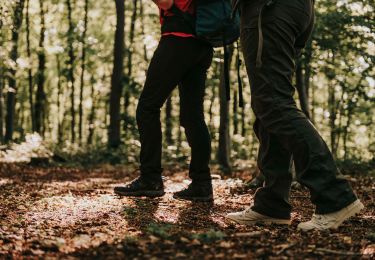
Randonnée Marche de 5,3 km à découvrir à Wallonie, Hainaut, Erquelinnes. Cette randonnée est proposée par Desrumaux.
Description
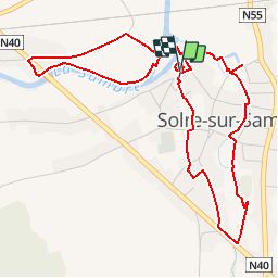
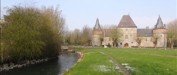
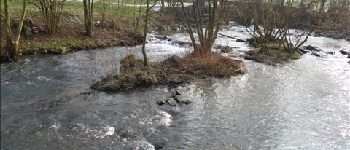
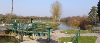
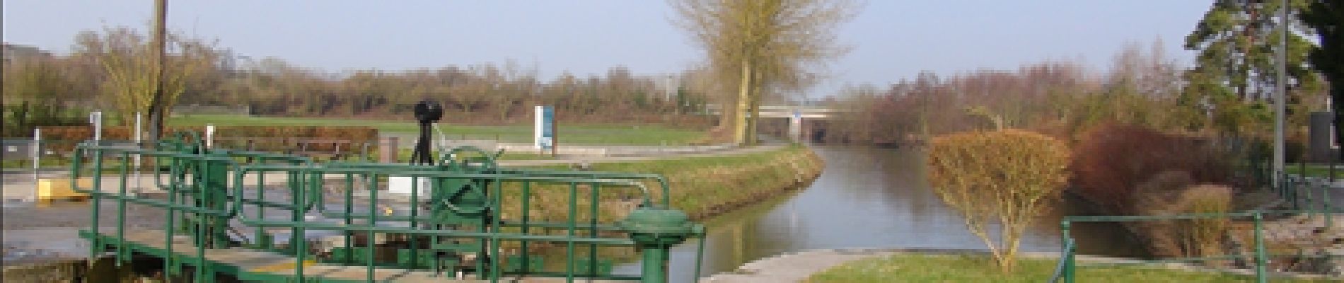
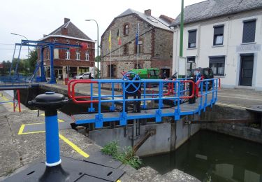
La Thure prend source dans l'entité de Sivry-Rance entre Sautin et Sivry et est rejointe par plusieurs petits affluents avant de quitter la Belgique à Grandrieu. Elle traverse ensuite les villages français d'Hestrud et Cousolre et revient en Belgique par Bersillies-l'Abbaye, avant de se jeter dans la Sambre à Solre-sur-Sambre. Le Château-Fort de Solre-sur-Sambre est l’un des plus anciens châteaux forts du Hainaut qui constitue, par son état exceptionnel de conservation, un témoin remarquable de l’architecture des châteaux forts au Moyen âge.Il est situé dans une plaine en contrebas du village qui était autrefois marécageuse et est entouré de douves alimentées par la rivière « La Thure ».Construit en calcaire, le château fort est une ancienne propriété de la seigneurie de Barbençon de la fin du 13ème au 15ème siècle. ®Départ : église de Solre-sur-Sambre
Localisation
Commentaires
Randonnées à proximité
![Randonnée Marche Merbes-le-Château - RL-GG-05_Labuissière_Landelies - Photo](https://media.geolcdn.com/t/375/260/26645b31-3ae9-4738-a7fa-7de447107697.jpg&format=jpg&maxdim=2)
![Marche Marche](https://static1.geolcdn.com/sitytour/trail-icons/101.png)
Marche
![](/images/other/stat-length.png)
![](https://static1.geolcdn.com/siteimages/upload/files/16400158638029165_repeat_loop_refresh_sync_direction_icon.png)
![Randonnée Marche Merbes-le-Château - RB-Ha-12 - Merbes-le-Château - Photo](https://media.geolcdn.com/t/375/260/ext.jpg?maxdim=2&url=https%3A%2F%2Fservices.sitytrail.com%2FGeolivesWS%2FDownloadMedia.ashx%3FTrailID%3D179606%26Media%3D2e5f16d7-a65c-44ed-9df7-ac0e7837b0d8.jpg)
![Marche Marche](https://static1.geolcdn.com/sitytour/trail-icons/101.png)
Marche
![](/images/other/stat-length.png)
![](https://static1.geolcdn.com/siteimages/upload/files/16400158638029165_repeat_loop_refresh_sync_direction_icon.png)
![Randonnée Marche Merbes-le-Château - De Merbes-le-Château à Labuissière - Photo](https://media.geolcdn.com/t/375/260/ext.jpg?maxdim=2&url=https%3A%2F%2Fservices.sitytrail.com%2FGeolivesWS%2FDownloadMedia.ashx%3FTrailID%3D176232%26Media%3D8745be49-8ccb-4a29-a4e8-e9cc1e458fa8.JPG)
![Marche Marche](https://static1.geolcdn.com/sitytour/trail-icons/101.png)
Marche
![](/images/other/stat-length.png)
![](https://static1.geolcdn.com/siteimages/upload/files/16400158638029165_repeat_loop_refresh_sync_direction_icon.png)
![Randonnée Marche Merbes-le-Château - RB-Ha-12 - Merbes-le-Château - Via raccourci - Photo](https://media.geolcdn.com/t/375/260/ext.jpg?maxdim=2&url=https%3A%2F%2Fservices.sitytrail.com%2FGeolivesWS%2FDownloadMedia.ashx%3FTrailID%3D219496%26Media%3D595f4fee-49cd-407e-b894-79e748aaf4cb.jpg)
![Marche Marche](https://static1.geolcdn.com/sitytour/trail-icons/101.png)
Marche
![](/images/other/stat-length.png)
![](https://static1.geolcdn.com/siteimages/upload/files/16400158638029165_repeat_loop_refresh_sync_direction_icon.png)
![Randonnée Marche Merbes-le-Château - De Labuissiere vers Fontaine-Valmont par la Vallee de la Sambre - Photo](https://media.geolcdn.com/t/375/260/ext.jpg?maxdim=2&url=https%3A%2F%2Fstatic1.geolcdn.com%2Fsiteimages%2Fupload%2Ffiles%2F1553511878bg_sport_marche.png)
![Marche Marche](https://static1.geolcdn.com/sitytour/trail-icons/101.png)
Marche
![](/images/other/stat-length.png)
![](https://static1.geolcdn.com/siteimages/upload/files/16400158638029165_repeat_loop_refresh_sync_direction_icon.png)
![Randonnée Marche nordique Erquelinnes - 6560-05 - Hantes-Wihéries - 9,9km - 104m - Photo](https://media.geolcdn.com/t/375/260/ext.jpg?maxdim=2&url=https%3A%2F%2Fstatic1.geolcdn.com%2Fsiteimages%2Fupload%2Ffiles%2F1545311037marcheuse_200dpi.jpg)
![Marche nordique Marche nordique](https://static1.geolcdn.com/sitytour/trail-icons/102.png)
Marche nordique
![](/images/other/stat-length.png)
![](https://static1.geolcdn.com/siteimages/upload/files/16400158638029165_repeat_loop_refresh_sync_direction_icon.png)
![Randonnée A pied Lobbes - Promenade de Landelin - Photo](https://media.geolcdn.com/t/375/260/ext.jpg?maxdim=2&url=https%3A%2F%2Fpivotmedia.tourismewallonie.be%2FOTH-A0-004A-2DWJ%2FOTH-A0-004A-2DWJ.jpg)
![A pied A pied](https://static1.geolcdn.com/sitytour/trail-icons/100.png)
A pied
![](/images/other/stat-length.png)
![](https://static1.geolcdn.com/siteimages/upload/files/16400158638029165_repeat_loop_refresh_sync_direction_icon.png)
![Randonnée A pied Erquelinnes - Promenade de la Haute Sambre - Photo](https://media.geolcdn.com/t/375/260/ext.jpg?maxdim=2&url=https%3A%2F%2Fpivotmedia.tourismewallonie.be%2FOTH-A0-004D-2OA1%2FOTH-A0-004D-2OA1.jpg)
![A pied A pied](https://static1.geolcdn.com/sitytour/trail-icons/100.png)
A pied
![](/images/other/stat-length.png)
![](https://static1.geolcdn.com/siteimages/upload/files/16400158638029165_repeat_loop_refresh_sync_direction_icon.png)
![Randonnée A pied Erquelinnes - Sur les traces de la frontière hollandaise - Photo](https://media.geolcdn.com/t/375/260/ext.jpg?maxdim=2&url=https%3A%2F%2Fpivotmedia.tourismewallonie.be%2FOTH-A0-004D-2Q2Y%2FOTH-A0-004D-2Q2Y.jpg)
![A pied A pied](https://static1.geolcdn.com/sitytour/trail-icons/100.png)
A pied
![](/images/other/stat-length.png)
![](https://static1.geolcdn.com/siteimages/upload/files/16400158638029165_repeat_loop_refresh_sync_direction_icon.png)
Belle petite balade qui serpente entre les jardins (pas toujours entretenus !), les rives de la Thure et la Sambre.