![](/images/other/stat-length.png)
![Randonnée Marche Guiry-en-Vexin - Guiry en Vexin - Autour du bois de Morval - Photo](https://media.geolcdn.com/t/1900/400/ext.pjpeg?maxdim=2&url=https%3A%2F%2Fstatic1.geolcdn.com%2Fsiteimages%2Fupload%2Ffiles%2F1553511878bg_sport_marche.png)
Guiry en Vexin - Autour du bois de Morval
marcel.F
Utilisateur
![Longueur](/images/other/stat-length.png)
Longueur
9,8 km
![Altitude max](https://static1.geolcdn.com/siteimages/upload/files/1508320355ic_sort_altitude_max_24dp.png)
Altitude max
151 m
![Dénivelé positif](https://static1.geolcdn.com/siteimages/upload/files/1508320355ic_sort_den_pos_24dp.png)
Dénivelé positif
131 m
![Km-Effort](/images/other/stat-length.png)
Km-Effort
11,6 km
![Altitude min](https://static1.geolcdn.com/siteimages/upload/files/1508320355ic_sort_altitude_min_24dp.png)
Altitude min
93 m
![Dénivelé négatif](https://static1.geolcdn.com/siteimages/upload/files/1508320355ic_sort_den_neg_24dp.png)
Dénivelé négatif
131 m
![Boucle](https://static1.geolcdn.com/siteimages/upload/files/16400158638029165_repeat_loop_refresh_sync_direction_icon.png)
Boucle
Oui
Date de création :
2014-12-10 00:00:00.0
Dernière modification :
2014-12-10 00:00:00.0
![Marche](https://static1.geolcdn.com/sitytour/trail-icons/101.png)
2h31
Difficulté : Facile
![Scannez ce code QR pour ouvrir la randonnée dans l'application SityTrail](https://capi.geolives.com/qq0zvz2zws4bq2lad0pu/sitytour/trails/175111/qr.png?size=200)
Application GPS de randonnée GRATUITE
À propos
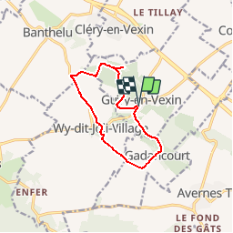
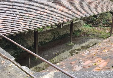
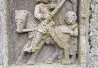
Randonnée Marche de 9,8 km à découvrir à Île-de-France, Val-d'Oise, Guiry-en-Vexin. Cette randonnée est proposée par marcel.F.
Description
Boucle au départ grande rue face au musée archéologique à Guiry en Vexin jusqu'à Allée couverte via Wy-dit-Joli-Village
Localisation
Pays :
France
Région :
Île-de-France
Département/Province :
Val-d'Oise
Commune :
Guiry-en-Vexin
Localité :
Unknown
Départ:(Dec)
Départ:(UTM)
416032 ; 5440119 (31U) N.
Commentaires
Randonnées à proximité
![Randonnée Marche nordique Frémainville - Forêt de Galluis - Photo](https://media.geolcdn.com/t/375/260/ext.jpg?maxdim=2&url=https%3A%2F%2Fservices.sitytrail.com%2FGeolivesWS%2FDownloadMedia.ashx%3FTrailID%3D171555%26Media%3D20130122104829.jpeg)
![Marche nordique Marche nordique](https://static1.geolcdn.com/sitytour/trail-icons/102.png)
Forêt de Galluis
Marche nordique
Facile
(1)
Frémainville,
Île-de-France,
Val-d'Oise,
France
![](/images/other/stat-length.png)
6 km | 7,3 km-effort
1h 20min
![](https://static1.geolcdn.com/siteimages/upload/files/16400158638029165_repeat_loop_refresh_sync_direction_icon.png)
Oui
![Randonnée Marche Arthies - Petite Randonnée des Cinq châteaux - Arthies - Photo](https://media.geolcdn.com/t/375/260/ext.jpg?maxdim=2&url=https%3A%2F%2Fservices.sitytrail.com%2FGeolivesWS%2FDownloadMedia.ashx%3FTrailID%3D101792%26Media%3D2066_5.jpg)
![Marche Marche](https://static1.geolcdn.com/sitytour/trail-icons/101.png)
Petite Randonnée des Cinq châteaux - Arthies
Marche
Moyen
(2)
Arthies,
Île-de-France,
Val-d'Oise,
France
![](/images/other/stat-length.png)
14 km | 17,3 km-effort
3h 0min
![](https://static1.geolcdn.com/siteimages/upload/files/16400158638029165_repeat_loop_refresh_sync_direction_icon.png)
Oui
![Randonnée Marche Frémainville - Fremainville marche 6km - Photo](https://media.geolcdn.com/t/375/260/ext.jpg?maxdim=2&url=https%3A%2F%2Fservices.sitytrail.com%2FGeolivesWS%2FDownloadMedia.ashx%3FTrailID%3D855665%26Media%3Dfix__20171101170303.jpg)
![Marche Marche](https://static1.geolcdn.com/sitytour/trail-icons/101.png)
Fremainville marche 6km
Marche
Moyen
(2)
Frémainville,
Île-de-France,
Val-d'Oise,
France
![](/images/other/stat-length.png)
5,8 km | 7,9 km-effort
1h 20min
![](https://static1.geolcdn.com/siteimages/upload/files/16400158638029165_repeat_loop_refresh_sync_direction_icon.png)
Non
![Randonnée Marche Théméricourt - Théméricourt - La vallée de l''Aubette - Photo](https://media.geolcdn.com/t/375/260/ext.jpg?maxdim=2&url=https%3A%2F%2Fservices.sitytrail.com%2FGeolivesWS%2FDownloadMedia.ashx%3FTrailID%3D158156%26Media%3D9d121a06-3fc5-49da-af2e-21e7dcb3de7b.jpg)
![Marche Marche](https://static1.geolcdn.com/sitytour/trail-icons/101.png)
Théméricourt - La vallée de l''Aubette
Marche
Facile
(1)
Théméricourt,
Île-de-France,
Val-d'Oise,
France
![](/images/other/stat-length.png)
10,4 km | 12,3 km-effort
2h 42min
![](https://static1.geolcdn.com/siteimages/upload/files/16400158638029165_repeat_loop_refresh_sync_direction_icon.png)
Oui
![Randonnée Marche Wy-dit-Joli-Village - Wy dit joli village-Guiry-Gadancourt (boucle) - Photo](https://media.geolcdn.com/t/375/260/ext.jpg?maxdim=2&url=https%3A%2F%2Fstatic1.geolcdn.com%2Fsiteimages%2Fupload%2Ffiles%2F1553511878bg_sport_marche.png)
![Marche Marche](https://static1.geolcdn.com/sitytour/trail-icons/101.png)
Wy dit joli village-Guiry-Gadancourt (boucle)
Marche
Facile
(1)
Wy-dit-Joli-Village,
Île-de-France,
Val-d'Oise,
France
![](/images/other/stat-length.png)
11,1 km | 13,3 km-effort
2h 32min
![](https://static1.geolcdn.com/siteimages/upload/files/16400158638029165_repeat_loop_refresh_sync_direction_icon.png)
Oui
![Randonnée Marche Commeny - Commeny - L'eau et le pain - Photo](https://media.geolcdn.com/t/375/260/ext.jpg?maxdim=2&url=https%3A%2F%2Fstatic1.geolcdn.com%2Fsiteimages%2Fupload%2Ffiles%2F1553511878bg_sport_marche.png)
![Marche Marche](https://static1.geolcdn.com/sitytour/trail-icons/101.png)
Commeny - L'eau et le pain
Marche
Facile
(4)
Commeny,
Île-de-France,
Val-d'Oise,
France
![](/images/other/stat-length.png)
13,2 km | 15,1 km-effort
3h 18min
![](https://static1.geolcdn.com/siteimages/upload/files/16400158638029165_repeat_loop_refresh_sync_direction_icon.png)
Oui
![Randonnée Marche Moussy - Moussy - Photo](https://media.geolcdn.com/t/375/260/f8e793ee-32ac-4817-a085-7f4c279d8d90.jpg&format=jpg&maxdim=2)
![Marche Marche](https://static1.geolcdn.com/sitytour/trail-icons/101.png)
Moussy
Marche
Moyen
(1)
Moussy,
Île-de-France,
Val-d'Oise,
France
![](/images/other/stat-length.png)
8,8 km | 10,2 km-effort
2h 18min
![](https://static1.geolcdn.com/siteimages/upload/files/16400158638029165_repeat_loop_refresh_sync_direction_icon.png)
Oui
![Randonnée Marche Commeny - Kimrny - Photo](https://media.geolcdn.com/t/375/260/a8317e30-56ef-42de-9a93-8f11ddeab597.jpg&format=jpg&maxdim=2)
![Marche Marche](https://static1.geolcdn.com/sitytour/trail-icons/101.png)
Kimrny
Marche
Très facile
Commeny,
Île-de-France,
Val-d'Oise,
France
![](/images/other/stat-length.png)
13,8 km | 15,7 km-effort
3h 21min
![](https://static1.geolcdn.com/siteimages/upload/files/16400158638029165_repeat_loop_refresh_sync_direction_icon.png)
Oui
![Randonnée Marche Guiry-en-Vexin - guiry en wexin - Photo](https://media.geolcdn.com/t/375/260/6830013a-4df6-4179-a88c-c2e9e3b80b3c.jpg&format=jpg&maxdim=2)
![Marche Marche](https://static1.geolcdn.com/sitytour/trail-icons/101.png)
guiry en wexin
Marche
Très facile
Guiry-en-Vexin,
Île-de-France,
Val-d'Oise,
France
![](/images/other/stat-length.png)
9,2 km | 10,9 km-effort
2h 30min
![](https://static1.geolcdn.com/siteimages/upload/files/16400158638029165_repeat_loop_refresh_sync_direction_icon.png)
Oui