Randonnée Marche Soultz-Haut-Rhin - Léo - Photo
 noni
noni

Utilisateur

© OpenStreetMap contributors
Longueur
Longueur
13 km
Altitude max
Altitude max
566 m
Dénivelé positif
Dénivelé positif
476 m
Km-Effort
Km-Effort  
19,4 km
Altitude min
Altitude min
269 m
Dénivelé négatif
Dénivelé négatif
476 m
Boucle
Boucle
Oui
Date de création :
2014-12-10 00:00:00.0
Dernière modification :
2014-12-10 00:00:00.0

(0 Avis)

Marche
Marche
4h09
Difficulté : Inconnu

Scannez ce code QR pour ouvrir la randonnée dans l'application SityTrail

Application GPS de randonnée GRATUITE

Logo SityTrail SityTrail

IGN / Instituts géographiques

Télécharger SityTrail sur l'App Store Télécharger SityTrail sur Google Play

Logo SityTrail SityTrail World

Le monde est à vous

Télécharger SityTrail sur l'App Store Télécharger SityTrail sur Google Play Télécharger SityTrail sur Huawei AppGallery

À propos

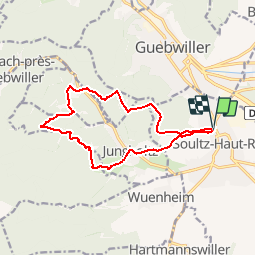
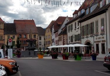
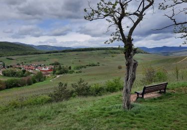
Randonnée Marche de 13 km à découvrir à Grand Est, Haut-Rhin, Soultz-Haut-Rhin. Cette randonnée est proposée par noni.

Description

hopital de soultz
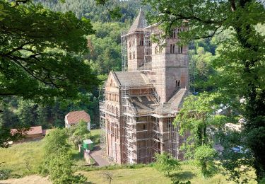
direction Rimbachzell puis thirenbach avec une visite pour revenir sur Soultz

Profil altimétrique

Points d'intérêt

Point d'intérêt Jungholtz - sortie Léo Nouni - Photo
noni

Localisation

Pays :
France
Région :
Grand Est
Département/Province :
Haut-Rhin
Commune :
Soultz-Haut-Rhin
Localité :
Unknown
Départ:(Dec)
Départ:(UTM)
367332 ; 5305653 (32T) N.

Randonnées à proximité

Randonnée V.T.T. Guebwiller - P4  Circuits du Florival 2021   - Photo
V.T.T.
duchaine.nicolas

V.T.T.

Moyen
(1)
Guebwiller, Grand Est, Haut-Rhin, France
40 km | 53 km-effort
4h 31min
Non
Randonnée Marche Murbach - Rando du 01/08/2024 - Photo
Marche
boubou68

Marche

Très difficile
Murbach, Grand Est, Haut-Rhin, France
18,9 km | 30 km-effort
5h 53min
Oui
Randonnée Marche Soultz-Haut-Rhin - Rando Marcheurs..04/04_2025 - Photo
Marche
boubou68

Marche

Très difficile
Soultz-Haut-Rhin, Grand Est, Haut-Rhin, France
21 km | 35 km-effort
4h 42min
Oui
Randonnée Marche Jungholtz - Rando Retrouvailles...01/03/2024.par Jean Marc - Photo
Marche
boubou68

Marche

Très difficile
Jungholtz, Grand Est, Haut-Rhin, France
11,3 km | 19,2 km-effort
1h 35min
Oui
Randonnée Marche Murbach - Murbach - Photo
Marche
oscar1

Marche

Difficile
Murbach, Grand Est, Haut-Rhin, France
15,4 km | 25 km-effort
4h 25min
Oui
Randonnée Vélo de route Issenheim - EXT-65 Issenheim-01 - Photo
Vélo de route
GUIDE
Specialized77

Vélo de route

Facile
Issenheim, Grand Est, Haut-Rhin, France
65 km | 73 km-effort
3h 54min
Oui
Randonnée Marche Orschwihr - Boucle pour Soultzmatt - Photo
Marche
GuyVachet

Marche

Moyen
Orschwihr, Grand Est, Haut-Rhin, France
12,4 km | 16,5 km-effort
4h 4min
Oui
Randonnée Marche Soultz-Haut-Rhin - Wuenheim -  Kohlschlag  (18/03/2021) - Photo
Marche
Richard68500

Marche

Moyen
Soultz-Haut-Rhin, Grand Est, Haut-Rhin, France
15,9 km | 26 km-effort
4h 8min
Oui
Randonnée Marche Buhl - Wolfsgrube (4/3/2021) - Photo
Marche
Richard68500

Marche

Moyen
Buhl, Grand Est, Haut-Rhin, France
12 km | 19 km-effort
3h 39min
Oui


Fermer
Mes abonnements