![](/images/other/stat-length.png)
![Randonnée Marche Étinehem-Méricourt - Le marais de Méricourt sur Somme - Photo](https://media.geolcdn.com/t/1900/400/ext.pjpeg?maxdim=2&url=https%3A%2F%2Fservices.sitytrail.com%2FGeolivesWS%2FDownloadMedia.ashx%3FTrailID%3D173254%26Media%3D14868_2.jpg)
Le marais de Méricourt sur Somme
tracegps
Utilisateur
![Longueur](/images/other/stat-length.png)
![Altitude max](https://static1.geolcdn.com/siteimages/upload/files/1508320355ic_sort_altitude_max_24dp.png)
![Dénivelé positif](https://static1.geolcdn.com/siteimages/upload/files/1508320355ic_sort_den_pos_24dp.png)
![Km-Effort](/images/other/stat-length.png)
![Altitude min](https://static1.geolcdn.com/siteimages/upload/files/1508320355ic_sort_altitude_min_24dp.png)
![Dénivelé négatif](https://static1.geolcdn.com/siteimages/upload/files/1508320355ic_sort_den_neg_24dp.png)
![Boucle](https://static1.geolcdn.com/siteimages/upload/files/16400158638029165_repeat_loop_refresh_sync_direction_icon.png)
![Marche](https://static1.geolcdn.com/sitytour/trail-icons/101.png)
30m
Difficulté : Facile
![Scannez ce code QR pour ouvrir la randonnée dans l'application SityTrail](https://capi.geolives.com/qq0zvz2zws4bq2lad0pu/sitytour/trails/173254/qr.png?size=200)
Application GPS de randonnée GRATUITE
À propos
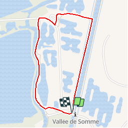
Randonnée Marche de 1,8 km à découvrir à Hauts-de-France, Somme, Étinehem-Méricourt. Cette randonnée est proposée par tracegps.
Description
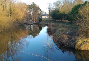
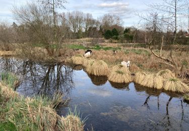
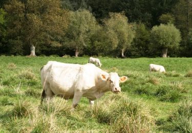
En visitant les marais de Méricourt, la Nature vous livre toutes ses beautés. Randonnée, chasse, pêche et animations de découvertes de la nature... Il y en a pour tous les goûts. Vous pourrez contempler un site magnifique et typique de la vallée de la Somme... Suivez notre guide au cœur de ce marais réhabilité et découvrez un site géré et entretenu par l’homme où la nature reprend peu à peu ses droits. Un lieu entre terre et eau; plongez dans le calme et la verdure d’un espace situé entre terre et eau. Les étangs et les marais sont encerclés à l’Est par le canal de la Somme, et à l’Ouest par la vieille Somme. Les eaux de ce fleuve s’étalent et forment des étangs. Dans ce milieu gorgé d’eau, la faune et la flore s’épanouissent… Téléchargez la fiche du circuit.
Localisation
Commentaires
Randonnées à proximité
![Randonnée Marche Étinehem-Méricourt - Les marais des vaches - Photo](https://media.geolcdn.com/t/375/260/ext.jpg?maxdim=2&url=https%3A%2F%2Fstatic1.geolcdn.com%2Fsiteimages%2Fupload%2Ffiles%2F1553511878bg_sport_marche.png)
![Marche Marche](https://static1.geolcdn.com/sitytour/trail-icons/101.png)
Marche
![](/images/other/stat-length.png)
![](https://static1.geolcdn.com/siteimages/upload/files/16400158638029165_repeat_loop_refresh_sync_direction_icon.png)
![Randonnée Marche Étinehem-Méricourt - les Marais des Vaches - Photo](https://media.geolcdn.com/t/375/260/2665f6d2-4a5d-4afb-8d23-a25653468188.jpg&format=jpg&maxdim=2)
![Marche Marche](https://static1.geolcdn.com/sitytour/trail-icons/101.png)
Marche
![](/images/other/stat-length.png)
![](https://static1.geolcdn.com/siteimages/upload/files/16400158638029165_repeat_loop_refresh_sync_direction_icon.png)
![Randonnée A pied Étinehem-Méricourt - Les Marais de la Violette - Photo](https://media.geolcdn.com/t/375/260/99ec3131-5341-448c-a854-8a5aa8fa62eb.jpeg&format=jpg&maxdim=2)
![A pied A pied](https://static1.geolcdn.com/sitytour/trail-icons/100.png)
A pied
![](/images/other/stat-length.png)
![](https://static1.geolcdn.com/siteimages/upload/files/16400158638029165_repeat_loop_refresh_sync_direction_icon.png)
![Randonnée A pied Cappy - Les Royards - Photo](https://media.geolcdn.com/t/375/260/61c5a7bb-5adb-45c2-89f4-300458b09b65.jpeg&format=jpg&maxdim=2)
![A pied A pied](https://static1.geolcdn.com/sitytour/trail-icons/100.png)
A pied
![](/images/other/stat-length.png)
![](https://static1.geolcdn.com/siteimages/upload/files/16400158638029165_repeat_loop_refresh_sync_direction_icon.png)
![Randonnée Marche Étinehem-Méricourt - le marais des vaches - Photo](https://media.geolcdn.com/t/375/260/240abb99-bbb2-41a8-ac2f-0c05093fc1f4.jpg&format=jpg&maxdim=2)
![Marche Marche](https://static1.geolcdn.com/sitytour/trail-icons/101.png)
Marche
![](/images/other/stat-length.png)
![](https://static1.geolcdn.com/siteimages/upload/files/16400158638029165_repeat_loop_refresh_sync_direction_icon.png)
![Randonnée Marche Chuignolles - CHUIGNOLLES - 80 Circuit du gros canon - Photo](https://media.geolcdn.com/t/375/260/9b9d871f-5b11-44ae-ade1-6d8bca7d07de.jpg&format=jpg&maxdim=2)
![Marche Marche](https://static1.geolcdn.com/sitytour/trail-icons/101.png)
Marche
![](/images/other/stat-length.png)
![](https://static1.geolcdn.com/siteimages/upload/files/16400158638029165_repeat_loop_refresh_sync_direction_icon.png)
![Randonnée Marche Bray-sur-Somme - Bray sur Somme - Photo](https://media.geolcdn.com/t/375/260/72bf1ca5-f920-4b62-805b-e698fd965403.jpg&format=jpg&maxdim=2)
![Marche Marche](https://static1.geolcdn.com/sitytour/trail-icons/101.png)
Marche
![](/images/other/stat-length.png)
![](https://static1.geolcdn.com/siteimages/upload/files/16400158638029165_repeat_loop_refresh_sync_direction_icon.png)
![Randonnée Vélo Bray-sur-Somme - Les Anguillères - Bray sur Somme - Photo](https://media.geolcdn.com/t/375/260/ext.jpg?maxdim=2&url=https%3A%2F%2Fservices.sitytrail.com%2FGeolivesWS%2FDownloadMedia.ashx%3FTrailID%3D109978%26Media%3D5060_1.jpg)
![Vélo Vélo](https://static1.geolcdn.com/sitytour/trail-icons/200.png)
Vélo
![](/images/other/stat-length.png)
![](https://static1.geolcdn.com/siteimages/upload/files/16400158638029165_repeat_loop_refresh_sync_direction_icon.png)
![Randonnée Marche Étinehem-Méricourt - Les marais des vaches - Photo](https://media.geolcdn.com/t/375/260/ext.jpg?maxdim=2&url=https%3A%2F%2Fservices.sitytrail.com%2FGeolivesWS%2FDownloadMedia.ashx%3FTrailID%3D108852%26Media%3D2396_2.jpg)
![Marche Marche](https://static1.geolcdn.com/sitytour/trail-icons/101.png)
Marche
![](/images/other/stat-length.png)
![](https://static1.geolcdn.com/siteimages/upload/files/16400158638029165_repeat_loop_refresh_sync_direction_icon.png)