![](/images/other/stat-length.png)
![Randonnée Marche Abriès-Ristolas - Le Tour du Queyras (Le Roux aux Fonds de Cervières) - Photo](https://media.geolcdn.com/t/1900/400/ext.pjpeg?maxdim=2&url=https%3A%2F%2Fservices.sitytrail.com%2FGeolivesWS%2FDownloadMedia.ashx%3FTrailID%3D173192%26Media%3D14783_5.jpg)
Le Tour du Queyras (Le Roux aux Fonds de Cervières)
tracegps
Utilisateur
![Longueur](/images/other/stat-length.png)
![Altitude max](https://static1.geolcdn.com/siteimages/upload/files/1508320355ic_sort_altitude_max_24dp.png)
![Dénivelé positif](https://static1.geolcdn.com/siteimages/upload/files/1508320355ic_sort_den_pos_24dp.png)
![Km-Effort](/images/other/stat-length.png)
![Altitude min](https://static1.geolcdn.com/siteimages/upload/files/1508320355ic_sort_altitude_min_24dp.png)
![Dénivelé négatif](https://static1.geolcdn.com/siteimages/upload/files/1508320355ic_sort_den_neg_24dp.png)
![Boucle](https://static1.geolcdn.com/siteimages/upload/files/16400158638029165_repeat_loop_refresh_sync_direction_icon.png)
![Marche](https://static1.geolcdn.com/sitytour/trail-icons/101.png)
6h30
Difficulté : Très difficile
![Scannez ce code QR pour ouvrir la randonnée dans l'application SityTrail](https://capi.geolives.com/qq0zvz2zws4bq2lad0pu/sitytour/trails/173192/qr.png?size=200)
Application GPS de randonnée GRATUITE
À propos
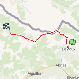
Randonnée Marche de 16,1 km à découvrir à Provence-Alpes-Côte d'Azur, Hautes-Alpes, Abriès-Ristolas. Cette randonnée est proposée par tracegps.
Description
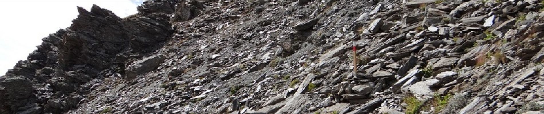
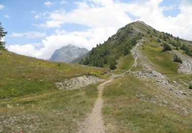
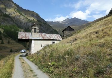
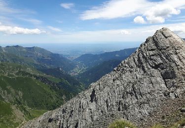
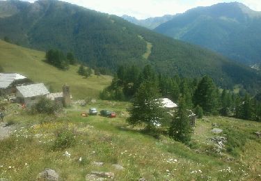
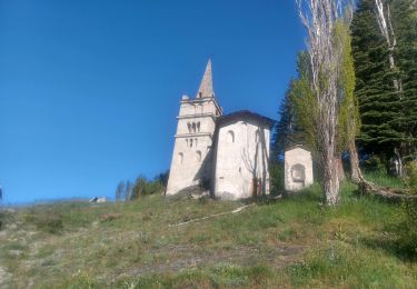
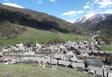
Etape 10: Le GR58D quitte le Roux par le nord sur une piste qui suit le torrent de la Montette jusqu’aux ruines du hameau du même nom détruit par une avalanche. Au niveau de la chapelle qui a été restaurée on bifurque vers l’ouest-nord-ouest et les choses sérieuses commencent : 875 mètres de pente très raide jusqu’au col des Thures. Mais le paysage grandiose parvient à atténuer la difficulté. Au col on souffle un peu, on remet les coupe-vent et on fait une petite incursion en Italie pour rejoindre le col de Rasis.Après avoir longé un lac sans nom, on entame une descente dans la caillasse qui, sans être très compliquée demande un minimum d’attention. Dans la grande traversée qui suit, le sentier n’est pas trop compliqué à parcourir à condition de ne pas le perdre, ce qui est assez facile : je sais que ce n’est pas évident dans ces endroits reculés, mais le balisage mériterait un petit rafraîchissement. Si, comme les deux randonneurs qui nous précédaient vous vous laissez aller un peu trop bas vers la Sagne Michel, vous risquez, comme eux, d’en baver pour rattraper le sentier… Une fois arrivé au col de Malrif vous poursuivez en crête jusqu’au pic du même métal où vous profitez de la vue à 360° sur les Alpes du Sud. Vous pouvez aussi prendre un en-cas car la descente vers les Fonts de Cervières est assez longue. Il faut d’abord rejoindre, au petit col en contrebas (cote 2830), le GR58 qui vient d’Abriès en passant par les lacs du Malrif ; une jolie bavante, heu je voulais dire balade, aussi, mais c’est une autre histoire ;-). Ensuite il n’y a plus qu’à se laisser aller le long du torrent de Pierre Rouge jusqu’aux Fonds. En passant vous pouvez discuter avec le très sympathique berger de l’énorme troupeau qui habite ici en été. Il ne vous reste plus qu’à espérer que le gratin dauphinois est au menu du gîte ce soir : il est à tomber par terre !
Localisation
Commentaires
Randonnées à proximité
![Randonnée Marche Abriès-Ristolas - collette et crête de Gilly - Photo](https://media.geolcdn.com/t/375/260/ext.jpg?maxdim=2&url=https%3A%2F%2Fservices.sitytrail.com%2FGeolivesWS%2FDownloadMedia.ashx%3FTrailID%3D446478%26Media%3D5a2314a0-5704-407c-911d-1beb50f4e518.JPG)
![Marche Marche](https://static1.geolcdn.com/sitytour/trail-icons/101.png)
Marche
![](/images/other/stat-length.png)
![](https://static1.geolcdn.com/siteimages/upload/files/16400158638029165_repeat_loop_refresh_sync_direction_icon.png)
![Randonnée Marche Abriès-Ristolas - le Bric Froid - Photo](https://media.geolcdn.com/t/375/260/ext.jpg?maxdim=2&url=https%3A%2F%2Fservices.sitytrail.com%2FGeolivesWS%2FDownloadMedia.ashx%3FTrailID%3D818905%26Media%3Dfix__20170828120643.jpg)
![Marche Marche](https://static1.geolcdn.com/sitytour/trail-icons/101.png)
Marche
![](/images/other/stat-length.png)
![](https://static1.geolcdn.com/siteimages/upload/files/16400158638029165_repeat_loop_refresh_sync_direction_icon.png)
![Randonnée Marche Abriès-Ristolas - Abriès - Aiguilles - Photo](https://media.geolcdn.com/t/375/260/ext.jpg?maxdim=2&url=https%3A%2F%2Fservices.sitytrail.com%2FGeolivesWS%2FDownloadMedia.ashx%3FTrailID%3D629859%26Media%3Dfix__20160907131116.jpg)
![Marche Marche](https://static1.geolcdn.com/sitytour/trail-icons/101.png)
Marche
![](/images/other/stat-length.png)
![](https://static1.geolcdn.com/siteimages/upload/files/16400158638029165_repeat_loop_refresh_sync_direction_icon.png)
![Randonnée Marche Abriès-Ristolas - Abriès - Aiguilles - Photo](https://media.geolcdn.com/t/375/260/ext.jpg?maxdim=2&url=https%3A%2F%2Fservices.sitytrail.com%2FGeolivesWS%2FDownloadMedia.ashx%3FTrailID%3D629858%26Media%3Dfix__20160907131116.jpg)
![Marche Marche](https://static1.geolcdn.com/sitytour/trail-icons/101.png)
Marche
![](/images/other/stat-length.png)
![](https://static1.geolcdn.com/siteimages/upload/files/16400158638029165_repeat_loop_refresh_sync_direction_icon.png)
![Randonnée Marche Abriès-Ristolas - col d'Urine et Maït d'Amunt - Photo](https://media.geolcdn.com/t/375/260/ext.jpg?maxdim=2&url=https%3A%2F%2Fservices.sitytrail.com%2FGeolivesWS%2FDownloadMedia.ashx%3FTrailID%3D598105%26Media%3Dfix__20160714125309.jpg)
![Marche Marche](https://static1.geolcdn.com/sitytour/trail-icons/101.png)
Marche
![](/images/other/stat-length.png)
![](https://static1.geolcdn.com/siteimages/upload/files/16400158638029165_repeat_loop_refresh_sync_direction_icon.png)
![Randonnée Marche Abriès-Ristolas - Pré Roubaud - Photo](https://media.geolcdn.com/t/375/260/ext.jpg?maxdim=2&url=https%3A%2F%2Fservices.sitytrail.com%2FGeolivesWS%2FDownloadMedia.ashx%3FTrailID%3D330533%26Media%3Dfix__20140803155129.jpg)
![Marche Marche](https://static1.geolcdn.com/sitytour/trail-icons/101.png)
Marche
![](/images/other/stat-length.png)
![](https://static1.geolcdn.com/siteimages/upload/files/16400158638029165_repeat_loop_refresh_sync_direction_icon.png)
![Randonnée Marche Abriès-Ristolas - Le Bois Noir - Photo](https://media.geolcdn.com/t/375/260/ext.jpg?maxdim=2&url=https%3A%2F%2Fstatic1.geolcdn.com%2Fsiteimages%2Fupload%2Ffiles%2F1553511878bg_sport_marche.png)
![Marche Marche](https://static1.geolcdn.com/sitytour/trail-icons/101.png)
Marche
![](/images/other/stat-length.png)
![](https://static1.geolcdn.com/siteimages/upload/files/16400158638029165_repeat_loop_refresh_sync_direction_icon.png)
![Randonnée Marche Abriès-Ristolas - ABRIES - Photo](https://media.geolcdn.com/t/375/260/95105ed2-aa76-467e-a649-7d2ce80aa1e2.jpg&format=jpg&maxdim=2)
![Marche Marche](https://static1.geolcdn.com/sitytour/trail-icons/101.png)
Marche
![](/images/other/stat-length.png)
![](https://static1.geolcdn.com/siteimages/upload/files/16400158638029165_repeat_loop_refresh_sync_direction_icon.png)
![Randonnée Marche Abriès-Ristolas - Malrif à partir de Abries - Photo](https://media.geolcdn.com/t/375/260/2962a407-1b8d-4c1a-aa47-69b94a8a67a9.jpg&format=jpg&maxdim=2)
![Marche Marche](https://static1.geolcdn.com/sitytour/trail-icons/101.png)
Marche
![](/images/other/stat-length.png)
![](https://static1.geolcdn.com/siteimages/upload/files/16400158638029165_repeat_loop_refresh_sync_direction_icon.png)