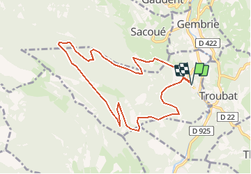
![](/images/other/stat-length.png)
![Randonnée Marche Bramevaque - Sous le Mont Sacon - Bramevaque - Photo](https://media.geolcdn.com/t/1900/400/ext.pjpeg?maxdim=2&url=https%3A%2F%2Fservices.sitytrail.com%2FGeolivesWS%2FDownloadMedia.ashx%3FTrailID%3D172959%26Media%3D14442_2.jpg)
Sous le Mont Sacon - Bramevaque
tracegps
Utilisateur
![Longueur](/images/other/stat-length.png)
![Altitude max](https://static1.geolcdn.com/siteimages/upload/files/1508320355ic_sort_altitude_max_24dp.png)
![Dénivelé positif](https://static1.geolcdn.com/siteimages/upload/files/1508320355ic_sort_den_pos_24dp.png)
![Km-Effort](/images/other/stat-length.png)
![Altitude min](https://static1.geolcdn.com/siteimages/upload/files/1508320355ic_sort_altitude_min_24dp.png)
![Dénivelé négatif](https://static1.geolcdn.com/siteimages/upload/files/1508320355ic_sort_den_neg_24dp.png)
![Boucle](https://static1.geolcdn.com/siteimages/upload/files/16400158638029165_repeat_loop_refresh_sync_direction_icon.png)
![Marche](https://static1.geolcdn.com/sitytour/trail-icons/101.png)
2h30
Difficulté : Moyen
![Scannez ce code QR pour ouvrir la randonnée dans l'application SityTrail](https://capi.geolives.com/qq0zvz2zws4bq2lad0pu/sitytour/trails/172959/qr.png?size=200)
Application GPS de randonnée GRATUITE
À propos
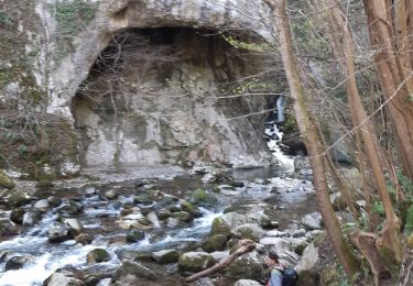
Randonnée Marche de 9,9 km à découvrir à Occitanie, Hautes-Pyrénées, Bramevaque. Cette randonnée est proposée par tracegps.
Description
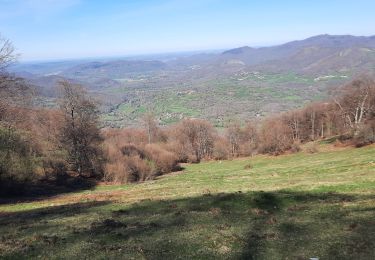
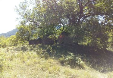
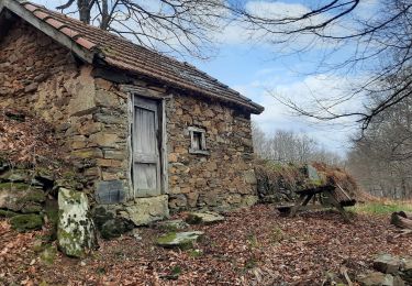
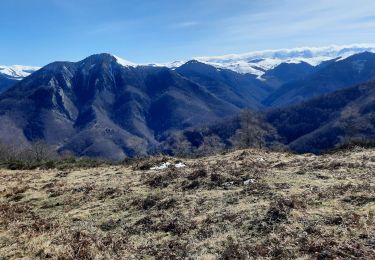
Joli circuit de basse montagne (sous les 1300m) mais très agréable. Il permet de faire une bonne initiation au trail (course à pied en montagne), avec plusieurs variantes permettant d'aller jusqu'au sommet (1450m) si la condition physique et la météo sont au rendez-vous. Faire attention en automne car c'est une zone de chasse fréquentée mais partagée sans contrainte!
Localisation
Commentaires
Randonnées à proximité
![Randonnée Marche Antichan - sommet d'Herbe Rouge en boucle depuis Antichan - Photo](https://media.geolcdn.com/t/375/260/2676d141-2d54-4591-a0ca-fc3fcbbbc6ad.jpg&format=jpg&maxdim=2)
![Marche Marche](https://static1.geolcdn.com/sitytour/trail-icons/101.png)
Marche
![](/images/other/stat-length.png)
![](https://static1.geolcdn.com/siteimages/upload/files/16400158638029165_repeat_loop_refresh_sync_direction_icon.png)
![Marche Marche](https://static1.geolcdn.com/sitytour/trail-icons/101.png)
Marche
![](/images/other/stat-length.png)
![](https://static1.geolcdn.com/siteimages/upload/files/16400158638029165_repeat_loop_refresh_sync_direction_icon.png)
![Randonnée Marche Mauléon-Barousse - MAULEON BAROUSSE la rando de Payremilla (G3) faite le 23/10/2020 - Photo](https://media.geolcdn.com/t/375/260/f54aedb7-7843-4cd9-8363-8502c158108a.jpg&format=jpg&maxdim=2)
![Marche Marche](https://static1.geolcdn.com/sitytour/trail-icons/101.png)
Marche
![](/images/other/stat-length.png)
![](https://static1.geolcdn.com/siteimages/upload/files/16400158638029165_repeat_loop_refresh_sync_direction_icon.png)
![Randonnée Marche Bramevaque - randonnée sur le Touroc depuis Bramevaque - Photo](https://media.geolcdn.com/t/375/260/11044ee2-ac3e-40d6-87ed-897d2a6f400f.jpg&format=jpg&maxdim=2)
![Marche Marche](https://static1.geolcdn.com/sitytour/trail-icons/101.png)
Marche
![](/images/other/stat-length.png)
![](https://static1.geolcdn.com/siteimages/upload/files/16400158638029165_repeat_loop_refresh_sync_direction_icon.png)
![Randonnée Marche Mauléon-Barousse - MAULEON BAROUSSE Circuit des amis du Lac](https://media.geolcdn.com/t/375/260/514ad499-f66e-4243-b144-7abeb20a1a25.jpg&format=jpg&maxdim=2)
![Marche Marche](https://static1.geolcdn.com/sitytour/trail-icons/101.png)
Marche
![](/images/other/stat-length.png)
![](https://static1.geolcdn.com/siteimages/upload/files/16400158638029165_repeat_loop_refresh_sync_direction_icon.png)
![Randonnée Marche Ferrère - pic de Douly en boucle depuis Ferrère - Photo](https://media.geolcdn.com/t/375/260/c7147a1a-6f87-4c7b-aaa1-5f3c152be715.jpg&format=jpg&maxdim=2)
![Marche Marche](https://static1.geolcdn.com/sitytour/trail-icons/101.png)
Marche
![](/images/other/stat-length.png)
![](https://static1.geolcdn.com/siteimages/upload/files/16400158638029165_repeat_loop_refresh_sync_direction_icon.png)
![Randonnée Marche Sacoué - marrouye depuis le pied du Touroc - Photo](https://media.geolcdn.com/t/375/260/0ada9eb7-2f86-4640-922c-3c6782533cb1.jpg&format=jpg&maxdim=2)
![Marche Marche](https://static1.geolcdn.com/sitytour/trail-icons/101.png)
Marche
![](/images/other/stat-length.png)
![](https://static1.geolcdn.com/siteimages/upload/files/16400158638029165_repeat_loop_refresh_sync_direction_icon.png)
![Randonnée Marche Mauléon-Barousse - MauleonB G3 - Photo](https://media.geolcdn.com/t/375/260/c6a44a1e-be52-4b9c-a0d4-31ef4d7cae02.jpg&format=jpg&maxdim=2)
![Marche Marche](https://static1.geolcdn.com/sitytour/trail-icons/101.png)
Marche
![](/images/other/stat-length.png)
![](https://static1.geolcdn.com/siteimages/upload/files/16400158638029165_repeat_loop_refresh_sync_direction_icon.png)
![Randonnée A pied Mauléon-Barousse - Mauleon Barousse-Esbareich-Ourde - Photo](https://media.geolcdn.com/t/375/260/ext.jpg?maxdim=2&url=https%3A%2F%2Fstatic1.geolcdn.com%2Fsiteimages%2Fupload%2Ffiles%2F1545311037marcheuse_200dpi.jpg)
![A pied A pied](https://static1.geolcdn.com/sitytour/trail-icons/100.png)
A pied
![](/images/other/stat-length.png)
![](https://static1.geolcdn.com/siteimages/upload/files/16400158638029165_repeat_loop_refresh_sync_direction_icon.png)