![](/images/other/stat-length.png)
![Randonnée Marche Chandai - Les Masselins - Chandai - Photo](https://media.geolcdn.com/t/1900/400/ext.pjpeg?maxdim=2&url=https%3A%2F%2Fservices.sitytrail.com%2FGeolivesWS%2FDownloadMedia.ashx%3FTrailID%3D172956%26Media%3D14436_2.jpg)
Les Masselins - Chandai
tracegps
Utilisateur
![Longueur](/images/other/stat-length.png)
Longueur
6,5 km
![Altitude max](https://static1.geolcdn.com/siteimages/upload/files/1508320355ic_sort_altitude_max_24dp.png)
Altitude max
218 m
![Dénivelé positif](https://static1.geolcdn.com/siteimages/upload/files/1508320355ic_sort_den_pos_24dp.png)
Dénivelé positif
63 m
![Km-Effort](/images/other/stat-length.png)
Km-Effort
7,4 km
![Altitude min](https://static1.geolcdn.com/siteimages/upload/files/1508320355ic_sort_altitude_min_24dp.png)
Altitude min
189 m
![Dénivelé négatif](https://static1.geolcdn.com/siteimages/upload/files/1508320355ic_sort_den_neg_24dp.png)
Dénivelé négatif
62 m
![Boucle](https://static1.geolcdn.com/siteimages/upload/files/16400158638029165_repeat_loop_refresh_sync_direction_icon.png)
Boucle
Oui
Date de création :
2014-12-10 00:00:00.0
Dernière modification :
2014-12-10 00:00:00.0
![Marche](https://static1.geolcdn.com/sitytour/trail-icons/101.png)
1h34
Difficulté : Facile
![Scannez ce code QR pour ouvrir la randonnée dans l'application SityTrail](https://capi.geolives.com/qq0zvz2zws4bq2lad0pu/sitytour/trails/172956/qr.png?size=200)
Application GPS de randonnée GRATUITE
À propos
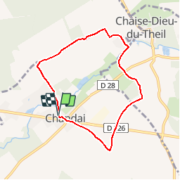
Randonnée Marche de 6,5 km à découvrir à Normandie, Orne, Chandai. Cette randonnée est proposée par tracegps.
Description
Départ du parking de l’église de Chandai. Ce circuit fait partie des fiches de randonnées du Pays d’Ouche diffusées par l’office du tourisme de l’Aigle. Retrouvez le plan et le descriptif sur le site de la Commune de Chandai.
Localisation
Pays :
France
Région :
Normandie
Département/Province :
Orne
Commune :
Chandai
Localité :
Unknown
Départ:(Dec)
Départ:(UTM)
333785 ; 5402571 (31U) N.
Commentaires
Randonnées à proximité
![Randonnée V.T.T. Saint-Martin-d'Écublei - VTT_Nd et Ouest Biéville-Beuville - Photo](https://media.geolcdn.com/t/375/260/ext.jpg?maxdim=2&url=https%3A%2F%2Fstatic1.geolcdn.com%2Fsiteimages%2Fupload%2Ffiles%2F1524743154velo.jpg)
![V.T.T. V.T.T.](https://static1.geolcdn.com/sitytour/trail-icons/202.png)
VTT_Nd et Ouest Biéville-Beuville
V.T.T.
Très difficile
Saint-Martin-d'Écublei,
Normandie,
Orne,
France
![](/images/other/stat-length.png)
103 km | 114 km-effort
7h 53min
![](https://static1.geolcdn.com/siteimages/upload/files/16400158638029165_repeat_loop_refresh_sync_direction_icon.png)
Oui
![Randonnée Marche Chaise-Dieu-du-Theil - chaise dieu du theil 27 mars - Photo](https://media.geolcdn.com/t/375/260/ext.jpg?maxdim=2&url=https%3A%2F%2Fstatic1.geolcdn.com%2Fsiteimages%2Fupload%2Ffiles%2F1553511878bg_sport_marche.png)
![Marche Marche](https://static1.geolcdn.com/sitytour/trail-icons/101.png)
chaise dieu du theil 27 mars
Marche
Facile
Chaise-Dieu-du-Theil,
Normandie,
Eure,
France
![](/images/other/stat-length.png)
8,5 km | 9,6 km-effort
2h 8min
![](https://static1.geolcdn.com/siteimages/upload/files/16400158638029165_repeat_loop_refresh_sync_direction_icon.png)
Oui
![Randonnée Marche Chandai - chandai, ,chaise Dieu du Thiel, les masselins - Photo](https://media.geolcdn.com/t/375/260/ext.jpg?maxdim=2&url=https%3A%2F%2Fstatic1.geolcdn.com%2Fsiteimages%2Fupload%2Ffiles%2F1553511878bg_sport_marche.png)
![Marche Marche](https://static1.geolcdn.com/sitytour/trail-icons/101.png)
chandai, ,chaise Dieu du Thiel, les masselins
Marche
Moyen
Chandai,
Normandie,
Orne,
France
![](/images/other/stat-length.png)
7,4 km | 8,1 km-effort
2h 8min
![](https://static1.geolcdn.com/siteimages/upload/files/16400158638029165_repeat_loop_refresh_sync_direction_icon.png)
Oui
![Randonnée Marche Bourth - Bourth - Photo](https://media.geolcdn.com/t/375/260/ext.jpg?maxdim=2&url=https%3A%2F%2Fstatic1.geolcdn.com%2Fsiteimages%2Fupload%2Ffiles%2F1553511878bg_sport_marche.png)
![Marche Marche](https://static1.geolcdn.com/sitytour/trail-icons/101.png)
![Randonnée Marche Saint-Martin-d'Écublei - Saint Martin d'Ecublei - Photo](https://media.geolcdn.com/t/375/260/ext.jpg?maxdim=2&url=https%3A%2F%2Fstatic1.geolcdn.com%2Fsiteimages%2Fupload%2Ffiles%2F1553511878bg_sport_marche.png)
![Marche Marche](https://static1.geolcdn.com/sitytour/trail-icons/101.png)
Saint Martin d'Ecublei
Marche
Moyen
Saint-Martin-d'Écublei,
Normandie,
Orne,
France
![](/images/other/stat-length.png)
8,8 km | 10 km-effort
2h 21min
![](https://static1.geolcdn.com/siteimages/upload/files/16400158638029165_repeat_loop_refresh_sync_direction_icon.png)
Oui
![Randonnée A pied Saint-Martin-d'Écublei - Saint Martin D'Ecublei- Vieille Chaise Dieu - Photo](https://media.geolcdn.com/t/375/260/ext.jpg?maxdim=2&url=https%3A%2F%2Fstatic1.geolcdn.com%2Fsiteimages%2Fupload%2Ffiles%2F1545311037marcheuse_200dpi.jpg)
![A pied A pied](https://static1.geolcdn.com/sitytour/trail-icons/100.png)
Saint Martin D'Ecublei- Vieille Chaise Dieu
A pied
Facile
Saint-Martin-d'Écublei,
Normandie,
Orne,
France
![](/images/other/stat-length.png)
8,5 km | 9,7 km-effort
2h 12min
![](https://static1.geolcdn.com/siteimages/upload/files/16400158638029165_repeat_loop_refresh_sync_direction_icon.png)
Oui
![Randonnée Marche Chaise-Dieu-du-Theil - Chaise Dieu du Theil - Photo](https://media.geolcdn.com/t/375/260/ext.jpg?maxdim=2&url=https%3A%2F%2Fstatic1.geolcdn.com%2Fsiteimages%2Fupload%2Ffiles%2F1553511878bg_sport_marche.png)
![Marche Marche](https://static1.geolcdn.com/sitytour/trail-icons/101.png)
Chaise Dieu du Theil
Marche
Facile
Chaise-Dieu-du-Theil,
Normandie,
Eure,
France
![](/images/other/stat-length.png)
8,5 km | 9,3 km-effort
2h 7min
![](https://static1.geolcdn.com/siteimages/upload/files/16400158638029165_repeat_loop_refresh_sync_direction_icon.png)
Oui
![Randonnée Marche Saint-Ouen-sur-Iton - Saint Ouen sur Iton - Photo](https://media.geolcdn.com/t/375/260/ext.jpg?maxdim=2&url=https%3A%2F%2Fstatic1.geolcdn.com%2Fsiteimages%2Fupload%2Ffiles%2F1553511878bg_sport_marche.png)
![Marche Marche](https://static1.geolcdn.com/sitytour/trail-icons/101.png)
Saint Ouen sur Iton
Marche
Moyen
Saint-Ouen-sur-Iton,
Normandie,
Orne,
France
![](/images/other/stat-length.png)
8,3 km | 9,1 km-effort
1h 51min
![](https://static1.geolcdn.com/siteimages/upload/files/16400158638029165_repeat_loop_refresh_sync_direction_icon.png)
Oui
![Randonnée Marche Saint-Ouen-sur-Iton - St Ouen sur Iton 17.38 - Photo](https://media.geolcdn.com/t/375/260/ext.jpg?maxdim=2&url=https%3A%2F%2Fstatic1.geolcdn.com%2Fsiteimages%2Fupload%2Ffiles%2F1553511878bg_sport_marche.png)
![Marche Marche](https://static1.geolcdn.com/sitytour/trail-icons/101.png)
St Ouen sur Iton 17.38
Marche
Moyen
Saint-Ouen-sur-Iton,
Normandie,
Orne,
France
![](/images/other/stat-length.png)
17,4 km | 19 km-effort
4h 7min
![](https://static1.geolcdn.com/siteimages/upload/files/16400158638029165_repeat_loop_refresh_sync_direction_icon.png)
Oui