![](/images/other/stat-length.png)
![Randonnée Cheval Saint-Paulien - Des Pradeaux à St André de Chalencon à cheval - Photo](https://media.geolcdn.com/t/1900/400/ext.pjpeg?maxdim=2&url=https%3A%2F%2Fservices.sitytrail.com%2FGeolivesWS%2FDownloadMedia.ashx%3FTrailID%3D172932%26Media%3D14407_2.jpg)
Des Pradeaux à St André de Chalencon à cheval
tracegps
Utilisateur
![Longueur](/images/other/stat-length.png)
Longueur
35 km
![Altitude max](https://static1.geolcdn.com/siteimages/upload/files/1508320355ic_sort_altitude_max_24dp.png)
Altitude max
977 m
![Dénivelé positif](https://static1.geolcdn.com/siteimages/upload/files/1508320355ic_sort_den_pos_24dp.png)
Dénivelé positif
860 m
![Km-Effort](/images/other/stat-length.png)
Km-Effort
46 km
![Altitude min](https://static1.geolcdn.com/siteimages/upload/files/1508320355ic_sort_altitude_min_24dp.png)
Altitude min
530 m
![Dénivelé négatif](https://static1.geolcdn.com/siteimages/upload/files/1508320355ic_sort_den_neg_24dp.png)
Dénivelé négatif
877 m
![Boucle](https://static1.geolcdn.com/siteimages/upload/files/16400158638029165_repeat_loop_refresh_sync_direction_icon.png)
Boucle
Non
Date de création :
2014-12-10 00:00:00.0
Dernière modification :
2014-12-10 00:00:00.0
![Cheval](https://static1.geolcdn.com/sitytour/trail-icons/300.png)
6h55
Difficulté : Moyen
![Scannez ce code QR pour ouvrir la randonnée dans l'application SityTrail](https://capi.geolives.com/qq0zvz2zws4bq2lad0pu/sitytour/trails/172932/qr.png?size=200)
Application GPS de randonnée GRATUITE
À propos
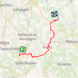
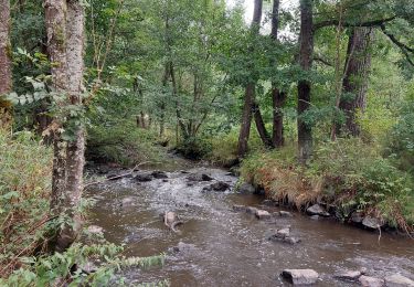
Randonnée Cheval de 35 km à découvrir à Auvergne-Rhône-Alpes, Haute-Loire, Saint-Paulien. Cette randonnée est proposée par tracegps.
Description
Départ du gite Equestre des Pradeaux près d'Anazac. Un bon dénivelé en descendant sur Vorey de 972 m à 539 m puis remonter ensuite à 944 m. Super accueil pour les cavaliers au Château de Chazelles.
Localisation
Pays :
France
Région :
Auvergne-Rhône-Alpes
Département/Province :
Haute-Loire
Commune :
Saint-Paulien
Localité :
Unknown
Départ:(Dec)
Départ:(UTM)
561500 ; 5000816 (31T) N.
Commentaires
Randonnées à proximité
![Randonnée Marche Saint-Paulien - St Paulien - LISSAC - Photo](https://media.geolcdn.com/t/375/260/ed7035c4-df10-46ce-ae71-77e06c24182f.jpg&format=jpg&maxdim=2)
![Marche Marche](https://static1.geolcdn.com/sitytour/trail-icons/101.png)
St Paulien - LISSAC
Marche
Facile
Saint-Paulien,
Auvergne-Rhône-Alpes,
Haute-Loire,
France
![](/images/other/stat-length.png)
6,2 km | 7,4 km-effort
1h 29min
![](https://static1.geolcdn.com/siteimages/upload/files/16400158638029165_repeat_loop_refresh_sync_direction_icon.png)
Non
![Randonnée Cheval Saint-Paulien - Autour d'Allègre - Photo](https://media.geolcdn.com/t/375/260/ext.jpg?maxdim=2&url=https%3A%2F%2Fservices.sitytrail.com%2FGeolivesWS%2FDownloadMedia.ashx%3FTrailID%3D106951%26Media%3D11716_6.jpg)
![Cheval Cheval](https://static1.geolcdn.com/sitytour/trail-icons/300.png)
Autour d'Allègre
Cheval
Moyen
Saint-Paulien,
Auvergne-Rhône-Alpes,
Haute-Loire,
France
![](/images/other/stat-length.png)
24 km | 32 km-effort
6h 10min
![](https://static1.geolcdn.com/siteimages/upload/files/16400158638029165_repeat_loop_refresh_sync_direction_icon.png)
Oui
![Randonnée Marche Saint-Geneys-près-Saint-Paulien - Col de la croix de l'Alrbre - Photo](https://media.geolcdn.com/t/375/260/5fc6bcef-e958-4ce3-acc7-dded830ba656.jpg&format=jpg&maxdim=2)
![Marche Marche](https://static1.geolcdn.com/sitytour/trail-icons/101.png)
Col de la croix de l'Alrbre
Marche
Facile
Saint-Geneys-près-Saint-Paulien,
Auvergne-Rhône-Alpes,
Haute-Loire,
France
![](/images/other/stat-length.png)
5,1 km | 7,8 km-effort
1h 42min
![](https://static1.geolcdn.com/siteimages/upload/files/16400158638029165_repeat_loop_refresh_sync_direction_icon.png)
Oui
![Randonnée Marche Saint-Paulien - Autours du château de la Rochelambert - Photo](https://media.geolcdn.com/t/375/260/f04c4d73-3dcd-4bb0-9a6f-6d111c3c3c21.jpg&format=jpg&maxdim=2)
![Marche Marche](https://static1.geolcdn.com/sitytour/trail-icons/101.png)
Autours du château de la Rochelambert
Marche
Moyen
Saint-Paulien,
Auvergne-Rhône-Alpes,
Haute-Loire,
France
![](/images/other/stat-length.png)
5,9 km | 7,2 km-effort
2h 37min
![](https://static1.geolcdn.com/siteimages/upload/files/16400158638029165_repeat_loop_refresh_sync_direction_icon.png)
Oui
![Randonnée Marche Céaux-d'Allègre - GR 40_9 - Photo](https://media.geolcdn.com/t/375/260/ext.jpg?maxdim=2&url=https%3A%2F%2Fstatic1.geolcdn.com%2Fsiteimages%2Fupload%2Ffiles%2F1553511878bg_sport_marche.png)
![Marche Marche](https://static1.geolcdn.com/sitytour/trail-icons/101.png)
GR 40_9
Marche
Moyen
Céaux-d'Allègre,
Auvergne-Rhône-Alpes,
Haute-Loire,
France
![](/images/other/stat-length.png)
20 km | 28 km-effort
7h 40min
![](https://static1.geolcdn.com/siteimages/upload/files/16400158638029165_repeat_loop_refresh_sync_direction_icon.png)
Non
![Randonnée Marche Saint-Geneys-près-Saint-Paulien - PR347 - Photo](https://media.geolcdn.com/t/375/260/ext.jpg?maxdim=2&url=https%3A%2F%2Fstatic1.geolcdn.com%2Fsiteimages%2Fupload%2Ffiles%2F1553511878bg_sport_marche.png)
![Marche Marche](https://static1.geolcdn.com/sitytour/trail-icons/101.png)
PR347
Marche
Facile
Saint-Geneys-près-Saint-Paulien,
Auvergne-Rhône-Alpes,
Haute-Loire,
France
![](/images/other/stat-length.png)
11 km | 13,4 km-effort
3h 0min
![](https://static1.geolcdn.com/siteimages/upload/files/16400158638029165_repeat_loop_refresh_sync_direction_icon.png)
Non
![Randonnée Randonnée équestre Saint-Paulien - premier jour 36 kms rando des écrins vert - Photo](https://media.geolcdn.com/t/375/260/ext.jpg?maxdim=2&url=https%3A%2F%2Fstatic1.geolcdn.com%2Fsiteimages%2Fupload%2Ffiles%2F1524743154cheval.jpg)
![Randonnée équestre Randonnée équestre](https://static1.geolcdn.com/sitytour/trail-icons/301.png)
premier jour 36 kms rando des écrins vert
Randonnée équestre
Très difficile
Saint-Paulien,
Auvergne-Rhône-Alpes,
Haute-Loire,
France
![](/images/other/stat-length.png)
36 km | 47 km-effort
5h 50min
![](https://static1.geolcdn.com/siteimages/upload/files/16400158638029165_repeat_loop_refresh_sync_direction_icon.png)
Non
![Randonnée Randonnée équestre Saint-Paulien - Altiligérienne - Photo](https://media.geolcdn.com/t/375/260/ext.jpg?maxdim=2&url=https%3A%2F%2Fstatic1.geolcdn.com%2Fsiteimages%2Fupload%2Ffiles%2F1524743154cheval.jpg)
![Randonnée équestre Randonnée équestre](https://static1.geolcdn.com/sitytour/trail-icons/301.png)
Altiligérienne
Randonnée équestre
Très difficile
Saint-Paulien,
Auvergne-Rhône-Alpes,
Haute-Loire,
France
![](/images/other/stat-length.png)
176 km | 231 km-effort
28h 26min
![](https://static1.geolcdn.com/siteimages/upload/files/16400158638029165_repeat_loop_refresh_sync_direction_icon.png)
Oui
![Randonnée Marche Saint-Paulien - St Paulien - Photo](https://media.geolcdn.com/t/375/260/ext.jpg?maxdim=2&url=https%3A%2F%2Fstatic1.geolcdn.com%2Fsiteimages%2Fupload%2Ffiles%2F1553511878bg_sport_marche.png)
![Marche Marche](https://static1.geolcdn.com/sitytour/trail-icons/101.png)
St Paulien
Marche
Facile
(2)
Saint-Paulien,
Auvergne-Rhône-Alpes,
Haute-Loire,
France
![](/images/other/stat-length.png)
15,1 km | 19,4 km-effort
4h 11min
![](https://static1.geolcdn.com/siteimages/upload/files/16400158638029165_repeat_loop_refresh_sync_direction_icon.png)
Oui