![](/images/other/stat-length.png)
![Randonnée V.T.T. Ploumoguer - Carte de France à Ploumoguer - Photo](https://media.geolcdn.com/t/1900/400/ext.pjpeg?maxdim=2&url=https%3A%2F%2Fservices.sitytrail.com%2FGeolivesWS%2FDownloadMedia.ashx%3FTrailID%3D172927%26Media%3D14398_2.jpg)
Carte de France à Ploumoguer
tracegps
Utilisateur
![Longueur](/images/other/stat-length.png)
Longueur
55 km
![Altitude max](https://static1.geolcdn.com/siteimages/upload/files/1508320355ic_sort_altitude_max_24dp.png)
Altitude max
141 m
![Dénivelé positif](https://static1.geolcdn.com/siteimages/upload/files/1508320355ic_sort_den_pos_24dp.png)
Dénivelé positif
684 m
![Km-Effort](/images/other/stat-length.png)
Km-Effort
64 km
![Altitude min](https://static1.geolcdn.com/siteimages/upload/files/1508320355ic_sort_altitude_min_24dp.png)
Altitude min
23 m
![Dénivelé négatif](https://static1.geolcdn.com/siteimages/upload/files/1508320355ic_sort_den_neg_24dp.png)
Dénivelé négatif
684 m
![Boucle](https://static1.geolcdn.com/siteimages/upload/files/16400158638029165_repeat_loop_refresh_sync_direction_icon.png)
Boucle
Oui
Date de création :
2014-12-10 00:00:00.0
Dernière modification :
2014-12-10 00:00:00.0
![V.T.T.](https://static1.geolcdn.com/sitytour/trail-icons/202.png)
3h30
Difficulté : Difficile
![Scannez ce code QR pour ouvrir la randonnée dans l'application SityTrail](https://capi.geolives.com/qq0zvz2zws4bq2lad0pu/sitytour/trails/172927/qr.png?size=200)
Application GPS de randonnée GRATUITE
À propos
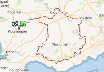
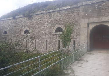
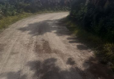
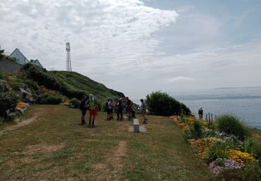
Randonnée V.T.T. de 55 km à découvrir à Bretagne, Finistère, Ploumoguer. Cette randonnée est proposée par tracegps.
Description
Circuit roulant, la plus grosse difficulté est à la fin. La vue sur le goulet de Brest est très sympathique. Goulet= passage de la haute mer à la rade de Brest.
Localisation
Pays :
France
Région :
Bretagne
Département/Province :
Finistère
Commune :
Ploumoguer
Localité :
Unknown
Départ:(Dec)
Départ:(UTM)
372833 ; 5362739 (30U) N.
Commentaires
Randonnées à proximité
![Randonnée Marche Lampaul-Plouarzel - N°12a Lampaul-Plouarzel (Plage de Porspaul) - Conquet - Photo](https://media.geolcdn.com/t/375/260/ext.jpg?maxdim=2&url=https%3A%2F%2Fstatic1.geolcdn.com%2Fsiteimages%2Fupload%2Ffiles%2F1553511878bg_sport_marche.png)
![Marche Marche](https://static1.geolcdn.com/sitytour/trail-icons/101.png)
N°12a Lampaul-Plouarzel (Plage de Porspaul) - Conquet
Marche
Très difficile
(1)
Lampaul-Plouarzel,
Bretagne,
Finistère,
France
![](/images/other/stat-length.png)
20 km | 24 km-effort
5h 29min
![](https://static1.geolcdn.com/siteimages/upload/files/16400158638029165_repeat_loop_refresh_sync_direction_icon.png)
Non
![Randonnée Marche Ploumoguer - Blanc sablons - Photo](https://media.geolcdn.com/t/375/260/9f8a13a6-9108-4438-83a6-64ac4ed746a2.jpg&format=jpg&maxdim=2)
![Marche Marche](https://static1.geolcdn.com/sitytour/trail-icons/101.png)
Blanc sablons
Marche
(1)
Ploumoguer,
Bretagne,
Finistère,
France
![](/images/other/stat-length.png)
15,5 km | 18,9 km-effort
4h 31min
![](https://static1.geolcdn.com/siteimages/upload/files/16400158638029165_repeat_loop_refresh_sync_direction_icon.png)
Oui
![Randonnée A pied Le Conquet - Pte Ker Morvan face à Le Conquet 10-11km D150m - Photo](https://media.geolcdn.com/t/375/260/ext.jpg?maxdim=2&url=https%3A%2F%2Fstatic1.geolcdn.com%2Fsiteimages%2Fupload%2Ffiles%2F1545311037marcheuse_200dpi.jpg)
![A pied A pied](https://static1.geolcdn.com/sitytour/trail-icons/100.png)
Pte Ker Morvan face à Le Conquet 10-11km D150m
A pied
Facile
(1)
Le Conquet,
Bretagne,
Finistère,
France
![](/images/other/stat-length.png)
9,4 km | 11 km-effort
2h 30min
![](https://static1.geolcdn.com/siteimages/upload/files/16400158638029165_repeat_loop_refresh_sync_direction_icon.png)
Oui
![Randonnée Marche Lampaul-Plouarzel - 09.09.23 Lampaul- Plouarzel -- Le Conquet - Photo](https://media.geolcdn.com/t/375/260/888d86e8-0fc8-4dcf-a126-61bf014bddca.jpg&format=jpg&maxdim=2)
![Marche Marche](https://static1.geolcdn.com/sitytour/trail-icons/101.png)
09.09.23 Lampaul- Plouarzel -- Le Conquet
Marche
Très difficile
Lampaul-Plouarzel,
Bretagne,
Finistère,
France
![](/images/other/stat-length.png)
21 km | 26 km-effort
5h 49min
![](https://static1.geolcdn.com/siteimages/upload/files/16400158638029165_repeat_loop_refresh_sync_direction_icon.png)
Non
![Randonnée Marche Le Conquet - Le conquet blancs sablons Trezien - Photo](https://media.geolcdn.com/t/375/260/905a5083-f0f2-466e-8fa0-b8ec674abc06.jpg&format=jpg&maxdim=2)
![Marche Marche](https://static1.geolcdn.com/sitytour/trail-icons/101.png)
Le conquet blancs sablons Trezien
Marche
Moyen
Le Conquet,
Bretagne,
Finistère,
France
![](/images/other/stat-length.png)
21 km | 26 km-effort
4h 56min
![](https://static1.geolcdn.com/siteimages/upload/files/16400158638029165_repeat_loop_refresh_sync_direction_icon.png)
Oui
![Randonnée Marche Le Conquet - Le conquet kermorvan - Photo](https://media.geolcdn.com/t/375/260/03089a66-c39c-48c6-9931-1211906b4ea8.jpg&format=jpg&maxdim=2)
![Marche Marche](https://static1.geolcdn.com/sitytour/trail-icons/101.png)
Le conquet kermorvan
Marche
Moyen
Le Conquet,
Bretagne,
Finistère,
France
![](/images/other/stat-length.png)
10,2 km | 12,1 km-effort
2h 58min
![](https://static1.geolcdn.com/siteimages/upload/files/16400158638029165_repeat_loop_refresh_sync_direction_icon.png)
Oui
![Randonnée Marche nordique Le Conquet - au sud du Conquet - Photo](https://media.geolcdn.com/t/375/260/7bfd0afd-c986-434b-b249-395550ba3672.jpg&format=jpg&maxdim=2)
![Marche nordique Marche nordique](https://static1.geolcdn.com/sitytour/trail-icons/102.png)
au sud du Conquet
Marche nordique
Très facile
Le Conquet,
Bretagne,
Finistère,
France
![](/images/other/stat-length.png)
42 km | 50 km-effort
22min
![](https://static1.geolcdn.com/siteimages/upload/files/16400158638029165_repeat_loop_refresh_sync_direction_icon.png)
Non
![Randonnée Marche Lampaul-Plouarzel - Lanpaul - Lochrist - Photo](https://media.geolcdn.com/t/375/260/ef6f4209-61ed-4c81-8584-8b20cf3e3c1d.jpg&format=jpg&maxdim=2)
![Marche Marche](https://static1.geolcdn.com/sitytour/trail-icons/101.png)
Lanpaul - Lochrist
Marche
Moyen
Lampaul-Plouarzel,
Bretagne,
Finistère,
France
![](/images/other/stat-length.png)
19,8 km | 24 km-effort
5h 7min
![](https://static1.geolcdn.com/siteimages/upload/files/16400158638029165_repeat_loop_refresh_sync_direction_icon.png)
Non
![Randonnée Marche Le Conquet - presqu'île de Kermorvan - Photo](https://media.geolcdn.com/t/375/260/ext.jpg?maxdim=2&url=https%3A%2F%2Fstatic1.geolcdn.com%2Fsiteimages%2Fupload%2Ffiles%2F1553511878bg_sport_marche.png)
![Marche Marche](https://static1.geolcdn.com/sitytour/trail-icons/101.png)
presqu'île de Kermorvan
Marche
Facile
(2)
Le Conquet,
Bretagne,
Finistère,
France
![](/images/other/stat-length.png)
10 km | 11,8 km-effort
2h 54min
![](https://static1.geolcdn.com/siteimages/upload/files/16400158638029165_repeat_loop_refresh_sync_direction_icon.png)
Oui