![](/images/other/stat-length.png)
![Randonnée V.T.T. Laval - Laval par le Genest et Olivet - Photo](https://media.geolcdn.com/t/1900/400/ext.pjpeg?maxdim=2&url=https%3A%2F%2Fservices.sitytrail.com%2FGeolivesWS%2FDownloadMedia.ashx%3FTrailID%3D172863%26Media%3D14315_5.jpg)
Laval par le Genest et Olivet
tracegps
Utilisateur
![Longueur](/images/other/stat-length.png)
Longueur
42 km
![Altitude max](https://static1.geolcdn.com/siteimages/upload/files/1508320355ic_sort_altitude_max_24dp.png)
Altitude max
167 m
![Dénivelé positif](https://static1.geolcdn.com/siteimages/upload/files/1508320355ic_sort_den_pos_24dp.png)
Dénivelé positif
480 m
![Km-Effort](/images/other/stat-length.png)
Km-Effort
48 km
![Altitude min](https://static1.geolcdn.com/siteimages/upload/files/1508320355ic_sort_altitude_min_24dp.png)
Altitude min
77 m
![Dénivelé négatif](https://static1.geolcdn.com/siteimages/upload/files/1508320355ic_sort_den_neg_24dp.png)
Dénivelé négatif
479 m
![Boucle](https://static1.geolcdn.com/siteimages/upload/files/16400158638029165_repeat_loop_refresh_sync_direction_icon.png)
Boucle
Oui
Date de création :
2014-12-10 00:00:00.0
Dernière modification :
2014-12-10 00:00:00.0
![V.T.T.](https://static1.geolcdn.com/sitytour/trail-icons/202.png)
3h00
Difficulté : Moyen
![Scannez ce code QR pour ouvrir la randonnée dans l'application SityTrail](https://capi.geolives.com/qq0zvz2zws4bq2lad0pu/sitytour/trails/172863/qr.png?size=200)
Application GPS de randonnée GRATUITE
À propos
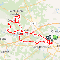
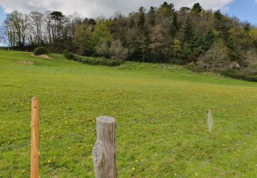
Randonnée V.T.T. de 42 km à découvrir à Pays de la Loire, Mayenne, Laval. Cette randonnée est proposée par tracegps.
Description
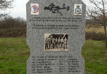
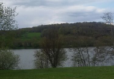
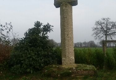
Passage par les marches de Bretagne. Site à voir : l'abbaye de Clermont à coté d'Olivet. Circuit à faire en période de sécheresse sinon quelques passages très boueux.
Localisation
Pays :
France
Région :
Pays de la Loire
Département/Province :
Mayenne
Commune :
Laval
Localité :
Unknown
Départ:(Dec)
Départ:(UTM)
663950 ; 5327336 (30U) N.
Commentaires
Randonnées à proximité
![Randonnée V.T.T. Laval - Saint Berthevin par le golf de Change et Ecologia à Louverné - Photo](https://media.geolcdn.com/t/375/260/ext.jpg?maxdim=2&url=https%3A%2F%2Fservices.sitytrail.com%2FGeolivesWS%2FDownloadMedia.ashx%3FTrailID%3D118719%26Media%3D12908_2.jpg)
![V.T.T. V.T.T.](https://static1.geolcdn.com/sitytour/trail-icons/202.png)
Saint Berthevin par le golf de Change et Ecologia à Louverné
V.T.T.
Difficile
(1)
Laval,
Pays de la Loire,
Mayenne,
France
![](/images/other/stat-length.png)
40 km | 46 km-effort
2h 30min
![](https://static1.geolcdn.com/siteimages/upload/files/16400158638029165_repeat_loop_refresh_sync_direction_icon.png)
Oui
![Randonnée Marche Laval - Tour du pays de Laval(bois de l'Huisserie , Nuillé sur Vicoin) - Photo](https://media.geolcdn.com/t/375/260/ext.jpg?maxdim=2&url=https%3A%2F%2Fservices.sitytrail.com%2FGeolivesWS%2FDownloadMedia.ashx%3FTrailID%3D725470%26Media%3Dfix__20170402181328.jpg)
![Marche Marche](https://static1.geolcdn.com/sitytour/trail-icons/101.png)
Tour du pays de Laval(bois de l'Huisserie , Nuillé sur Vicoin)
Marche
Moyen
Laval,
Pays de la Loire,
Mayenne,
France
![](/images/other/stat-length.png)
15,8 km | 19 km-effort
3h 15min
![](https://static1.geolcdn.com/siteimages/upload/files/16400158638029165_repeat_loop_refresh_sync_direction_icon.png)
Non
![Randonnée Marche Laval - tour du pays de laval (Laval, bois de l'Huisserie)l - Photo](https://media.geolcdn.com/t/375/260/ext.jpg?maxdim=2&url=https%3A%2F%2Fservices.sitytrail.com%2FGeolivesWS%2FDownloadMedia.ashx%3FTrailID%3D697748%26Media%3Dfix__20170212170933.jpg)
![Marche Marche](https://static1.geolcdn.com/sitytour/trail-icons/101.png)
tour du pays de laval (Laval, bois de l'Huisserie)l
Marche
Facile
Laval,
Pays de la Loire,
Mayenne,
France
![](/images/other/stat-length.png)
14,7 km | 17,2 km-effort
2h 55min
![](https://static1.geolcdn.com/siteimages/upload/files/16400158638029165_repeat_loop_refresh_sync_direction_icon.png)
Non
![Randonnée Marche Changé - Changé tour du golf - Photo](https://media.geolcdn.com/t/375/260/ext.jpg?maxdim=2&url=https%3A%2F%2Fservices.sitytrail.com%2FGeolivesWS%2FDownloadMedia.ashx%3FTrailID%3D554957%26Media%3Dfix__20160417171039.jpg)
![Marche Marche](https://static1.geolcdn.com/sitytour/trail-icons/101.png)
Changé tour du golf
Marche
Moyen
Changé,
Pays de la Loire,
Mayenne,
France
![](/images/other/stat-length.png)
9,3 km | 10,9 km-effort
2h 0min
![](https://static1.geolcdn.com/siteimages/upload/files/16400158638029165_repeat_loop_refresh_sync_direction_icon.png)
Oui
![Randonnée V.T.T. Laval - Laval par le bois de l'Huisserie, le bois de Gamats et St Pierre le Potier - Photo](https://media.geolcdn.com/t/375/260/ext.jpg?maxdim=2&url=https%3A%2F%2Fservices.sitytrail.com%2FGeolivesWS%2FDownloadMedia.ashx%3FTrailID%3D129699%26Media%3D13238_3.jpg)
![V.T.T. V.T.T.](https://static1.geolcdn.com/sitytour/trail-icons/202.png)
Laval par le bois de l'Huisserie, le bois de Gamats et St Pierre le Potier
V.T.T.
Difficile
Laval,
Pays de la Loire,
Mayenne,
France
![](/images/other/stat-length.png)
42 km | 49 km-effort
3h 15min
![](https://static1.geolcdn.com/siteimages/upload/files/16400158638029165_repeat_loop_refresh_sync_direction_icon.png)
Oui
![Randonnée A pied Changé - Sentier de randonnée pédestre #10 - Photo](https://media.geolcdn.com/t/375/260/67db2f05-4ef1-49bc-b8cb-2aabe0b67e8f.jpeg&format=jpg&maxdim=2)
![A pied A pied](https://static1.geolcdn.com/sitytour/trail-icons/100.png)
Sentier de randonnée pédestre #10
A pied
Facile
Changé,
Pays de la Loire,
Mayenne,
France
![](/images/other/stat-length.png)
5,3 km | 6 km-effort
1h 22min
![](https://static1.geolcdn.com/siteimages/upload/files/16400158638029165_repeat_loop_refresh_sync_direction_icon.png)
Non
![Randonnée Marche L'Huisserie - Autour de L'Huisserie vers Entammes - Photo](https://media.geolcdn.com/t/375/260/a6eda134-3a58-4ba9-a822-77c4c89ff710.jpg&format=jpg&maxdim=2)
![Marche Marche](https://static1.geolcdn.com/sitytour/trail-icons/101.png)
Autour de L'Huisserie vers Entammes
Marche
Moyen
L'Huisserie,
Pays de la Loire,
Mayenne,
France
![](/images/other/stat-length.png)
12,1 km | 14,9 km-effort
2h 52min
![](https://static1.geolcdn.com/siteimages/upload/files/16400158638029165_repeat_loop_refresh_sync_direction_icon.png)
Oui
![Randonnée Marche L'Huisserie - Tour de l'Huisserie - Photo](https://media.geolcdn.com/t/375/260/ext.jpg?maxdim=2&url=https%3A%2F%2Fservices.sitytrail.com%2FGeolivesWS%2FDownloadMedia.ashx%3FTrailID%3D826332%26Media%3Dfix__20151227155200.jpg)
![Marche Marche](https://static1.geolcdn.com/sitytour/trail-icons/101.png)
Tour de l'Huisserie
Marche
Facile
L'Huisserie,
Pays de la Loire,
Mayenne,
France
![](/images/other/stat-length.png)
11 km | 13 km-effort
2h 10min
![](https://static1.geolcdn.com/siteimages/upload/files/16400158638029165_repeat_loop_refresh_sync_direction_icon.png)
Oui
![Randonnée Autre activité Laval - fifi - Photo](https://media.geolcdn.com/t/375/260/ext.jpg?maxdim=2&url=https%3A%2F%2Fstatic1.geolcdn.com%2Fsiteimages%2Fupload%2Ffiles%2F1545311037marcheuse_200dpi.jpg)
![Autre activité Autre activité](https://static1.geolcdn.com/sitytour/trail-icons/900.png)
fifi
Autre activité
Très facile
Laval,
Pays de la Loire,
Mayenne,
France
![](/images/other/stat-length.png)
32 km | 37 km-effort
28min
![](https://static1.geolcdn.com/siteimages/upload/files/16400158638029165_repeat_loop_refresh_sync_direction_icon.png)
Non