![](/images/other/stat-length.png)
![Randonnée Marche Noyers-sur-Jabron - La Faïrotte - Photo](https://media.geolcdn.com/t/1900/400/ext.pjpeg?maxdim=2&url=https%3A%2F%2Fservices.sitytrail.com%2FGeolivesWS%2FDownloadMedia.ashx%3FTrailID%3D172806%26Media%3D14237_3.jpg)
La Faïrotte
tracegps
Utilisateur
![Longueur](/images/other/stat-length.png)
Longueur
11,6 km
![Altitude max](https://static1.geolcdn.com/siteimages/upload/files/1508320355ic_sort_altitude_max_24dp.png)
Altitude max
1294 m
![Dénivelé positif](https://static1.geolcdn.com/siteimages/upload/files/1508320355ic_sort_den_pos_24dp.png)
Dénivelé positif
429 m
![Km-Effort](/images/other/stat-length.png)
Km-Effort
17,3 km
![Altitude min](https://static1.geolcdn.com/siteimages/upload/files/1508320355ic_sort_altitude_min_24dp.png)
Altitude min
873 m
![Dénivelé négatif](https://static1.geolcdn.com/siteimages/upload/files/1508320355ic_sort_den_neg_24dp.png)
Dénivelé négatif
429 m
![Boucle](https://static1.geolcdn.com/siteimages/upload/files/16400158638029165_repeat_loop_refresh_sync_direction_icon.png)
Boucle
Oui
Date de création :
2014-12-10 00:00:00.0
Dernière modification :
2014-12-10 00:00:00.0
![Marche](https://static1.geolcdn.com/sitytour/trail-icons/101.png)
3h30
Difficulté : Difficile
![Scannez ce code QR pour ouvrir la randonnée dans l'application SityTrail](https://capi.geolives.com/qq0zvz2zws4bq2lad0pu/sitytour/trails/172806/qr.png?size=200)
Application GPS de randonnée GRATUITE
À propos
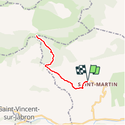
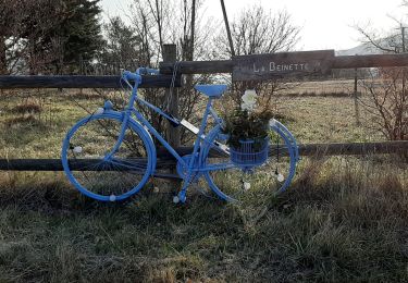
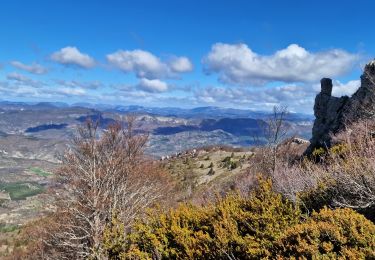
Randonnée Marche de 11,6 km à découvrir à Provence-Alpes-Côte d'Azur, Alpes-de-Haute-Provence, Noyers-sur-Jabron. Cette randonnée est proposée par tracegps.
Description
Allez-Retour sur une piste forestière. De St Martin (commune de Noyers sur Jabron) prendre le GR6 jusqu'au croisement de La Faïrotte à 1288 m d'altitude.
Localisation
Pays :
France
Région :
Provence-Alpes-Côte d'Azur
Département/Province :
Alpes-de-Haute-Provence
Commune :
Noyers-sur-Jabron
Localité :
Unknown
Départ:(Dec)
Départ:(UTM)
723048 ; 4896428 (31T) N.
Commentaires
Randonnées à proximité
![Randonnée Marche Saint-Vincent-sur-Jabron - SAINT VINCENT DU JABRON . Aubard , vieux Curel , chateau des Graves o l s - Photo](https://media.geolcdn.com/t/375/260/224a29dc-57ab-4460-b161-8fc4759a6807.jpg&format=jpg&maxdim=2)
![Marche Marche](https://static1.geolcdn.com/sitytour/trail-icons/101.png)
SAINT VINCENT DU JABRON . Aubard , vieux Curel , chateau des Graves o l s
Marche
Difficile
(1)
Saint-Vincent-sur-Jabron,
Provence-Alpes-Côte d'Azur,
Alpes-de-Haute-Provence,
France
![](/images/other/stat-length.png)
16,1 km | 24 km-effort
4h 53min
![](https://static1.geolcdn.com/siteimages/upload/files/16400158638029165_repeat_loop_refresh_sync_direction_icon.png)
Oui
![Randonnée Marche Saint-Vincent-sur-Jabron - 2024-10-13 Saint Vincent sur Jabron- Pas de Parandier - Photo](https://media.geolcdn.com/t/375/260/c705e38e-601a-4854-bd06-f75f3efcc7e8.jpg&format=jpg&maxdim=2)
![Marche Marche](https://static1.geolcdn.com/sitytour/trail-icons/101.png)
2024-10-13 Saint Vincent sur Jabron- Pas de Parandier
Marche
Très difficile
Saint-Vincent-sur-Jabron,
Provence-Alpes-Côte d'Azur,
Alpes-de-Haute-Provence,
France
![](/images/other/stat-length.png)
14,1 km | 22 km-effort
5h 1min
![](https://static1.geolcdn.com/siteimages/upload/files/16400158638029165_repeat_loop_refresh_sync_direction_icon.png)
Oui
![Randonnée Marche Noyers-sur-Jabron - Noyers sur Jabron - Crête de l'Ane - Photo](https://media.geolcdn.com/t/375/260/b5b69900-a4cf-40a0-8395-e0fe0112d265.jpg&format=jpg&maxdim=2)
![Marche Marche](https://static1.geolcdn.com/sitytour/trail-icons/101.png)
Noyers sur Jabron - Crête de l'Ane
Marche
Difficile
Noyers-sur-Jabron,
Provence-Alpes-Côte d'Azur,
Alpes-de-Haute-Provence,
France
![](/images/other/stat-length.png)
13,3 km | 24 km-effort
5h 28min
![](https://static1.geolcdn.com/siteimages/upload/files/16400158638029165_repeat_loop_refresh_sync_direction_icon.png)
Oui
![Randonnée Marche Saint-Vincent-sur-Jabron - SAINT VINCENT DU JABRON. Aubard, col de Verdun , le pied du mulet o l m s - Photo](https://media.geolcdn.com/t/375/260/9bf08486-a2a4-4953-a4bf-9ce23f6d6e8d.jpg&format=jpg&maxdim=2)
![Marche Marche](https://static1.geolcdn.com/sitytour/trail-icons/101.png)
SAINT VINCENT DU JABRON. Aubard, col de Verdun , le pied du mulet o l m s
Marche
Moyen
Saint-Vincent-sur-Jabron,
Provence-Alpes-Côte d'Azur,
Alpes-de-Haute-Provence,
France
![](/images/other/stat-length.png)
13,3 km | 23 km-effort
3h 48min
![](https://static1.geolcdn.com/siteimages/upload/files/16400158638029165_repeat_loop_refresh_sync_direction_icon.png)
Oui
![Randonnée Marche Saint-Vincent-sur-Jabron - SAINT VINCENT SUR JABRON. Pas de Parandier ,montagne S Michel o n - Photo](https://media.geolcdn.com/t/375/260/05bd1fc9-c51a-44b4-a53f-1799b3b164e7.jpg&format=jpg&maxdim=2)
![Marche Marche](https://static1.geolcdn.com/sitytour/trail-icons/101.png)
SAINT VINCENT SUR JABRON. Pas de Parandier ,montagne S Michel o n
Marche
Moyen
Saint-Vincent-sur-Jabron,
Provence-Alpes-Côte d'Azur,
Alpes-de-Haute-Provence,
France
![](/images/other/stat-length.png)
14,4 km | 23 km-effort
4h 13min
![](https://static1.geolcdn.com/siteimages/upload/files/16400158638029165_repeat_loop_refresh_sync_direction_icon.png)
Oui
![Randonnée Marche Saint-Vincent-sur-Jabron - Rando des Crêtes de Mare (Jabron 02 2025 - Photo](https://media.geolcdn.com/t/375/260/07eb8eef-ead0-4539-8c1f-ea13ee0a71b1.jpg&format=jpg&maxdim=2)
![Marche Marche](https://static1.geolcdn.com/sitytour/trail-icons/101.png)
Rando des Crêtes de Mare (Jabron 02 2025
Marche
Moyen
Saint-Vincent-sur-Jabron,
Provence-Alpes-Côte d'Azur,
Alpes-de-Haute-Provence,
France
![](/images/other/stat-length.png)
17,2 km | 26 km-effort
5h 50min
![](https://static1.geolcdn.com/siteimages/upload/files/16400158638029165_repeat_loop_refresh_sync_direction_icon.png)
Non
![Randonnée Marche Val-Buëch-Méouge - Crête de l'âne, des Planes et Roc de Gloritte Via Plaugiers - Photo](https://media.geolcdn.com/t/375/260/4d865235-32fc-413e-9d16-081082317d85.jpg&format=jpg&maxdim=2)
![Marche Marche](https://static1.geolcdn.com/sitytour/trail-icons/101.png)
Crête de l'âne, des Planes et Roc de Gloritte Via Plaugiers
Marche
Très difficile
Val-Buëch-Méouge,
Provence-Alpes-Côte d'Azur,
Hautes-Alpes,
France
![](/images/other/stat-length.png)
11,1 km | 23 km-effort
5h 19min
![](https://static1.geolcdn.com/siteimages/upload/files/16400158638029165_repeat_loop_refresh_sync_direction_icon.png)
Oui
![Randonnée Marche Noyers-sur-Jabron - Pas du long Rocher - Montagne de Pélegrine - Pas des portes - Photo](https://media.geolcdn.com/t/375/260/9e465827-c241-4f40-9a13-784ef9be38b0.jpg&format=jpg&maxdim=2)
![Marche Marche](https://static1.geolcdn.com/sitytour/trail-icons/101.png)
Pas du long Rocher - Montagne de Pélegrine - Pas des portes
Marche
Très difficile
Noyers-sur-Jabron,
Provence-Alpes-Côte d'Azur,
Alpes-de-Haute-Provence,
France
![](/images/other/stat-length.png)
19,3 km | 32 km-effort
7h 15min
![](https://static1.geolcdn.com/siteimages/upload/files/16400158638029165_repeat_loop_refresh_sync_direction_icon.png)
Oui
![Randonnée Marche Saint-Vincent-sur-Jabron - Crête Montagne de Mare Via St Vincent sur Jabron - Photo](https://media.geolcdn.com/t/375/260/1baeea92-ca4d-4ee3-92e8-21a8cf9e9e85.jpg&format=jpg&maxdim=2)
![Marche Marche](https://static1.geolcdn.com/sitytour/trail-icons/101.png)
Crête Montagne de Mare Via St Vincent sur Jabron
Marche
Très difficile
Saint-Vincent-sur-Jabron,
Provence-Alpes-Côte d'Azur,
Alpes-de-Haute-Provence,
France
![](/images/other/stat-length.png)
14,8 km | 25 km-effort
5h 44min
![](https://static1.geolcdn.com/siteimages/upload/files/16400158638029165_repeat_loop_refresh_sync_direction_icon.png)
Oui