![](/images/other/stat-length.png)
![Randonnée Marche Dieulefit - Tour du Pays de Dieulefit - Dieulefit à Eyzahut - Photo](https://media.geolcdn.com/t/1900/400/ext.pjpeg?maxdim=2&url=https%3A%2F%2Fservices.sitytrail.com%2FGeolivesWS%2FDownloadMedia.ashx%3FTrailID%3D172801%26Media%3D14231_5.jpg)
Tour du Pays de Dieulefit - Dieulefit à Eyzahut
tracegps
Utilisateur
![Longueur](/images/other/stat-length.png)
![Altitude max](https://static1.geolcdn.com/siteimages/upload/files/1508320355ic_sort_altitude_max_24dp.png)
![Dénivelé positif](https://static1.geolcdn.com/siteimages/upload/files/1508320355ic_sort_den_pos_24dp.png)
![Km-Effort](/images/other/stat-length.png)
![Altitude min](https://static1.geolcdn.com/siteimages/upload/files/1508320355ic_sort_altitude_min_24dp.png)
![Dénivelé négatif](https://static1.geolcdn.com/siteimages/upload/files/1508320355ic_sort_den_neg_24dp.png)
![Boucle](https://static1.geolcdn.com/siteimages/upload/files/16400158638029165_repeat_loop_refresh_sync_direction_icon.png)
![Marche](https://static1.geolcdn.com/sitytour/trail-icons/101.png)
4h00
Difficulté : Difficile
![Scannez ce code QR pour ouvrir la randonnée dans l'application SityTrail](https://capi.geolives.com/qq0zvz2zws4bq2lad0pu/sitytour/trails/172801/qr.png?size=200)
Application GPS de randonnée GRATUITE
À propos
Randonnée Marche de 12,8 km à découvrir à Auvergne-Rhône-Alpes, Drôme, Dieulefit. Cette randonnée est proposée par tracegps.
Description
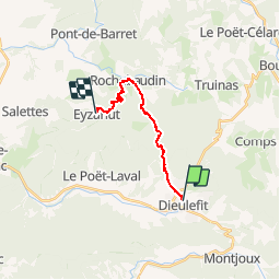
Huitième étape : après une montée de 400m dans la forêt de St Maurice, la descente à partir du col du Pertuis (884m) vous fait rejoindre Rochebaudin (330m) avant de vous diriger vers Eyzahut (504m). Retrouvez le plan global du circuit sur le site de la Communauté de Communes du pays de Dieulefit.
Localisation
Commentaires
Randonnées à proximité
![Randonnée A pied Eyzahut - Randotrail Eyzahut Poet Laval (Trou du Furet, La Tournelle, Serre Gros) - Photo](https://media.geolcdn.com/t/375/260/18dbfece-5a68-4dfb-9f06-5bb6196c6685.jpg&format=jpg&maxdim=2)
![A pied A pied](https://static1.geolcdn.com/sitytour/trail-icons/100.png)
A pied
![](/images/other/stat-length.png)
![](https://static1.geolcdn.com/siteimages/upload/files/16400158638029165_repeat_loop_refresh_sync_direction_icon.png)
![Randonnée Marche Montjoux - Le Devès - Montjoux - Photo](https://media.geolcdn.com/t/375/260/ext.jpg?maxdim=2&url=https%3A%2F%2Fservices.sitytrail.com%2FGeolivesWS%2FDownloadMedia.ashx%3FTrailID%3D172804%26Media%3D14234_5.jpg)
![Marche Marche](https://static1.geolcdn.com/sitytour/trail-icons/101.png)
Marche
![](/images/other/stat-length.png)
![](https://static1.geolcdn.com/siteimages/upload/files/16400158638029165_repeat_loop_refresh_sync_direction_icon.png)
![Randonnée Marche Dieulefit - 26 dieulefit chap st Maurice vitrouilleres - Photo](https://media.geolcdn.com/t/375/260/9032ba92-359b-417c-8863-3a326ab807ba.jpg&format=jpg&maxdim=2)
![Marche Marche](https://static1.geolcdn.com/sitytour/trail-icons/101.png)
Marche
![](/images/other/stat-length.png)
![](https://static1.geolcdn.com/siteimages/upload/files/16400158638029165_repeat_loop_refresh_sync_direction_icon.png)
![Randonnée Marche Le Poët-Laval - Poët-Laval Les vitrouilléres (La Dame Blanche) 9km. - Photo](https://media.geolcdn.com/t/375/260/aa6f7aee-41bd-433a-b904-1eda7a964ff6.jpg&format=jpg&maxdim=2)
![Marche Marche](https://static1.geolcdn.com/sitytour/trail-icons/101.png)
Marche
![](/images/other/stat-length.png)
![](https://static1.geolcdn.com/siteimages/upload/files/16400158638029165_repeat_loop_refresh_sync_direction_icon.png)
![Randonnée Marche Le Poët-Laval - Le Poet Laval : Le Trou du Furet 6km5 - Photo](https://media.geolcdn.com/t/375/260/e856c3d2-cc59-44f2-9430-12ee63613b6b.jpg&format=jpg&maxdim=2)
![Marche Marche](https://static1.geolcdn.com/sitytour/trail-icons/101.png)
Marche
![](/images/other/stat-length.png)
![](https://static1.geolcdn.com/siteimages/upload/files/16400158638029165_repeat_loop_refresh_sync_direction_icon.png)
![Randonnée Marche Montjoux - Montjoux 6km2 - Photo](https://media.geolcdn.com/t/375/260/cbc34adf-c509-4a94-9b7f-6317c0990136.jpg&format=jpg&maxdim=2)
![Marche Marche](https://static1.geolcdn.com/sitytour/trail-icons/101.png)
Marche
![](/images/other/stat-length.png)
![](https://static1.geolcdn.com/siteimages/upload/files/16400158638029165_repeat_loop_refresh_sync_direction_icon.png)
![Randonnée Marche Dieulefit - Chapelle St Maurice 10km. - Photo](https://media.geolcdn.com/t/375/260/70a2cb51-e6fc-4007-ba36-e4a050e05f72.jpg&format=jpg&maxdim=2)
![Marche Marche](https://static1.geolcdn.com/sitytour/trail-icons/101.png)
Marche
![](/images/other/stat-length.png)
![](https://static1.geolcdn.com/siteimages/upload/files/16400158638029165_repeat_loop_refresh_sync_direction_icon.png)
![Randonnée Marche Roche-Saint-Secret-Béconne - 26montjoux - Photo](https://media.geolcdn.com/t/375/260/a6833288-f9f8-48b3-afa2-e10324484402.jpg&format=jpg&maxdim=2)
![Marche Marche](https://static1.geolcdn.com/sitytour/trail-icons/101.png)
Marche
![](/images/other/stat-length.png)
![](https://static1.geolcdn.com/siteimages/upload/files/16400158638029165_repeat_loop_refresh_sync_direction_icon.png)
![Randonnée Marche Le Poët-Laval - Le poët laval - Photo](https://media.geolcdn.com/t/375/260/ext.jpg?maxdim=2&url=https%3A%2F%2Fstatic1.geolcdn.com%2Fsiteimages%2Fupload%2Ffiles%2F1553511878bg_sport_marche.png)
![Marche Marche](https://static1.geolcdn.com/sitytour/trail-icons/101.png)
Marche
![](/images/other/stat-length.png)
![](https://static1.geolcdn.com/siteimages/upload/files/16400158638029165_repeat_loop_refresh_sync_direction_icon.png)