![](/images/other/stat-length.png)
![Randonnée V.T.T. Douarnenez - Finistère Sud : Pointe du Raz - Douarnenez - Photo](https://media.geolcdn.com/t/1900/400/ext.pjpeg?maxdim=2&url=https%3A%2F%2Fservices.sitytrail.com%2FGeolivesWS%2FDownloadMedia.ashx%3FTrailID%3D172574%26Media%3D13941_1.jpg)
Finistère Sud : Pointe du Raz - Douarnenez
tracegps
Utilisateur
![Longueur](/images/other/stat-length.png)
![Altitude max](https://static1.geolcdn.com/siteimages/upload/files/1508320355ic_sort_altitude_max_24dp.png)
![Dénivelé positif](https://static1.geolcdn.com/siteimages/upload/files/1508320355ic_sort_den_pos_24dp.png)
![Km-Effort](/images/other/stat-length.png)
![Altitude min](https://static1.geolcdn.com/siteimages/upload/files/1508320355ic_sort_altitude_min_24dp.png)
![Dénivelé négatif](https://static1.geolcdn.com/siteimages/upload/files/1508320355ic_sort_den_neg_24dp.png)
![Boucle](https://static1.geolcdn.com/siteimages/upload/files/16400158638029165_repeat_loop_refresh_sync_direction_icon.png)
![V.T.T.](https://static1.geolcdn.com/sitytour/trail-icons/202.png)
9h00
Difficulté : Moyen
![Scannez ce code QR pour ouvrir la randonnée dans l'application SityTrail](https://capi.geolives.com/qq0zvz2zws4bq2lad0pu/sitytour/trails/172574/qr.png?size=200)
Application GPS de randonnée GRATUITE
À propos
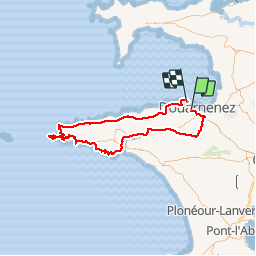
Randonnée V.T.T. de 92 km à découvrir à Bretagne, Finistère, Douarnenez. Cette randonnée est proposée par tracegps.
Description
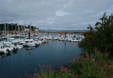
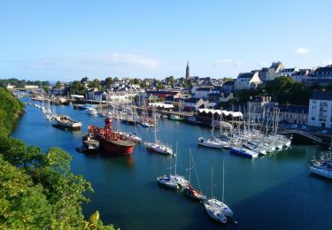
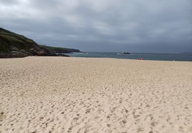
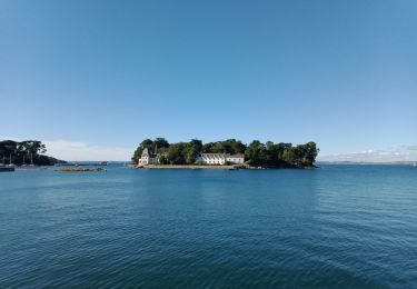
Belle rando en vtt pas très difficile (quasiment que de la route). De Douarnenez, on rejoint Pont-Croix par Pouldergat et Confort Meilars. De Pont Croix à Audierne l'estuaire du Goyen est magnifique. Un petit sentier en fait le tour très bien balisé avec la distance parcourue. De Audierne à la Pointe du Raz le sentier VTT est balisé (en vert) avec les points à visiter: remarquable. A la sortie d"Audierne, la plage de Trez Goarem est magnifique c'est l'une des plus belles plages que j'ai vue. Par contre de Pointe du Raz à Pointe du Van aucun fléchage. Grosse descente vers la Baie des Trepassés. Ensuite on a le choix entre 2 mega montées (j ai pris celle de gauche) pour arriver sur la Pointe du Van. Ensuite 25 km de route jusqu'à Douarnenez par la D7: 30 km avec le vent dans le dos, çà se fait tout seul!
Localisation
Commentaires
Randonnées à proximité
![Randonnée Marche Douarnenez - Douarnenez - GR34 AR les Roches Blanches Pointe de la Jument - 9.3km 250m 3h30 - 2019 09 01 - Photo](https://media.geolcdn.com/t/375/260/ab448e69-f6b6-4c7f-80fa-8b9533bb0920.jpg&format=jpg&maxdim=2)
![Marche Marche](https://static1.geolcdn.com/sitytour/trail-icons/101.png)
Marche
![](/images/other/stat-length.png)
![](https://static1.geolcdn.com/siteimages/upload/files/16400158638029165_repeat_loop_refresh_sync_direction_icon.png)
![Randonnée Marche Douarnenez - TREK RCY GR34 2022 j2 Douarnenez- Beuzec - Photo](https://media.geolcdn.com/t/375/260/8fdd798e-9630-4ffb-bea5-9ee3ec61b3a8.jpg&format=jpg&maxdim=2)
![Marche Marche](https://static1.geolcdn.com/sitytour/trail-icons/101.png)
Marche
![](/images/other/stat-length.png)
![](https://static1.geolcdn.com/siteimages/upload/files/16400158638029165_repeat_loop_refresh_sync_direction_icon.png)
![Randonnée Marche Douarnenez - Trek RCY GR 34 2022- journée 1 Balade Douarnenez - Photo](https://media.geolcdn.com/t/375/260/e6241847-f9f8-4845-8061-377f37ea1e75.jpg&format=jpg&maxdim=2)
![Marche Marche](https://static1.geolcdn.com/sitytour/trail-icons/101.png)
Marche
![](/images/other/stat-length.png)
![](https://static1.geolcdn.com/siteimages/upload/files/16400158638029165_repeat_loop_refresh_sync_direction_icon.png)
![Randonnée A pied Douarnenez - Le chemin de la sardine - Photo](https://media.geolcdn.com/t/375/260/9ce746a4-512e-4653-b738-0ff8fd3fd82c.jpeg&format=jpg&maxdim=2)
![A pied A pied](https://static1.geolcdn.com/sitytour/trail-icons/100.png)
A pied
![](/images/other/stat-length.png)
![](https://static1.geolcdn.com/siteimages/upload/files/16400158638029165_repeat_loop_refresh_sync_direction_icon.png)
![Randonnée Marche Douarnenez - Douarnenez - GR34 du port de plaisance aux Roches Blanches - 9.7km 165m 2h30 - 2019 09 06 - Photo](https://media.geolcdn.com/t/375/260/d1eb9c88-a75c-496a-a8ef-0db250d9eb67.jpg&format=jpg&maxdim=2)
![Marche Marche](https://static1.geolcdn.com/sitytour/trail-icons/101.png)
Marche
![](/images/other/stat-length.png)
![](https://static1.geolcdn.com/siteimages/upload/files/16400158638029165_repeat_loop_refresh_sync_direction_icon.png)
![Randonnée Marche Douarnenez - Douarnenez - du Port Rhu - 5.8km 115m 1h45 - 2019 09 01 - Photo](https://media.geolcdn.com/t/375/260/28ac96a0-9369-40eb-a4d8-7b2ede676873.jpg&format=jpg&maxdim=2)
![Marche Marche](https://static1.geolcdn.com/sitytour/trail-icons/101.png)
Marche
![](/images/other/stat-length.png)
![](https://static1.geolcdn.com/siteimages/upload/files/16400158638029165_repeat_loop_refresh_sync_direction_icon.png)
![Randonnée Marche Douarnenez - GR34 Douarnenez-- Pors Peron - Photo](https://media.geolcdn.com/t/375/260/55c8cb23-826e-4476-a89b-d5fdee2975ce.jpg&format=jpg&maxdim=2)
![Marche Marche](https://static1.geolcdn.com/sitytour/trail-icons/101.png)
Marche
![](/images/other/stat-length.png)
![](https://static1.geolcdn.com/siteimages/upload/files/16400158638029165_repeat_loop_refresh_sync_direction_icon.png)
![Randonnée Marche Douarnenez - DOUARNENEZ - Photo](https://media.geolcdn.com/t/375/260/669ff4fd-0def-4571-a23c-23ec26be7050.jpg&format=jpg&maxdim=2)
![Marche Marche](https://static1.geolcdn.com/sitytour/trail-icons/101.png)
Marche
![](/images/other/stat-length.png)
![](https://static1.geolcdn.com/siteimages/upload/files/16400158638029165_repeat_loop_refresh_sync_direction_icon.png)
![Randonnée Marche Douarnenez - TREK RCY GR34 2022 J1 Balade du soir - Photo](https://media.geolcdn.com/t/375/260/6afdc80c-f966-4c00-935f-4079c9c4567d.jpg&format=jpg&maxdim=2)
![Marche Marche](https://static1.geolcdn.com/sitytour/trail-icons/101.png)
Marche
![](/images/other/stat-length.png)
![](https://static1.geolcdn.com/siteimages/upload/files/16400158638029165_repeat_loop_refresh_sync_direction_icon.png)