![](/images/other/stat-length.png)
![Randonnée Marche Saint-Germain-du-Bois - Balade des Étangs - St Germain du Bois - Photo](https://media.geolcdn.com/t/1900/400/ext.pjpeg?maxdim=2&url=https%3A%2F%2Fservices.sitytrail.com%2FGeolivesWS%2FDownloadMedia.ashx%3FTrailID%3D172248%26Media%3D5917_2.jpg)
Balade des Étangs - St Germain du Bois
tracegps
Utilisateur
![Longueur](/images/other/stat-length.png)
Longueur
20 km
![Altitude max](https://static1.geolcdn.com/siteimages/upload/files/1508320355ic_sort_altitude_max_24dp.png)
Altitude max
215 m
![Dénivelé positif](https://static1.geolcdn.com/siteimages/upload/files/1508320355ic_sort_den_pos_24dp.png)
Dénivelé positif
175 m
![Km-Effort](/images/other/stat-length.png)
Km-Effort
22 km
![Altitude min](https://static1.geolcdn.com/siteimages/upload/files/1508320355ic_sort_altitude_min_24dp.png)
Altitude min
182 m
![Dénivelé négatif](https://static1.geolcdn.com/siteimages/upload/files/1508320355ic_sort_den_neg_24dp.png)
Dénivelé négatif
177 m
![Boucle](https://static1.geolcdn.com/siteimages/upload/files/16400158638029165_repeat_loop_refresh_sync_direction_icon.png)
Boucle
Oui
Date de création :
2014-12-10 00:00:00.0
Dernière modification :
2014-12-10 00:00:00.0
![Marche](https://static1.geolcdn.com/sitytour/trail-icons/101.png)
4h45
Difficulté : Difficile
![Scannez ce code QR pour ouvrir la randonnée dans l'application SityTrail](https://capi.geolives.com/qq0zvz2zws4bq2lad0pu/sitytour/trails/172248/qr.png?size=200)
Application GPS de randonnée GRATUITE
À propos
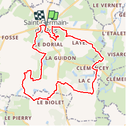
Randonnée Marche de 20 km à découvrir à Bourgogne-Franche-Comté, Saône-et-Loire, Saint-Germain-du-Bois. Cette randonnée est proposée par tracegps.
Description
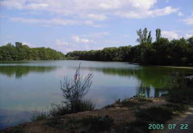
Le circuit au départ de l'église de Saint-Germain-du-Bois, permet de donner une vue sur l'ensemble des étangs au sud de la commune. Retrouvez la carte des circuits de randonnées de la commune sur le site de Saint Germain du Bois.
Localisation
Pays :
France
Région :
Bourgogne-Franche-Comté
Département/Province :
Saône-et-Loire
Commune :
Saint-Germain-du-Bois
Localité :
Unknown
Départ:(Dec)
Départ:(UTM)
671304 ; 5180125 (31T) N.
Commentaires
Randonnées à proximité
![Randonnée Cheval Saint-Germain-du-Bois - Balade des Étangs - St Germain du Bois - Photo](https://media.geolcdn.com/t/375/260/ext.jpg?maxdim=2&url=https%3A%2F%2Fservices.sitytrail.com%2FGeolivesWS%2FDownloadMedia.ashx%3FTrailID%3D172250%26Media%3D5917_2.jpg)
![Cheval Cheval](https://static1.geolcdn.com/sitytour/trail-icons/300.png)
Balade des Étangs - St Germain du Bois
Cheval
Difficile
Saint-Germain-du-Bois,
Bourgogne-Franche-Comté,
Saône-et-Loire,
France
![](/images/other/stat-length.png)
20 km | 22 km-effort
3h 0min
![](https://static1.geolcdn.com/siteimages/upload/files/16400158638029165_repeat_loop_refresh_sync_direction_icon.png)
Oui
![Randonnée V.T.T. Saint-Germain-du-Bois - Balade des Étangs - St Germain du Bois - Photo](https://media.geolcdn.com/t/375/260/ext.jpg?maxdim=2&url=https%3A%2F%2Fservices.sitytrail.com%2FGeolivesWS%2FDownloadMedia.ashx%3FTrailID%3D172249%26Media%3D5917_1.jpg)
![V.T.T. V.T.T.](https://static1.geolcdn.com/sitytour/trail-icons/202.png)
Balade des Étangs - St Germain du Bois
V.T.T.
Difficile
Saint-Germain-du-Bois,
Bourgogne-Franche-Comté,
Saône-et-Loire,
France
![](/images/other/stat-length.png)
20 km | 22 km-effort
1h 45min
![](https://static1.geolcdn.com/siteimages/upload/files/16400158638029165_repeat_loop_refresh_sync_direction_icon.png)
Oui
![Randonnée A pied Simard - Simard , Champ de l' étang , les Peutots , le Meix Chantrault et retour - Photo](https://media.geolcdn.com/t/375/260/ext.jpg?maxdim=2&url=https%3A%2F%2Fstatic1.geolcdn.com%2Fsiteimages%2Fupload%2Ffiles%2F1545311037marcheuse_200dpi.jpg)
![A pied A pied](https://static1.geolcdn.com/sitytour/trail-icons/100.png)
Simard , Champ de l' étang , les Peutots , le Meix Chantrault et retour
A pied
Facile
Simard,
Bourgogne-Franche-Comté,
Saône-et-Loire,
France
![](/images/other/stat-length.png)
5,5 km | 5,8 km-effort
1h 19min
![](https://static1.geolcdn.com/siteimages/upload/files/16400158638029165_repeat_loop_refresh_sync_direction_icon.png)
Oui
![Randonnée Marche Serley - P ou TP . Serley - La Croix - La grande Champonnière - les Vernes Thibert - et retour - Photo](https://media.geolcdn.com/t/375/260/ext.jpg?maxdim=2&url=https%3A%2F%2Fstatic1.geolcdn.com%2Fsiteimages%2Fupload%2Ffiles%2F1553511878bg_sport_marche.png)
![Marche Marche](https://static1.geolcdn.com/sitytour/trail-icons/101.png)
P ou TP . Serley - La Croix - La grande Champonnière - les Vernes Thibert - ...
Marche
Moyen
Serley,
Bourgogne-Franche-Comté,
Saône-et-Loire,
France
![](/images/other/stat-length.png)
6,1 km | 6,5 km-effort
1h 28min
![](https://static1.geolcdn.com/siteimages/upload/files/16400158638029165_repeat_loop_refresh_sync_direction_icon.png)
Oui
![Randonnée Marche Simard - G . Simard - Les Peutots - Le Perroir - la Voirie - Les Toines - et retour - Photo](https://media.geolcdn.com/t/375/260/ext.jpg?maxdim=2&url=https%3A%2F%2Fstatic1.geolcdn.com%2Fsiteimages%2Fupload%2Ffiles%2F1553511878bg_sport_marche.png)
![Marche Marche](https://static1.geolcdn.com/sitytour/trail-icons/101.png)
G . Simard - Les Peutots - Le Perroir - la Voirie - Les Toines - et retour
Marche
Difficile
Simard,
Bourgogne-Franche-Comté,
Saône-et-Loire,
France
![](/images/other/stat-length.png)
12,9 km | 13,9 km-effort
3h 9min
![](https://static1.geolcdn.com/siteimages/upload/files/16400158638029165_repeat_loop_refresh_sync_direction_icon.png)
Oui
![Randonnée Marche Serley - G. Serley - Photo](https://media.geolcdn.com/t/375/260/ext.jpg?maxdim=2&url=https%3A%2F%2Fstatic1.geolcdn.com%2Fsiteimages%2Fupload%2Ffiles%2F1553511878bg_sport_marche.png)
![Marche Marche](https://static1.geolcdn.com/sitytour/trail-icons/101.png)
G. Serley
Marche
Moyen
Serley,
Bourgogne-Franche-Comté,
Saône-et-Loire,
France
![](/images/other/stat-length.png)
10,2 km | 10,9 km-effort
2h 28min
![](https://static1.geolcdn.com/siteimages/upload/files/16400158638029165_repeat_loop_refresh_sync_direction_icon.png)
Oui
![Randonnée Vélo de route Saint-Germain-du-Bois - VI Roanne J3 - Photo](https://media.geolcdn.com/t/375/260/ext.jpg?maxdim=2&url=https%3A%2F%2Fstatic1.geolcdn.com%2Fsiteimages%2Fupload%2Ffiles%2F1524743154velo.jpg)
![Vélo de route Vélo de route](https://static1.geolcdn.com/sitytour/trail-icons/201.png)
VI Roanne J3
Vélo de route
Moyen
Saint-Germain-du-Bois,
Bourgogne-Franche-Comté,
Saône-et-Loire,
France
![](/images/other/stat-length.png)
96 km | 106 km-effort
4h 23min
![](https://static1.geolcdn.com/siteimages/upload/files/16400158638029165_repeat_loop_refresh_sync_direction_icon.png)
Non
![Randonnée V.T.T. Saint-Germain-du-Bois - Vac2021 - etape 4 bis - Photo](https://media.geolcdn.com/t/375/260/ext.jpg?maxdim=2&url=https%3A%2F%2Fstatic1.geolcdn.com%2Fsiteimages%2Fupload%2Ffiles%2F1524743154velo.jpg)
![V.T.T. V.T.T.](https://static1.geolcdn.com/sitytour/trail-icons/202.png)
Vac2021 - etape 4 bis
V.T.T.
Difficile
Saint-Germain-du-Bois,
Bourgogne-Franche-Comté,
Saône-et-Loire,
France
![](/images/other/stat-length.png)
32 km | 36 km-effort
2h 28min
![](https://static1.geolcdn.com/siteimages/upload/files/16400158638029165_repeat_loop_refresh_sync_direction_icon.png)
Non
![Randonnée V.T.T. Saint-Germain-du-Bois - Vac2021 - Etape 4 je - Photo](https://media.geolcdn.com/t/375/260/ext.jpg?maxdim=2&url=https%3A%2F%2Fstatic1.geolcdn.com%2Fsiteimages%2Fupload%2Ffiles%2F1524743154velo.jpg)
![V.T.T. V.T.T.](https://static1.geolcdn.com/sitytour/trail-icons/202.png)
Vac2021 - Etape 4 je
V.T.T.
Très difficile
Saint-Germain-du-Bois,
Bourgogne-Franche-Comté,
Saône-et-Loire,
France
![](/images/other/stat-length.png)
43 km | 49 km-effort
3h 23min
![](https://static1.geolcdn.com/siteimages/upload/files/16400158638029165_repeat_loop_refresh_sync_direction_icon.png)
Non