![](/images/other/stat-length.png)
![Randonnée Marche Coxyde - St. Idesbald et Noorduinen - Photo](https://media.geolcdn.com/t/1900/400/ext.pjpeg?maxdim=2&url=https%3A%2F%2Fservices.sitytrail.com%2FGeolivesWS%2FDownloadMedia.ashx%3FTrailID%3D168023%26Media%3D20121231143948.jpg)
St. Idesbald et Noorduinen
cdeg62
Utilisateur
![Longueur](/images/other/stat-length.png)
![Altitude max](https://static1.geolcdn.com/siteimages/upload/files/1508320355ic_sort_altitude_max_24dp.png)
![Dénivelé positif](https://static1.geolcdn.com/siteimages/upload/files/1508320355ic_sort_den_pos_24dp.png)
![Km-Effort](/images/other/stat-length.png)
![Altitude min](https://static1.geolcdn.com/siteimages/upload/files/1508320355ic_sort_altitude_min_24dp.png)
![Dénivelé négatif](https://static1.geolcdn.com/siteimages/upload/files/1508320355ic_sort_den_neg_24dp.png)
![Boucle](https://static1.geolcdn.com/siteimages/upload/files/16400158638029165_repeat_loop_refresh_sync_direction_icon.png)
![Marche](https://static1.geolcdn.com/sitytour/trail-icons/101.png)
1h04
Difficulté : Facile
![Scannez ce code QR pour ouvrir la randonnée dans l'application SityTrail](https://capi.geolives.com/qq0zvz2zws4bq2lad0pu/sitytour/trails/168023/qr.png?size=200)
Application GPS de randonnée GRATUITE
À propos
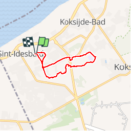
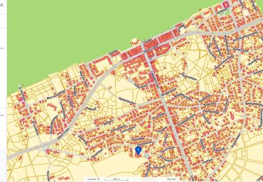
Randonnée Marche de 4,5 km à découvrir à Flandre, Flandre-Occidentale, Coxyde. Cette randonnée est proposée par cdeg62.
Description
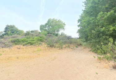
Courte promenade d'environ 1 heure : départ et arrivée dans le quartier des villas de St. Idesbald. La plus grande partie du trajet se fait dans la jolie réserve naturelle de Noorduinen, très diversifiée du point de vue de la flore (seul regret: elle est coupée en deux par une route nationale fort fréquentée).
Localisation
Commentaires
Randonnées à proximité
![Randonnée Marche Coxyde - St. Idesbald et Noorduinen - Photo](https://media.geolcdn.com/t/375/260/ext.jpg?maxdim=2&url=https%3A%2F%2Fservices.sitytrail.com%2FGeolivesWS%2FDownloadMedia.ashx%3FTrailID%3D168018%26Media%3D20121231143948.jpg)
![Marche Marche](https://static1.geolcdn.com/sitytour/trail-icons/101.png)
Marche
![](/images/other/stat-length.png)
![](https://static1.geolcdn.com/siteimages/upload/files/16400158638029165_repeat_loop_refresh_sync_direction_icon.png)
![Randonnée V.T.T. La Panne - 20240613 - TOTEMUS partiel - DE PANNE 16 Km - Photo](https://media.geolcdn.com/t/375/260/e6db3c74-8cd0-422d-a16f-519e8aed2213.jpg&format=jpg&maxdim=2)
![V.T.T. V.T.T.](https://static1.geolcdn.com/sitytour/trail-icons/202.png)
V.T.T.
![](/images/other/stat-length.png)
![](https://static1.geolcdn.com/siteimages/upload/files/16400158638029165_repeat_loop_refresh_sync_direction_icon.png)
![Randonnée Marche La Panne - 20240612 - TOTEMUS De Panne - 6.7 Km - Photo](https://media.geolcdn.com/t/375/260/c5970009-e40d-4347-b90a-1006eb79b5f8.jpg&format=jpg&maxdim=2)
![Marche Marche](https://static1.geolcdn.com/sitytour/trail-icons/101.png)
Marche
![](/images/other/stat-length.png)
![](https://static1.geolcdn.com/siteimages/upload/files/16400158638029165_repeat_loop_refresh_sync_direction_icon.png)
![Randonnée Marche Coxyde - 79.105 Oostduinkerke - Astrid- Astridwandelin - Photo](https://media.geolcdn.com/t/375/260/9479c538-170d-403d-84ed-25176d21a6e6.jpg&format=jpg&maxdim=2)
![Marche Marche](https://static1.geolcdn.com/sitytour/trail-icons/101.png)
Marche
![](/images/other/stat-length.png)
![](https://static1.geolcdn.com/siteimages/upload/files/16400158638029165_repeat_loop_refresh_sync_direction_icon.png)
![Randonnée Marche Coxyde - 20230429 Oostduinkerke 4.2 Km - Photo](https://media.geolcdn.com/t/375/260/3c5d7322-8ab8-4011-bd9d-4e01541f94c3.jpg&format=jpg&maxdim=2)
![Marche Marche](https://static1.geolcdn.com/sitytour/trail-icons/101.png)
Marche
![](/images/other/stat-length.png)
![](https://static1.geolcdn.com/siteimages/upload/files/16400158638029165_repeat_loop_refresh_sync_direction_icon.png)
![Randonnée A pied Coxyde - IJslandvaarders - Photo](https://media.geolcdn.com/t/375/260/ff0167a3-9414-481c-8a7c-f8f5e15aac2c.jpeg&format=jpg&maxdim=2)
![A pied A pied](https://static1.geolcdn.com/sitytour/trail-icons/100.png)
A pied
![](/images/other/stat-length.png)
![](https://static1.geolcdn.com/siteimages/upload/files/16400158638029165_repeat_loop_refresh_sync_direction_icon.png)
![Randonnée A pied Furnes - Stadswandelroute Veurne - Photo](https://media.geolcdn.com/t/375/260/2a68b391-176c-49be-94c2-5b4152bca163.jpeg&format=jpg&maxdim=2)
![A pied A pied](https://static1.geolcdn.com/sitytour/trail-icons/100.png)
A pied
![](/images/other/stat-length.png)
![](https://static1.geolcdn.com/siteimages/upload/files/16400158638029165_repeat_loop_refresh_sync_direction_icon.png)
![Randonnée A pied Coxyde - Polderwandelroute - Photo](https://media.geolcdn.com/t/375/260/6e1733cc-250c-4f6f-a330-e197703f4186.jpeg&format=jpg&maxdim=2)
![A pied A pied](https://static1.geolcdn.com/sitytour/trail-icons/100.png)
A pied
![](/images/other/stat-length.png)
![](https://static1.geolcdn.com/siteimages/upload/files/16400158638029165_repeat_loop_refresh_sync_direction_icon.png)
![Randonnée A pied Coxyde - Artiestenwandelroute - Photo](https://media.geolcdn.com/t/375/260/54053886-9eaa-4fd8-b3ef-a405e8574e3d.jpeg&format=jpg&maxdim=2)
![A pied A pied](https://static1.geolcdn.com/sitytour/trail-icons/100.png)
A pied
![](/images/other/stat-length.png)
![](https://static1.geolcdn.com/siteimages/upload/files/16400158638029165_repeat_loop_refresh_sync_direction_icon.png)