![](/images/other/stat-length.png)
![Randonnée Marche Donges - Donges_Chemin des villages - Photo](https://media.geolcdn.com/t/1900/400/ext.pjpeg?maxdim=2&url=https%3A%2F%2Fstatic1.geolcdn.com%2Fsiteimages%2Fupload%2Ffiles%2F1553511878bg_sport_marche.png)
Donges_Chemin des villages
neoroll44
Utilisateur
![Longueur](/images/other/stat-length.png)
Longueur
9,7 km
![Altitude max](https://static1.geolcdn.com/siteimages/upload/files/1508320355ic_sort_altitude_max_24dp.png)
Altitude max
13 m
![Dénivelé positif](https://static1.geolcdn.com/siteimages/upload/files/1508320355ic_sort_den_pos_24dp.png)
Dénivelé positif
60 m
![Km-Effort](/images/other/stat-length.png)
Km-Effort
10,5 km
![Altitude min](https://static1.geolcdn.com/siteimages/upload/files/1508320355ic_sort_altitude_min_24dp.png)
Altitude min
-1 m
![Dénivelé négatif](https://static1.geolcdn.com/siteimages/upload/files/1508320355ic_sort_den_neg_24dp.png)
Dénivelé négatif
60 m
![Boucle](https://static1.geolcdn.com/siteimages/upload/files/16400158638029165_repeat_loop_refresh_sync_direction_icon.png)
Boucle
Oui
Date de création :
2014-12-10 00:00:00.0
Dernière modification :
2014-12-10 00:00:00.0
![Marche](https://static1.geolcdn.com/sitytour/trail-icons/101.png)
2h20
Difficulté : Facile
![Scannez ce code QR pour ouvrir la randonnée dans l'application SityTrail](https://capi.geolives.com/qq0zvz2zws4bq2lad0pu/sitytour/trails/166479/qr.png?size=200)
Application GPS de randonnée GRATUITE
À propos
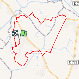
Randonnée Marche de 9,7 km à découvrir à Pays de la Loire, Loire-Atlantique, Donges. Cette randonnée est proposée par neoroll44.
Description
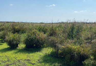
Depuis le village de Revin, près de Donges, parcourez le marais par des chemins agricoles, des petites routes et l'ancienne voie de chemin de fer.
Localisation
Pays :
France
Région :
Pays de la Loire
Département/Province :
Loire-Atlantique
Commune :
Donges
Localité :
Unknown
Départ:(Dec)
Départ:(UTM)
565692 ; 5246948 (30T) N.
Commentaires
Randonnées à proximité
![Randonnée A pied Saint-Malo-de-Guersac - Les Chaussées - Photo](https://media.geolcdn.com/t/375/260/ed9f4f37-5424-4cdf-97c9-60da3a524041.jpeg&format=jpg&maxdim=2)
![A pied A pied](https://static1.geolcdn.com/sitytour/trail-icons/100.png)
Les Chaussées
A pied
Facile
Saint-Malo-de-Guersac,
Pays de la Loire,
Loire-Atlantique,
France
![](/images/other/stat-length.png)
8,9 km | 9,3 km-effort
2h 6min
![](https://static1.geolcdn.com/siteimages/upload/files/16400158638029165_repeat_loop_refresh_sync_direction_icon.png)
Oui
![Randonnée A pied Saint-Malo-de-Guersac - Les Gagneries - Photo](https://media.geolcdn.com/t/375/260/ed9f4f37-5424-4cdf-97c9-60da3a524041.jpeg&format=jpg&maxdim=2)
![A pied A pied](https://static1.geolcdn.com/sitytour/trail-icons/100.png)
Les Gagneries
A pied
Facile
Saint-Malo-de-Guersac,
Pays de la Loire,
Loire-Atlantique,
France
![](/images/other/stat-length.png)
5,5 km | 5,7 km-effort
1h 18min
![](https://static1.geolcdn.com/siteimages/upload/files/16400158638029165_repeat_loop_refresh_sync_direction_icon.png)
Oui
![Randonnée Marche Crossac - Sur les pas de Cadou - Photo](https://media.geolcdn.com/t/375/260/31db2e32-116b-4ea2-8051-f37802eeff1d.jpeg&format=jpg&maxdim=2)
![Marche Marche](https://static1.geolcdn.com/sitytour/trail-icons/101.png)
Sur les pas de Cadou
Marche
Facile
Crossac,
Pays de la Loire,
Loire-Atlantique,
France
![](/images/other/stat-length.png)
19 km | 20 km-effort
4h 32min
![](https://static1.geolcdn.com/siteimages/upload/files/16400158638029165_repeat_loop_refresh_sync_direction_icon.png)
Oui
![Randonnée Randonnée équestre Saint-Malo-de-Guersac - TRAIL TOUR DE BRIERE - Photo](https://media.geolcdn.com/t/375/260/ext.jpg?maxdim=2&url=https%3A%2F%2Fstatic1.geolcdn.com%2Fsiteimages%2Fupload%2Ffiles%2F1524743154cheval.jpg)
![Randonnée équestre Randonnée équestre](https://static1.geolcdn.com/sitytour/trail-icons/301.png)
TRAIL TOUR DE BRIERE
Randonnée équestre
Très difficile
Saint-Malo-de-Guersac,
Pays de la Loire,
Loire-Atlantique,
France
![](/images/other/stat-length.png)
67 km | 71 km-effort
9h 16min
![](https://static1.geolcdn.com/siteimages/upload/files/16400158638029165_repeat_loop_refresh_sync_direction_icon.png)
Oui
![Randonnée Marche Montoir-de-Bretagne - Briere - Photo](https://media.geolcdn.com/t/375/260/ext.jpg?maxdim=2&url=https%3A%2F%2Fstatic1.geolcdn.com%2Fsiteimages%2Fupload%2Ffiles%2F1553511878bg_sport_marche.png)
![Marche Marche](https://static1.geolcdn.com/sitytour/trail-icons/101.png)
Briere
Marche
Montoir-de-Bretagne,
Pays de la Loire,
Loire-Atlantique,
France
![](/images/other/stat-length.png)
5,9 km | 6,2 km-effort
1h 23min
![](https://static1.geolcdn.com/siteimages/upload/files/16400158638029165_repeat_loop_refresh_sync_direction_icon.png)
Non
![Randonnée V.T.T. Crossac - Crossac 2019 - Photo](https://media.geolcdn.com/t/375/260/ext.jpg?maxdim=2&url=https%3A%2F%2Fstatic1.geolcdn.com%2Fsiteimages%2Fupload%2Ffiles%2F1524743154velo.jpg)
![V.T.T. V.T.T.](https://static1.geolcdn.com/sitytour/trail-icons/202.png)
Crossac 2019
V.T.T.
Moyen
Crossac,
Pays de la Loire,
Loire-Atlantique,
France
![](/images/other/stat-length.png)
35 km | 38 km-effort
3h 10min
![](https://static1.geolcdn.com/siteimages/upload/files/16400158638029165_repeat_loop_refresh_sync_direction_icon.png)
Non
![Randonnée Marche Saint-Malo-de-Guersac - Rando des Hérons 2019 - Photo](https://media.geolcdn.com/t/375/260/ext.jpg?maxdim=2&url=https%3A%2F%2Fstatic1.geolcdn.com%2Fsiteimages%2Fupload%2Ffiles%2F1553511878bg_sport_marche.png)
![Marche Marche](https://static1.geolcdn.com/sitytour/trail-icons/101.png)
Rando des Hérons 2019
Marche
Facile
Saint-Malo-de-Guersac,
Pays de la Loire,
Loire-Atlantique,
France
![](/images/other/stat-length.png)
15,4 km | 16,1 km-effort
3h 35min
![](https://static1.geolcdn.com/siteimages/upload/files/16400158638029165_repeat_loop_refresh_sync_direction_icon.png)
Oui
![Randonnée Marche Crossac - AUTOUR DE CROSSBAC - Photo](https://media.geolcdn.com/t/375/260/ext.jpg?maxdim=2&url=https%3A%2F%2Fstatic1.geolcdn.com%2Fsiteimages%2Fupload%2Ffiles%2F1553511878bg_sport_marche.png)
![Marche Marche](https://static1.geolcdn.com/sitytour/trail-icons/101.png)
AUTOUR DE CROSSBAC
Marche
Très facile
Crossac,
Pays de la Loire,
Loire-Atlantique,
France
![](/images/other/stat-length.png)
16,4 km | 17,7 km-effort
3h 18min
![](https://static1.geolcdn.com/siteimages/upload/files/16400158638029165_repeat_loop_refresh_sync_direction_icon.png)
Oui