![](/images/other/stat-length.png)
![Randonnée Marche Mont Lozère et Goulet - Sources du Tarn - Photo](https://media.geolcdn.com/t/1900/400/ext.pjpeg?maxdim=2&url=https%3A%2F%2Fstatic1.geolcdn.com%2Fsiteimages%2Fupload%2Ffiles%2F1553511878bg_sport_marche.png)
Sources du Tarn
sphinkie
Utilisateur
![Longueur](/images/other/stat-length.png)
Longueur
18,2 km
![Altitude max](https://static1.geolcdn.com/siteimages/upload/files/1508320355ic_sort_altitude_max_24dp.png)
Altitude max
1577 m
![Dénivelé positif](https://static1.geolcdn.com/siteimages/upload/files/1508320355ic_sort_den_pos_24dp.png)
Dénivelé positif
371 m
![Km-Effort](/images/other/stat-length.png)
Km-Effort
23 km
![Altitude min](https://static1.geolcdn.com/siteimages/upload/files/1508320355ic_sort_altitude_min_24dp.png)
Altitude min
1348 m
![Dénivelé négatif](https://static1.geolcdn.com/siteimages/upload/files/1508320355ic_sort_den_neg_24dp.png)
Dénivelé négatif
369 m
![Boucle](https://static1.geolcdn.com/siteimages/upload/files/16400158638029165_repeat_loop_refresh_sync_direction_icon.png)
Boucle
Oui
Date de création :
2014-12-10 00:00:00.0
Dernière modification :
2014-12-10 00:00:00.0
![Marche](https://static1.geolcdn.com/sitytour/trail-icons/101.png)
4h57
Difficulté : Facile
![Scannez ce code QR pour ouvrir la randonnée dans l'application SityTrail](https://capi.geolives.com/qq0zvz2zws4bq2lad0pu/sitytour/trails/165933/qr.png?size=200)
Application GPS de randonnée GRATUITE
À propos
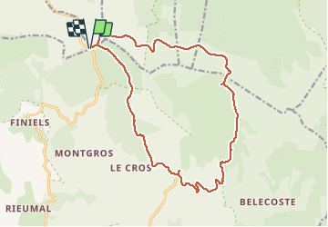
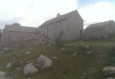
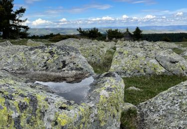
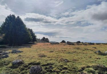
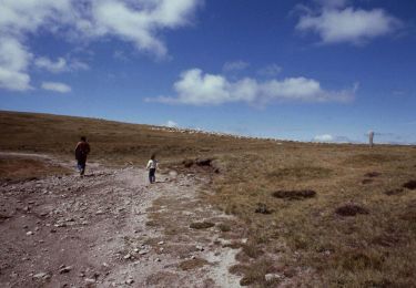
Randonnée Marche de 18,2 km à découvrir à Occitanie, Lozère, Mont Lozère et Goulet. Cette randonnée est proposée par sphinkie.
Description
6h:30 | 18.1km A/R
6h:30 | 18.1km A/R
Longueur - 18.1km
Points - 715
Créé - 2012-08-03 09:30:37
Vitesse Max - 127km/h
Altitude Min - 1404m
Altitude Max - 1628m
Localisation
Pays :
France
Région :
Occitanie
Département/Province :
Lozère
Commune :
Mont Lozère et Goulet
Localité :
Mas-d'Orcières
Départ:(Dec)
Départ:(UTM)
561236 ; 4919242 (31T) N.
Commentaires
Randonnées à proximité
![Randonnée V.T.T. Cubières - TOUR MONT LOZERE - Photo](https://media.geolcdn.com/t/375/260/a1bfdb58-8337-4d84-b53e-6cb2f940b716.jpeg&format=jpg&maxdim=2)
![V.T.T. V.T.T.](https://static1.geolcdn.com/sitytour/trail-icons/202.png)
TOUR MONT LOZERE
V.T.T.
Très difficile
(1)
Cubières,
Occitanie,
Lozère,
France
![](/images/other/stat-length.png)
38 km | 47 km-effort
3h 14min
![](https://static1.geolcdn.com/siteimages/upload/files/16400158638029165_repeat_loop_refresh_sync_direction_icon.png)
Oui
![Marche Marche](https://static1.geolcdn.com/sitytour/trail-icons/101.png)
Les prairies du col de Finiels et des monts Lozere
Marche
Moyen
(1)
Mont Lozère et Goulet,
Occitanie,
Lozère,
France
![](/images/other/stat-length.png)
7,2 km | 9,5 km-effort
2h 59min
![](https://static1.geolcdn.com/siteimages/upload/files/16400158638029165_repeat_loop_refresh_sync_direction_icon.png)
Oui
![Randonnée Marche Pont de Montvert - Sud Mont Lozère - Finiels/ sommet / station du Bleymard en boucle - Photo](https://media.geolcdn.com/t/375/260/f8048304-3a05-4fd0-a0e7-03457722fcee.jpg&format=jpg&maxdim=2)
![Marche Marche](https://static1.geolcdn.com/sitytour/trail-icons/101.png)
Finiels/ sommet / station du Bleymard en boucle
Marche
Difficile
Pont de Montvert - Sud Mont Lozère,
Occitanie,
Lozère,
France
![](/images/other/stat-length.png)
20 km | 30 km-effort
5h 38min
![](https://static1.geolcdn.com/siteimages/upload/files/16400158638029165_repeat_loop_refresh_sync_direction_icon.png)
Oui
![Randonnée Marche Pont de Montvert - Sud Mont Lozère - Cévennes Mas Camargues Pont du Tarn - Photo](https://media.geolcdn.com/t/375/260/ext.jpg?maxdim=2&url=https%3A%2F%2Fservices.sitytrail.com%2FGeolivesWS%2FDownloadMedia.ashx%3FTrailID%3D345700%26Media%3Dfix__20140916143911.jpg)
![Marche Marche](https://static1.geolcdn.com/sitytour/trail-icons/101.png)
Cévennes Mas Camargues Pont du Tarn
Marche
Facile
(1)
Pont de Montvert - Sud Mont Lozère,
Occitanie,
Lozère,
France
![](/images/other/stat-length.png)
7,4 km | 8,6 km-effort
2h 7min
![](https://static1.geolcdn.com/siteimages/upload/files/16400158638029165_repeat_loop_refresh_sync_direction_icon.png)
Oui
![Randonnée Marche Mont Lozère et Goulet - sources du tarn - Photo](https://media.geolcdn.com/t/375/260/ext.jpg?maxdim=2&url=https%3A%2F%2Fstatic1.geolcdn.com%2Fsiteimages%2Fupload%2Ffiles%2F1553511878bg_sport_marche.png)
![Marche Marche](https://static1.geolcdn.com/sitytour/trail-icons/101.png)
sources du tarn
Marche
Moyen
(1)
Mont Lozère et Goulet,
Occitanie,
Lozère,
France
![](/images/other/stat-length.png)
13,3 km | 17,3 km-effort
3h 50min
![](https://static1.geolcdn.com/siteimages/upload/files/16400158638029165_repeat_loop_refresh_sync_direction_icon.png)
Non
![A pied A pied](https://static1.geolcdn.com/sitytour/trail-icons/100.png)
L'Hopital - Croix de Berthel
A pied
Facile
Pont de Montvert - Sud Mont Lozère,
Occitanie,
Lozère,
France
![](/images/other/stat-length.png)
9,6 km | 11,8 km-effort
2h 41min
![](https://static1.geolcdn.com/siteimages/upload/files/16400158638029165_repeat_loop_refresh_sync_direction_icon.png)
Non
![Randonnée Vélo électrique Cubières - ETANG DE BARANDON PAR LA STATION DE SKI - Photo](https://media.geolcdn.com/t/375/260/02cfb49c-be69-4aa6-8d1f-cab2e83a60e7.jpeg&format=jpg&maxdim=2)
![Vélo électrique Vélo électrique](https://static1.geolcdn.com/sitytour/trail-icons/205.png)
ETANG DE BARANDON PAR LA STATION DE SKI
Vélo électrique
Moyen
Cubières,
Occitanie,
Lozère,
France
![](/images/other/stat-length.png)
31 km | 36 km-effort
2h 11min
![](https://static1.geolcdn.com/siteimages/upload/files/16400158638029165_repeat_loop_refresh_sync_direction_icon.png)
Oui
![Randonnée A pied Pont de Montvert - Sud Mont Lozère - Sentier de Mas Camargues - Photo](https://media.geolcdn.com/t/375/260/666f6cbe-ccb7-4fdf-9e76-666a378e8f76.jpeg&format=jpg&maxdim=2)
![A pied A pied](https://static1.geolcdn.com/sitytour/trail-icons/100.png)
Sentier de Mas Camargues
A pied
Facile
Pont de Montvert - Sud Mont Lozère,
Occitanie,
Lozère,
France
![](/images/other/stat-length.png)
3,1 km | 3,9 km-effort
52min
![](https://static1.geolcdn.com/siteimages/upload/files/16400158638029165_repeat_loop_refresh_sync_direction_icon.png)
Oui
![Randonnée A pied Pont de Montvert - Sud Mont Lozère - chemin de Malevrère - Photo](https://media.geolcdn.com/t/375/260/16465856-fafb-4a01-b9f2-86d3a81ef11b.jpeg&format=jpg&maxdim=2)
![A pied A pied](https://static1.geolcdn.com/sitytour/trail-icons/100.png)
chemin de Malevrère
A pied
Facile
Pont de Montvert - Sud Mont Lozère,
Occitanie,
Lozère,
France
![](/images/other/stat-length.png)
3,1 km | 4,4 km-effort
1h 0min
![](https://static1.geolcdn.com/siteimages/upload/files/16400158638029165_repeat_loop_refresh_sync_direction_icon.png)
Non